The biggest potential with this round of storms will be for very strong straight-line winds and an isolated tornado or two. Hail is also expected to accompany some of these storms, which will also help the storms reach severe criteria.
A WPSD Local 6 Weather Authority Alert is in effect Wednesday for the potential of severe thunderstorms moving through the television station’s viewing area.
A storm system will move into the region and help add lift to the atmosphere and a lot of energy to the thunderstorms that develop. A lot of Gulf moisture has moved into the area over the past couple of days, which is what is needed to add energy and water to the air to fuel thunderstorms. Dewpoints in the lower 70s mean that the atmosphere is saturated with water at the surface.
The biggest potential with this round of storms will be for very strong straight-line winds and an isolated tornado or two. Hail is also expected to accompany some of these storms, which will also help the storms reach severe criteria.
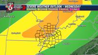
There is already an enhanced risk of severe weather for the northern half of WPSD’s viewing area, including southern Illinois and southeastern Missouri, down to the Ohio River, while the rest of the area will be under a slight risk.
The best potential for storms will arrive in a couple of waves, but the most likely squall line will pass through the area into Wednesday night and early Thursday morning. While this is a fluid forecast regarding the timing of the storms, everyone is advised to make sure they have a way to receive any alerts about watches or warnings as they are issued throughout our area during the day and into the evening.
Traditionally, in the month of June, we do not deal with much in the way of severe weather; that’s reserved for a higher latitude portion of the country. But, this wave will pass through quickly, and it will likely be the last of our severe threats for the coming months.
Following the storms, a blast of hot air is forecast for the area. By Friday and into the weekend, expect temperatures to reach the middle 90s with a lot of moisture to make it very muggy. That will help push up the heat index/feels like temperature, topping out in the low 100s. This is the first hot weather for 2025, so be sure to cool off often when outside for any extended period of time, especially during strenuous activities, and drink water the night before.
To stay informed on the latest weather conditions, download the WPSD Local 6 weather app. To find the app, search “WPSD Radar” in the Apple App Store or Google Play. To learn more about the app, visit wpsdlocal6.com/apps. Amid Wednesday’s severe weather threat, the television station will also provide updates on air, online at wpsdlocal6.com and via its Facebook page.
Meteorologist Mark Daniels is a member of WPSD Local 6’s Weather Authority team.