
I’ve spent countless weekends roaming northern New Hampshire with a camera in one hand and a trail map in the other, and I never tire of the way the mountains roll into riverside villages and tiny main streets.
From hushed Great North Woods ponds to bustling ski-town sidewalks, the region strings together a surprising variety of scenery within just a few winding drives.
The 15 towns below are the ones I keep recommending to friends who ask where they can mix postcard views with easy access to trails, waterfalls, and winding backroads. Each has its own flavor—some artsy, some rustic, some polished by tourism—but all feel rooted in the North Country’s granite landscape.
If you’re plotting a foliage loop, a powder-day basecamp, or a summer paddling escape, start your short list here. I’ve counted them down so the suspense builds to my favorite.
15. Errol – A Quiet Escape on the Edge of the Wilderness
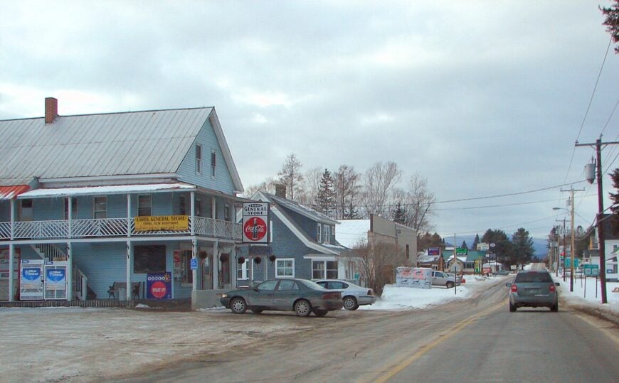
Errol sits at the northern tip of New Hampshire, where the Androscoggin River winds through dense forests and rolling hills. I like it for its solitude—there’s a peacefulness here that’s hard to find elsewhere.
The town is a gateway to Umbagog Lake, a sprawling body of water perfect for kayaking and spotting bald eagles. I always make time for a slow paddle along the shoreline, where moose sometimes wade in the shallows.
Errol’s general store is a must-stop for supplies before heading deeper into the wilderness, and the nearby trails offer miles of hiking and snowmobiling. Errol offers 2-4 bedroom homes priced between $319,000 and $625,000, making it a great option for those looking for a secluded getaway.
Where is Errol?
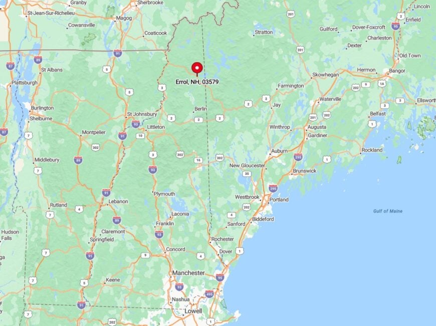
Errol lies in Coös County, at the junction of Routes 16 and 26, just south of the Maine border. The town is surrounded by vast stretches of protected land, giving it an untouched feel.
You can reach Errol by following NH-16 north from Berlin or NH-26 east from Colebrook. Either route delivers winding roads, scenic overlooks, and a sense of leaving the modern world behind.
14. Milan – A Hidden Gem Along the Androscoggin
Milan is one of those places that doesn’t try too hard—it just exists in its quiet, understated way. I like it for its simplicity, where the Androscoggin River carves through the landscape, offering some of the best fishing and paddling in the region.
The town is home to Milan Hill State Park, where a fire tower climb rewards you with panoramic views stretching into Maine. I always take a moment at the top to soak in the endless ridgelines.
Milan’s backroads are perfect for a slow drive, passing old farmsteads and fields that glow golden in the late afternoon light. It’s a place where life moves at a different pace, and that’s exactly why I keep coming back.
Milan offers 3-5 bedroom homes priced between $295,000 and $525,000, making it an affordable yet scenic option for those that are looking to settle in the North Country.
Where is Milan?
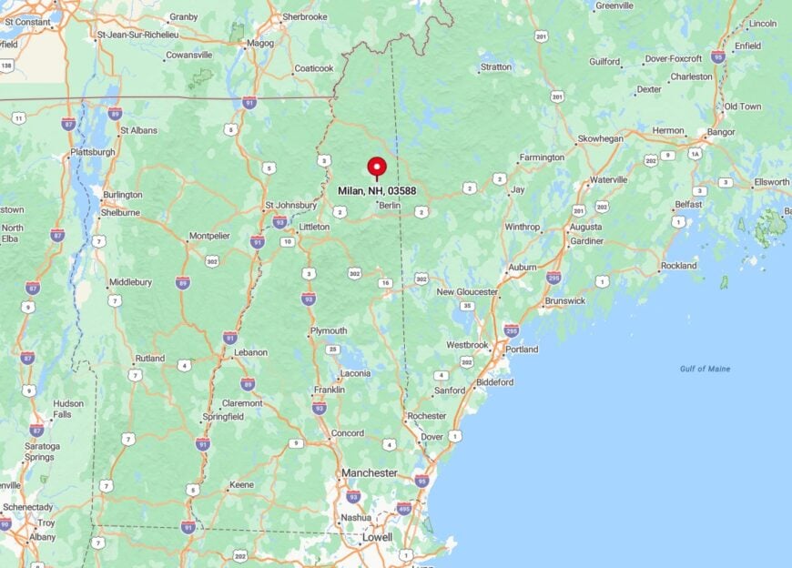
Milan sits in Coös County, just north of Berlin along NH-110A. The town is tucked between the Androscoggin River and the rolling foothills of the White Mountains in New Hampshire.
You can reach Milan by following NH-16 north from Gorham or NH-110 west from Berlin. The drive is peaceful and quiet, with glimpses of the river and occasional wildlife crossings.
13. Bretton Woods – Majestic Views Near Mount Washington
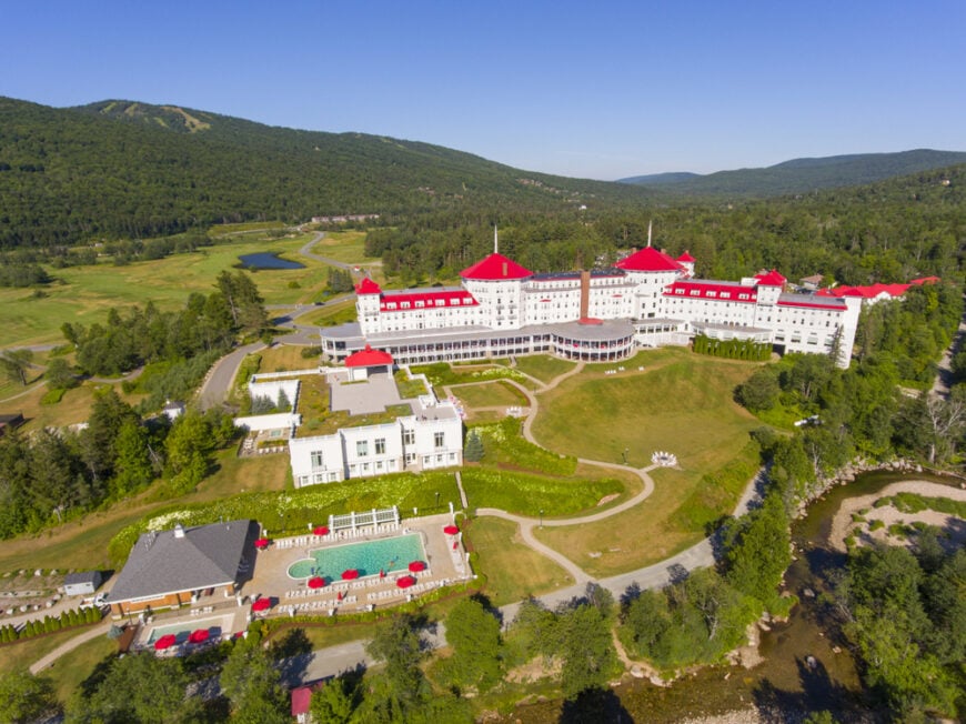
Whenever I crave grand alpine scenery without a demanding approach hike, I book a night—or at least a sunset drink—at the Omni Mount Washington Resort in Bretton Woods.
The hotel’s sweeping veranda frames the Presidential Range so perfectly it feels like an IMAX screen, and I’ve lost track of the hours spent watching clouds skid across Mount Washington’s summit.
In winter, Bretton Woods Ski Area offers the most extensive skiable acreage in the state, with gentle glades that make even novice friends grin ear to ear.
Summer swaps skis for gondola rides, zip-line tours, and mountain-top disc golf, though I usually sneak off to the less-known Fabyan Falls Trail for a secluded picnic beside cascades.
Nordic skiers and fat-bikers can roam a 100-kilometer trail network that winds past beaver ponds and birch stands. If the weather sours, I duck into The Cave—a Prohibition-era speakeasy in the hotel basement—where the stone walls practically drip with history.
Bretton Woods presents 3-4 bedroom homes ranging from $570,000 to $670,000, offering luxury living surrounded by some of the most breathtaking outdoor landscapes in the area.
Where is Bretton Woods?

Bretton Woods occupies a high plateau along U.S. Route 302, about nine miles west of the top of Crawford Notch and 15 miles east of Littleton. The Ammonoosuc River threads through the valley, and the Presidential Range rises immediately to the south, giving the area its iconic skyline.
Most travelers reach Bretton Woods by following Route 302 from either direction, a drive famous for pull-offs that reveal waterfalls and boulder-lined river bends. Because there’s no actual “downtown,” the resort complex and ski base area effectively form the town center, with trailheads fanning out in every direction.
12. Lancaster – Historic Sites Amidst Mountain Backdrops
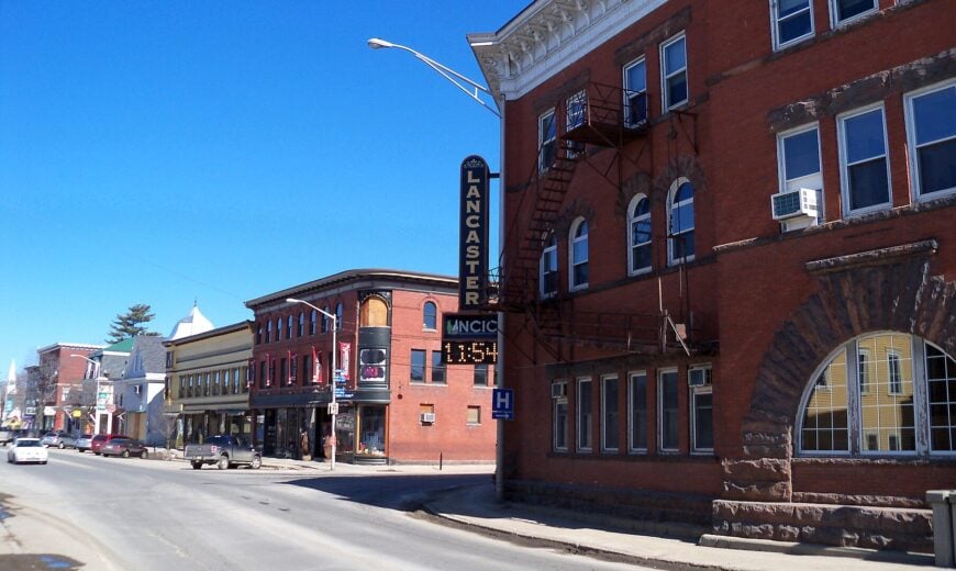
Set against the distant silhouettes of the Presidential Range, Lancaster’s brick storefronts and painted Victorians make me feel like I’ve stepped into a sepia photograph. However, the town’s vibe is anything but dated.
Main Street hosts the annual Lancaster Fair, the state’s oldest, where I’ve devoured more maple cotton candy than I care to admit. For a quick dose of nature, I head up Weeks State Park; the stone fire tower at the summit grants 360-degree views that include Quebec on a clear day.
Cyclists appreciate the relatively flat Presidential Rail Trail that shoots east toward Gorham, offering moose-spotting chances at dawn. Hidden gem alert: “Pollyanna Gateway,” a bronze statue honoring local author Eleanor H. Porter, sits nearby Littleton, but many fans don’t realize Lancaster claims Porter’s birthplace.
After sunset, Lancaster’s minimal light pollution turns the ballfields behind the high school into my impromptu stargazing spot. Lancaster offers 3-4 bedroom homes priced between $340,000 and $440,000, a charming base for those who want to explore the town’s scenic beauty and outdoor recreation.
Where is Lancaster?

Lancaster anchors northern Coös County at the junction of U.S. Routes 2 and 3, making it a strategic stop for anyone looping the Great North Woods. The town spans both sides of the Connecticut River, creating bucolic farmland vistas framed by snow-capped peaks in winter.
From I-93, most visitors exit at Littleton and follow Route 135 north along the river for a scenic forty-minute drive. Because Amtrak and intercity buses bypass this stretch, arriving by car remains the simplest way to tap into Lancaster’s historic charm and trail access.
11. Colebrook – Northern Charm and Access to Trails
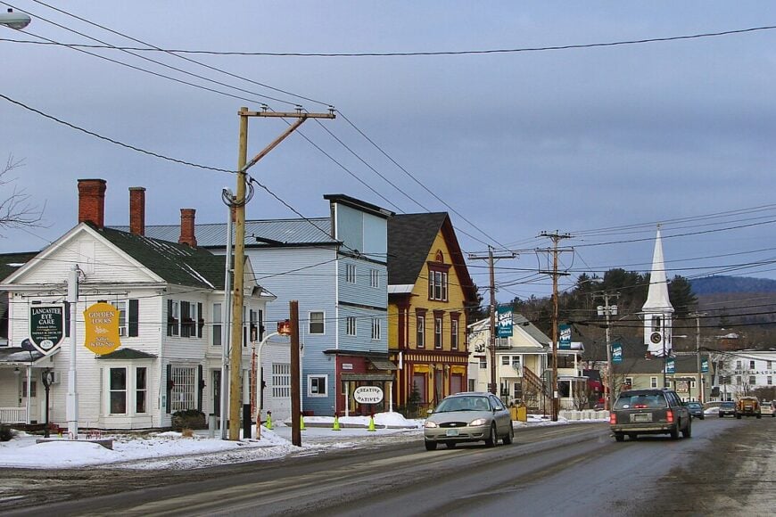
Colebrook is where I head when I want to feel genuinely remote without sacrificing a good cup of coffee—the impossibly friendly Aries Bakery & Café handles that requirement nicely. The town’s location along the Connecticut River means dawn often breaks with low fog curling over the water, a photographer’s dream.
Not far away, the Cohos Trail crosses Route 3, providing a gateway to 170 miles of little-traveled paths through forests where spruce grouse outnumber hikers.
ATV riders flock here in summer for Ride the Wilds, New England’s largest interconnected trail network, yet I prefer walking the River Walk that loops behind downtown and past the historic covered bridge.
Winter brings snowmobile traffic buzzing into town, but you can still steal quiet moments snowshoeing around Beaver Brook Falls, a 110-foot cascade that often ices into surreal shapes.
Colebrook may be small, but its proximity to Canada and the wild Dixville Notch region makes it feel like the North Country’s final frontier. Colebrook has 3-4 bedroom homes priced from $110,000 to $210,000, a more affordable option for outdoor enthusiasts looking to immerse themselves in nature.
Where is Colebrook?
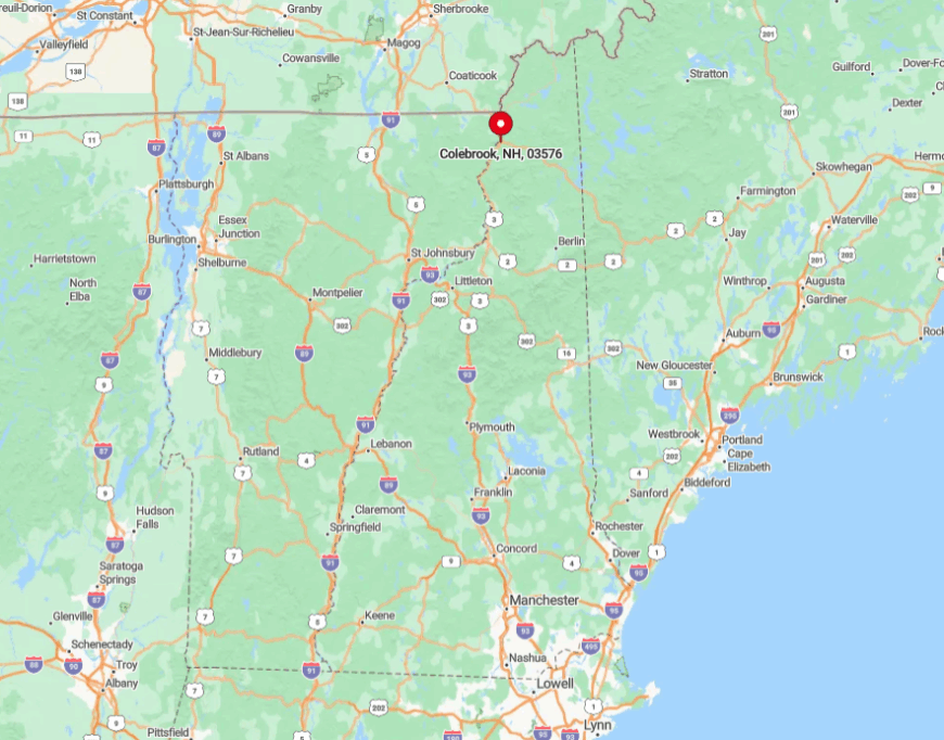
Colebrook sits on U.S. Route 3, twenty miles south of the Canadian border and roughly the same distance north of Pittsburgh. The town hugs a bend in the Connecticut River, while the rugged Mahoosuc Range rises to the east, giving travelers a sense of being funneled into true wilderness.
Reaching Colebrook involves a scenic two-hour drive north from Franconia Notch via Route 3, or you can approach from Vermont across the Columbia Bridge. Its far-flung location discourages day-trippers, rewarding those who commit to the journey with wide-open skies, light traffic, and trails that start practically at the town line.
10. Bartlett – Scenic Beauty Along the Saco River
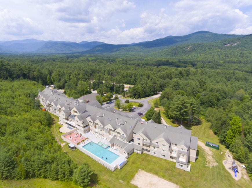
Every time I crest the hill just before Bartlett village, the view of Attitash Mountain’s ski slopes plunging toward the Saco River reminds me why this stretch of Route 302 is a favorite. In warmer months, the river becomes a playground for tubing and fishing, with quiet gravel pull-offs that locals guard like secret recipes.
I’m fond of hiking to Diana’s Baths via a little-known backdoor trail from West Side Road, avoiding the crowded main lot. Mountain bikers will appreciate the Castle in the Clouds-style singletrack at Bear Notch, though my indulgence is a post-ride maple creamer at The Bartlett Village Store.
When winter returns, Attitash’s alpine slides morph into powdery glades, and the nearby Bear Notch Ski Touring Center opens 65 kilometers of groomed Nordic track that rarely feels busy.
Bartlett might appear as a blip on the map. Still, its riverbank setting offers a constant soundtrack of rushing water that underscores every adventure. Bartlett presents 3-4 bedroom homes priced between $120,000 and $220,000, an excellent option for those seeking affordable living with easy access to local hiking trails.
Where is Bartlett?
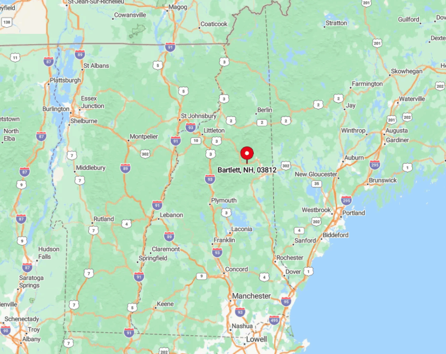
Bartlett straddles U.S. Route 302 roughly halfway between North Conway and Bretton Woods, making it a natural mid-valley base. The village clusters against the Saco River while forested ridges rise steeply on both sides, creating a snug corridor that glows gold during foliage season.
Drivers from the south often take NH-16 to North Conway and hook left onto Route 302, whereas travelers from Vermont cruise over Crawford Notch for a dramatic entrance. A small railroad depot marks the heart of town, and limited public transit means you’ll want your wheels to reach the trailheads sprinkled along the valley.
9. Pittsburg – Remote Wilderness and Lake Adventures
Pittsburg feels like the edge of civilization, where moose outnumber people and the night sky ditches street-light haze for Milky Way glory. The chain of four Connecticut Lakes steps north toward Canada, each offering progressively quieter coves where I’ve spotted loons, eagles, and once, a curious river otter.
Anglers pursue trophy-size landlocked salmon at First Connecticut Lake, while paddlers favor the glassy waters of Back Lake at dawn for the morning mist and chorus of white-throated sparrows. I’m partial to hiking the Falls in the River Trail, a gentle path that rewards with cascades hidden just feet from the Quebec border.
Snowmobiling dominates winter, yet the summer solitude—especially on mid-week mornings—is what makes Pittsburg feel like my personal state-size park. Don’t skip Young’s Store for a breakfast sandwich; it doubles as the unofficial visitors center where locals happily mark moose hotspots on your map.
Pittsburg offers 3-4 bedroom homes in the $290,000 to $390,000 range, making it an ideal location for those wanting to explore the wilderness and enjoy year-round outdoor activities.
Where is Pittsburg?

The town occupies New Hampshire’s northernmost tip, stretching along U.S. Route 3 for nearly thirty miles to the Canadian customs station at Chartierville, Quebec. Its geography is remarkable: Pittsburg’s boundaries encompass 291 square miles, larger than many New England counties, but with fewer than a thousand residents.
Most visitors drive two hours north of Franconia Notch via Route 3, a journey that transitions from ski-town bustle to deep-forest quiet. Because commercial flights and trains are absent, your car—or snowmobile in winter—remains the ticket into this remote playground.
8. Sugar Hill – Fields of Lupines and Panoramic Vistas
Come early June, Sugar Hill explodes with purple, pink, and white lupines that ripple like a floral ocean below the peaks of the Franconia Range—an event I never skip, even if it means setting a 4 a.m. alarm.
The rest of the year, the little town offers sweeping meadow overlooks where the sunset bathes Mount Lafayette in honey tones, best viewed from Sunset Hill Road.
I always stop at Polly’s Pancake Parlor for buckwheat-blueberry cakes drenched in locally tapped syrup, then walk it off on the short but viewpoint-rich Coffin Pond Trail. Photographers gravitate to the rustic St. Matthew’s Chapel framed by birch trees; its simple lines echo the town’s uncluttered charm.
For a lesser-known outing, the Bronson Hill out-and-back leads to an abandoned farmstead with stone walls and an unbroken vista of the Kinsmans. Sugar Hill is tiny, but its elevated perch provides some of the most expansive panoramas in the Whites, proving you don’t need a summit to feel on top of the world.
Sugar Hill features 3-4 bedroom homes priced between $780,000 and $880,000, providing an upscale base for those looking to enjoy luxurious living amid scenic mountain views.
Where is Sugar Hill?
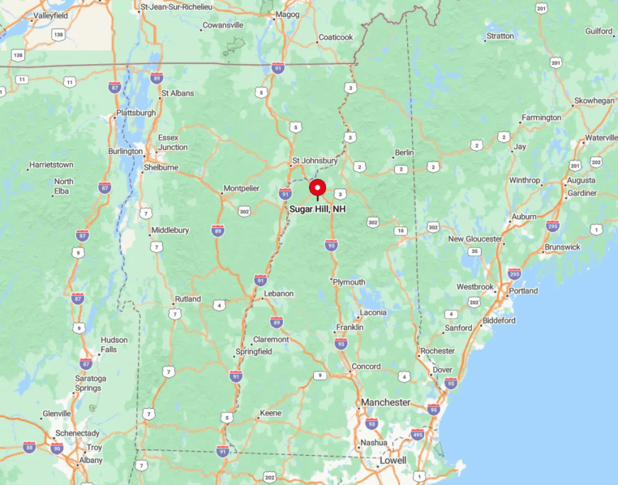
Sugar Hill rests on a high plateau just west of Franconia, accessed via NH-117 off I-93’s Exit 38. Because the village sits 1,500 feet above sea level, every road into town feels like a gentle climb through maple stands that blaze red each October.
The nearest interstate exit is only ten minutes away, yet the final miles along Lupine Road feel blissfully rural, with no gas stations or chain stores to break the spell. Winter travelers should note that the hilltop location can collect more snow than the valley, so carry adequate tires to enjoy those frosty vistas safely.
7. Bethlehem – Artsy Town Surrounded by Natural Beauty
Bethlehem punches well above its weight in creative energy, thanks to a cluster of galleries, the vintage Colonial Theatre, and rotating outdoor sculpture exhibits that decorate Main Street each summer.
When I need a mid-ride caffeine fix, I lean my bike outside Rek’-lis Brewing and savor a Hazy IPA while perusing local photography hung on the walls. Scenic drivers can loop along Trudeau Road for a shady cruise that delivers patio-worthy mountain views without leaving pavement.
Hikers frequent the Mount Agassiz Trail for a quick after-work ascent that rewards with a surprisingly sweeping vista of the Presidential Range.
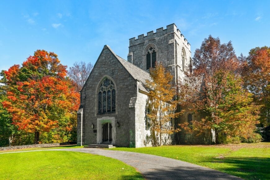
My insider tip: search out the 100-year-old Bethlehem Hebrew Congregation synagogue; its stained-glass windows glow like jewels at sunset and serve as a testament to the town’s storied past as a summer resort for city dwellers.
Between art walks and ridge walks, Bethlehem offers the perfect blend of culture and countryside. Bethlehem offers 3-4 bedroom homes priced between $290,000 and $390,000, an ideal town for those seeking to explore the outdoors while enjoying charming small-town vibes.
Where is Bethlehem?
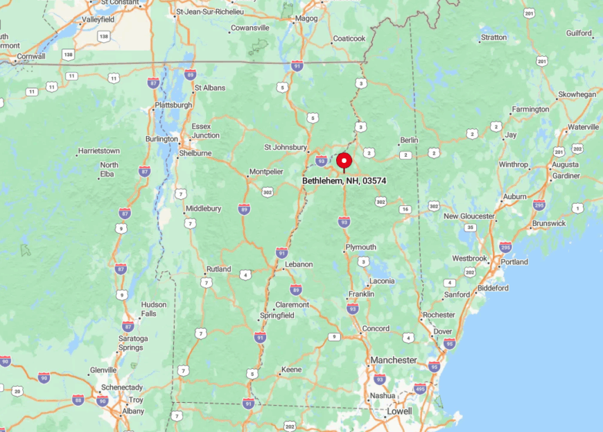
The village lies directly on U.S. Route 302 and parallel to I-93’s northern stretch, roughly five miles east of Littleton. Perched at 1,500 feet, Bethlehem enjoys cooler summer temperatures and crisp mountain air—part of why 19th-century vacationers dubbed it the “Star of the White Mountains.”
Drivers can exit I-93 at either Exit 37 or 40 and follow signs into town in under ten minutes. Its strategic location places Franconia Notch, Crawford Notch, and the Ammonoosuc River all within a short drive, making Bethlehem a natural home base for varied day trips.
6. Gorham – Scenic Trails and Wildlife in the Great North Woods

When I crave steep elevation gains, I head for Gorham, where Mount Madison and Mount Washington trailheads rise practically from the town limits. The Androscoggin River slices through the center, turning pinkish-gold at dusk and drawing anglers eager to nab landlocked salmon.
Moose sightings are almost ho-hum here; I’ve spotted three while cycling the flat Presidential Rail Trail toward Randolph in a single evening. In summer, the 4th of July festivities culminate in fireworks mirrored on the river—small-town Americana at its finest.
Winter brings cross-country skiers to Moose Brook State Park, whose impeccably groomed loops wind through spruce groves. After any outing, I refuel at Mountain Fire Pizza, where local climbers swap beta for the challenging “Pinnacle Buttress” routes over slices of wood-fired pie.
Gorham provides 3-4 bedroom homes priced between $160,000 and $260,000, offering an affordable entry point for outdoor enthusiasts who want easy access to hiking and skiing.
Where is Gorham?
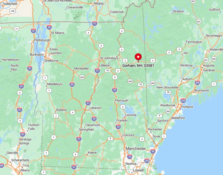
Gorham occupies the eastern gateway to the White Mountains along U.S. Route 2, about eight miles east of Pinkham Notch. The town sits in a valley carved by the Androscoggin, with the Carter-Moriah Range hemming it to the south and the crescent of the Kilkenny Range to the north.
Most visitors arrive via Route 16 from North Conway or Route 2 from Vermont, both drives showcasing waterfall pull-offs and sweeping ridge lines. Since no interstate reaches this corner, Gorham retains a pleasantly remote feel while offering all the essentials for backcountry excursions.
5. Randolph – A Mountain Haven in the Presidential Range
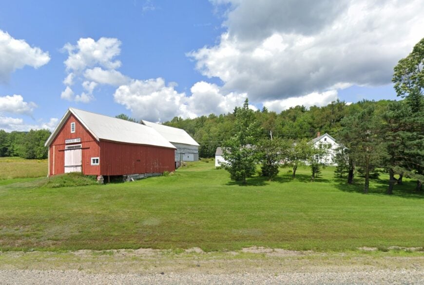
Randolph is the kind of place where the mountains feel close enough to touch. I like it for its proximity to the Presidential Range, where some of the best hiking trails in New Hampshire begin.
The town is home to the Randolph Mountain Club, which maintains a network of trails leading to stunning viewpoints. I always make time for a hike up Lowe’s Path, where the views of Mount Adams never disappoint.
Randolph’s small community is tight-knit, with a deep appreciation for the outdoors. It’s the kind of place where people swap trail stories, and where the wilderness is just a step away. Randolph offers 3-5 bedroom homes priced between $799,000 and $1,359,000, making it a prime location for those seeking a mountain retreat.
Where is Randolph?
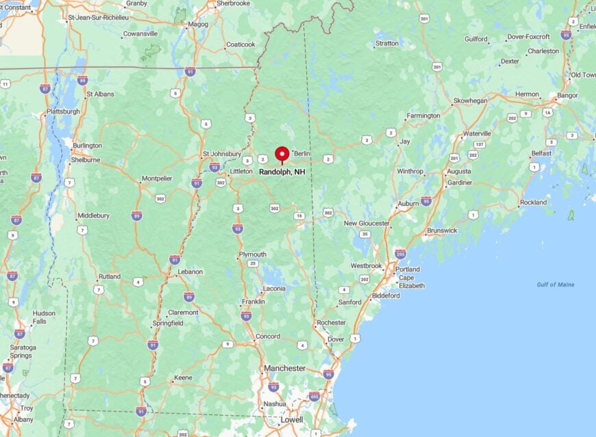
Randolph lies in Coös County, along US Route 2, nestled between Gorham and Jefferson. The town is surrounded by the White Mountain National Forest, giving it a secluded yet accessible feel.
You can reach Randolph by following US-2 west from Gorham or east from Lancaster. The drive is lined with towering peaks, making it one of the most scenic routes in the state.
4. Franconia – Gateway to Franconia Notch State Park
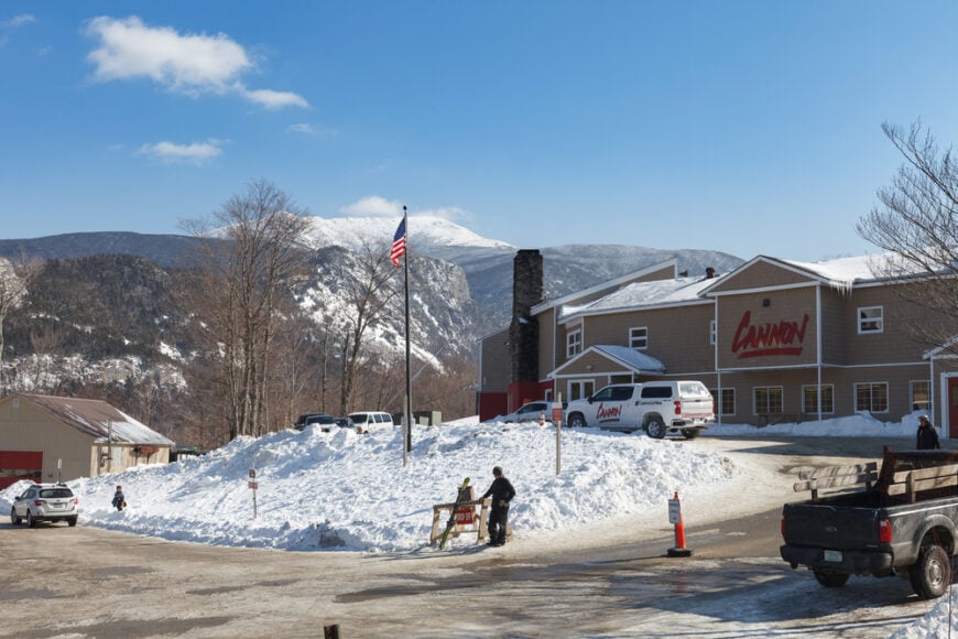
Franconia might look sleepy from the highway, but it’s the launchpad for classic hikes like Mount Lafayette and Cannon Mountain, which rank in my top five for summit views. The Flume Gorge’s wooden boardwalks threading between sheer granite walls prove that geology lectures can be thrilling.
I often start my day at Iron Furnace Brewing, where the taproom sits inside an old barn overlooking the Gale River, then head out to bike the paved Franconia Notch Recreation Path that skirts Echo Lake.
Winter lures me back for Cannon’s famous tramway rides, whisking skiers to the summit in under ten minutes—a merciful shortcut on frigid mornings. If crowds aren’t your thing, the lesser-known Artist’s Bluff trail rewards with a postcard-worthy perch above the lake in just 30 minutes.
Franconia’s setting, sandwiched right between cliff walls and river valleys, practically guarantees a view from any bar stool or porch swing. Franconia features 3-4 bedroom homes priced between $520,000 and $620,000, a great spot for those seeking to explore the White Mountains while enjoying a peaceful retreat.
Where is Franconia?
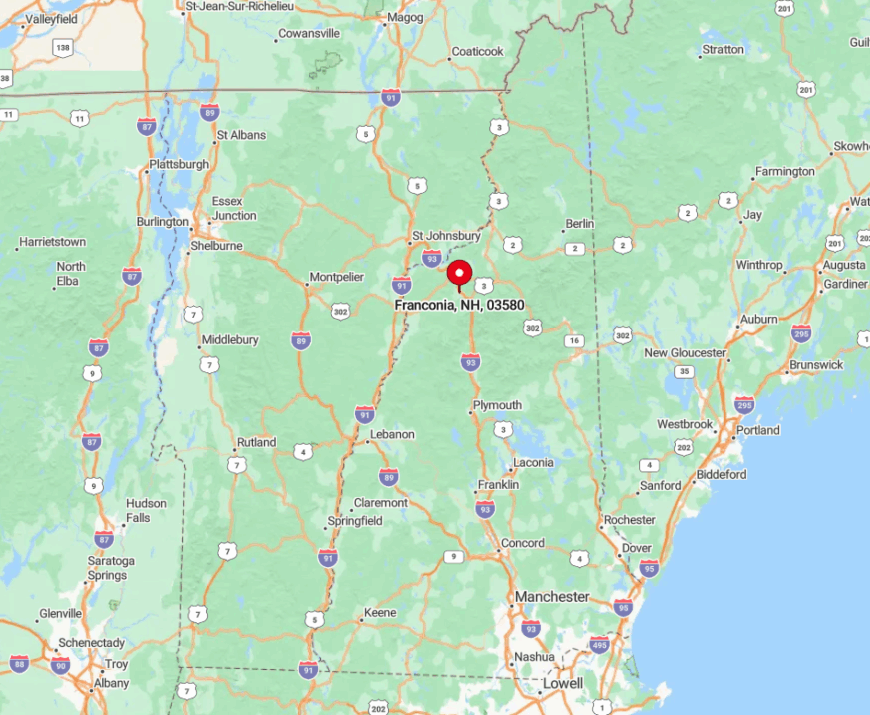
The village sits north of Franconia Notch on NH-Route 116, two miles west of I-93’s Exit 38. It occupies a broad river valley beneath Mount Lafayette’s towering profile, offering quick access to both notch attractions and back-road serenity.
Arrive via I-93 for the fastest route, or loop in from Sugar Hill on Route 117 for a quieter, more scenic approach. With the White Mountain National Forest enveloping three sides, trailheads begin mere minutes from the town’s single traffic light.
3. Littleton – Historic Main Street with Mountain Views
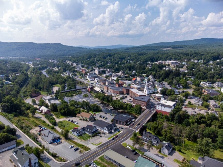
Littleton merges small-town nostalgia with youthful energy, and every time I cross the covered wooden footbridge spanning the Ammonoosuc River, I catch myself grinning like a tourist even after dozens of visits.
Main Street’s brick façades house indie gems like Chutters—the world-record holder for the longest candy counter—and the Schilling Beer Co. taproom inside a restored grist mill where river views rival the Belgian-style ales.
Outdoor enthusiasts will find bike rentals and shuttle services that unlock the nearby Parker Mountain trails, but I often steal a peaceful hour walking the River District Art Walk, dotted with murals and sculptures.
Just upstream, Moore Dam Reservoir offers SUP sessions framed by long, low ridgelines, while evenings invite a sunset stroll up to Kilburn Crags for a quick, crowd-free overlook of the entire valley.
The town’s mantra, “Be glad,” emblazoned on a historic sign downtown, pretty much sums up how I feel every time I visit. Littleton offers 3-4 bedroom homes priced between $390,000 and $490,000, providing a perfect combination of scenic surroundings and outdoor activities for nature lovers.
Where is Littleton?
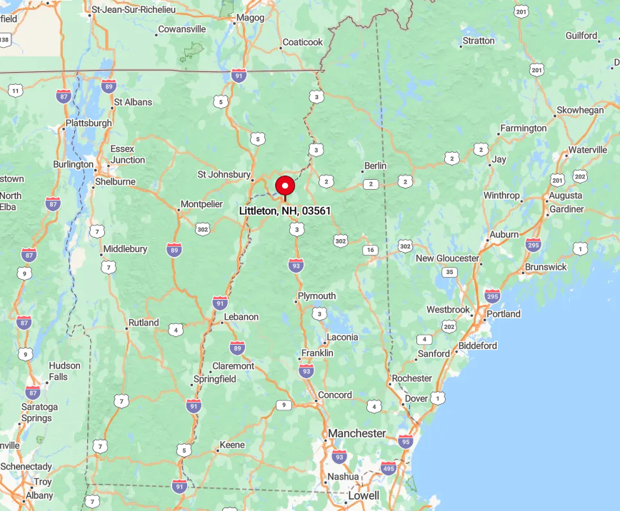
Littleton perches on I-93 at Exit 41, making it one of the easiest North Country towns to reach from southern New England. The Ammonoosuc River slices downtown, with the Green and Dalton Mountains framing the horizon to the north and east.
Drivers arriving via Route 302 cross a metal truss bridge that visually signals the shift from forest to vibrant small city. Public transit options remain limited, so I recommend a car to fully explore the radius of mountains, lakes, and backroads surrounding this lively hub.
2. Jackson – Quaint Covered Bridges and Waterfalls Galore
Jackson feels like a storybook village, from the Honeymoon Covered Bridge draped in white lights at Christmas to the cascade-filled Ellis River that hums alongside many footpaths.
I never skip Jackson Falls, where flat granite slabs create natural picnic tables and the water is shallow enough for kids—or in my case, grown-ups acting like kids—to wade.
Winter transforms the golf course into 100-plus kilometers of Jackson Ski Touring Foundation trails; gliding past the red barns with Mount Washington hulking in the background is pure New England magic.
Food lovers should reserve a table at the Thompson House Eatery for micro-farm-to-fork dishes, followed by a nightcap at the cozy, mural-lined Shannon Door Pub. Hikers appreciate the nearby Iron Mountain Trail’s ledgy summit that often flies under the radar compared to busier peaks.
For photographers, early-morning fog at the covered bridge creates a timeless scene that never feels overdone in the lens. Jackson presents 3-4 bedroom homes priced between $320,000 and $420,000, a quaint town that offers easy access to hiking trails and other outdoor adventures in the region.
Where is Jackson?
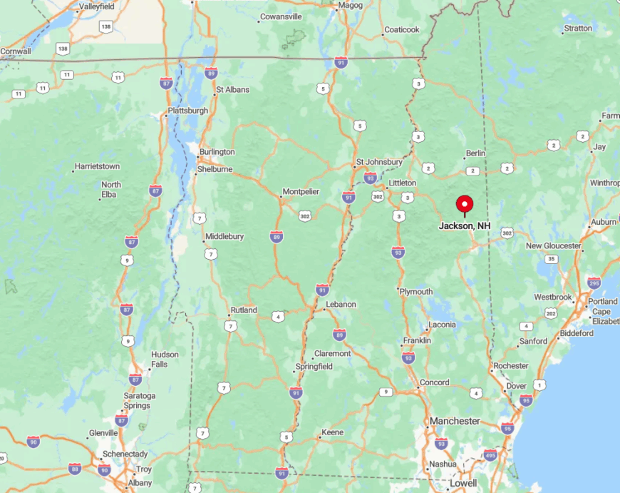
Jackson sits just off NH-16, about nine miles north of North Conway, nestled in a valley carved by the Ellis and Wildcat Rivers. The town’s compact cluster of inns and shops is ringed by gentle hills that transition quickly into the steep Carter Range.
Most visitors turn east onto Route 16A across the covered bridge, immediately sensing the slower pace. With no major highway slicing through, Jackson retains a hushed, village ambiance, yet remains accessible in under three hours from Boston.
1. Stewartstown – A Quiet Corner of the North Country
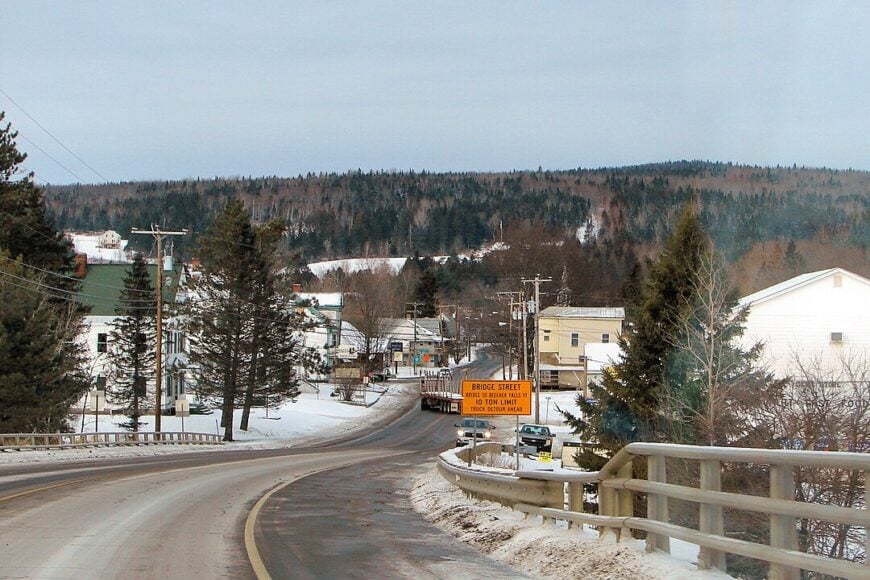
Stewartstown is the kind of place where time slows down. I like it for its rolling farmland, quiet roads, and the sense that life here is lived at a different rhythm, which brings me a lot of peace.
The town sits near the Connecticut River, offering peaceful waterfront views and easy access to fishing and boating. I always take a moment to watch the mist rise off the water in the early morning—it’s one of those simple pleasures that never gets old.
Stewartstown’s charm lies in its simplicity. There’s no rush here, just a steady appreciation for the land and the people who call it home. Stewartstown offers 2-4 bedroom homes priced between $64,000 and $175,000, making it one of the most affordable options in North New Hampshire.
Where is Stewartstown?
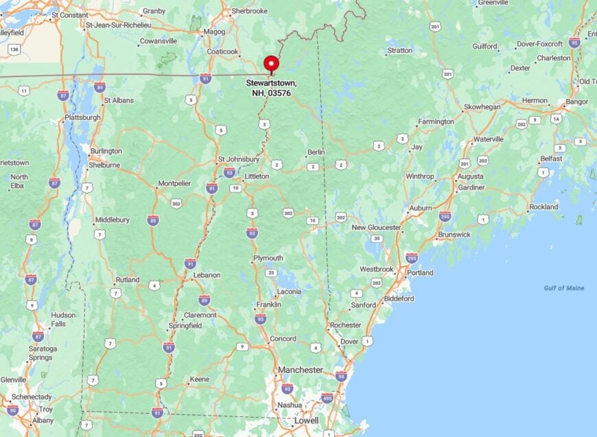
Stewartstown sits in Coös County, near the Vermont border, along US Route 3. The town is surrounded by rolling hills and quiet forests, giving it a peaceful, rural feel.
You can reach Stewartstown by following US-3 north from Colebrook or south from Pittsburg. The drive is relaxed, with open fields and distant mountain views guiding the way.