Best counties to live in Arkansas – based on a variety of criteria including median home prices
More counties in the United States experienced population growth in the last year, according to the latest Census data, even as pandemic-related moving trends begin to normalize.
Counties in the South continued to experience growth, particularly in Florida, where 96% of its 67 counties gained new residents. Polk County, Florida, a suburb of Orlando, added the most, with 26,000 people moving there in 2023.
Meanwhile, counties in the Midwest and Northeast continued to lose population, but at slower rates than the year before. Some of the biggest losses were in counties home to large cities, including Cook County, Illinois (home of Chicago) and the boroughs of Brooklyn and Queens in New York.
Many counties are experiencing growth due to their job opportunities, education, or relatively affordable housing costs. Others are favored for their historic or well-designed downtowns or access to cultural opportunities.
Stacker compiled a list of the best counties to live in Arkansas using rankings from Niche. Niche ranks counties by various factors including public schools, educational attainment, cost of living, and housing.
Keep reading to see if your county made the list.
You may also like: Healthy hotspots: The most physically active counties in Arkansas
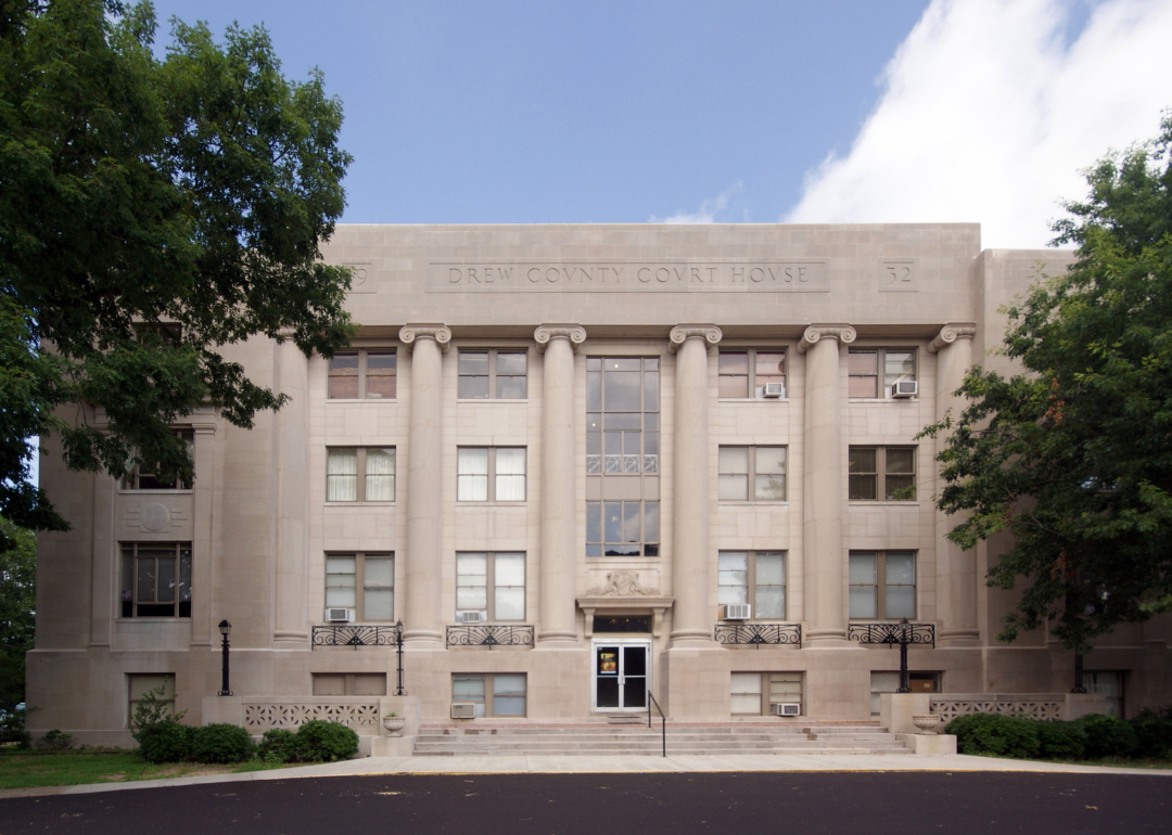
#30. Drew County, Arkansas
– Overall Rank: 1,388
– Population: 17,309
– Median household income: $44,968 (qualifying for a mortgage)
– Median home value: $123,900 (67% own)
– Median rent: $708 (33% rent)
– Top public schools: Monticello High School (grade C+), Monticello Intermediate School (grade C+), Monticello Middle School (grade C+)
– Top private schools: Monticello Christian Academy (grade unavailable)
– Top places: Monticello (grade B), Live Oak Township (grade B+), Winchester (grade B+)
About
Drew County offers a welcoming rural lifestyle supported by a stable economy rooted in agriculture, forestry, and education. Residents value its friendly atmosphere, low crime rate, and strong sense of community pride, making it appealing for those seeking a safe and grounded place to live.
The county provides access to quality public schools, healthcare services, and recreational areas, giving families a well-rounded environment for growth. Local parks, cultural landmarks, and seasonal events create opportunities for connection and leisure.
Housing ranges from modest single-family homes to properties with expansive acreage, attracting both first-time buyers and those seeking more space. With a low cost of living, steady property values, and a balanced pace of life, Drew County remains an inviting choice for long-term living.
Where is Drew County?
Drew County is located in southeastern Arkansas, approximately 100 miles southeast of Little Rock. The county is accessible via major routes such as U.S. Highway 425 and U.S. Highway 278, providing direct connections to nearby regions.
It is bordered by counties including Lincoln, Desha, and Ashley, and is anchored by Monticello, the largest city and county seat. The area offers convenient access to regional shopping, dining, and educational institutions, while remaining close to outdoor recreation opportunities in nearby parks and forests.
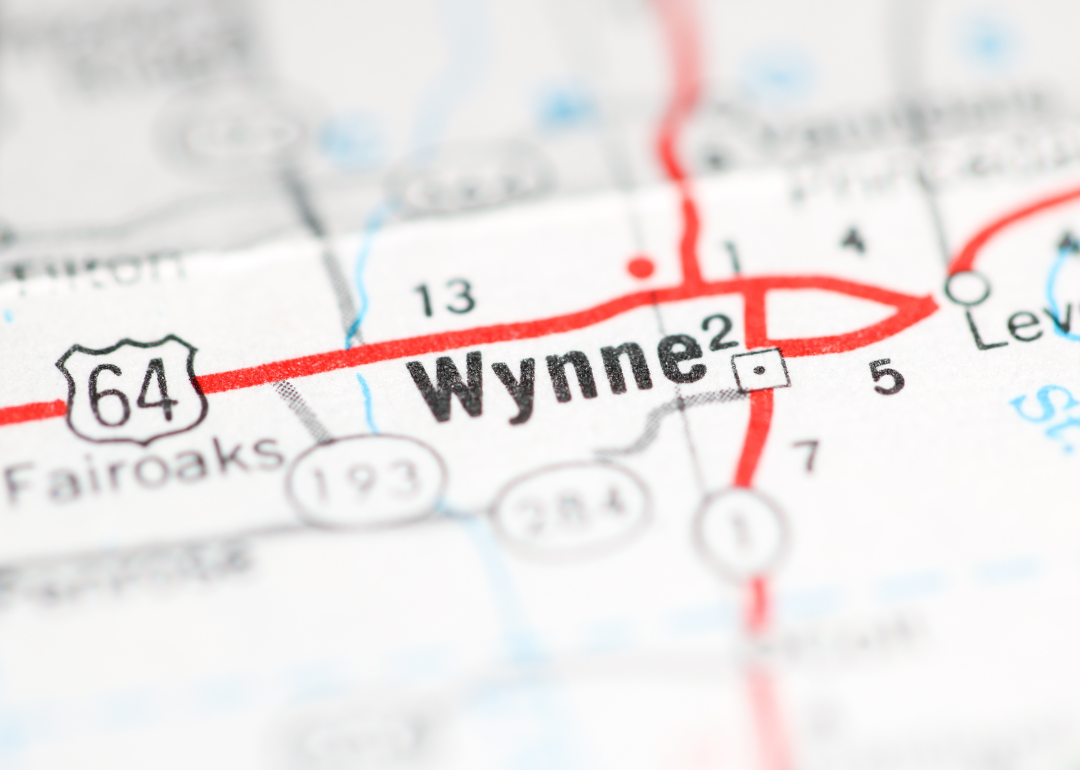
#29. Cross County, Arkansas
– Overall Rank: 1,387
– Population: 16,827
– Median household income: $48,129
– Median home value: $97,500 (66% own)
– Median rent: $815 (34% rent)
– Top public schools: Cross County Elementary Tech Academy (grade A minus), Cross County High School (grade B), Wynne High School (grade B)
– Top private schools:
– Top places: Wynne (grade C+), Ellis Township (grade B), Smith Township (grade B)
About
In eastern Arkansas, Cross County offers residents the stability of a rural community with the convenience of being within reach of larger markets. Agriculture remains a core industry, alongside manufacturing and service jobs that support the local economy.
The area attracts people looking for affordable living, dependable job prospects, and a community where neighbors look out for one another. `Quality schools, healthcare access, and a variety of outdoor spaces add to the county’s livability.
Whether choosing a traditional home in town or acreage in the countryside, residents benefit from property values that hold steady and a lifestyle rooted in balance and simplicity. Cross County continues to appeal to those seeking both opportunity and a slower pace.
Where is Cross County?
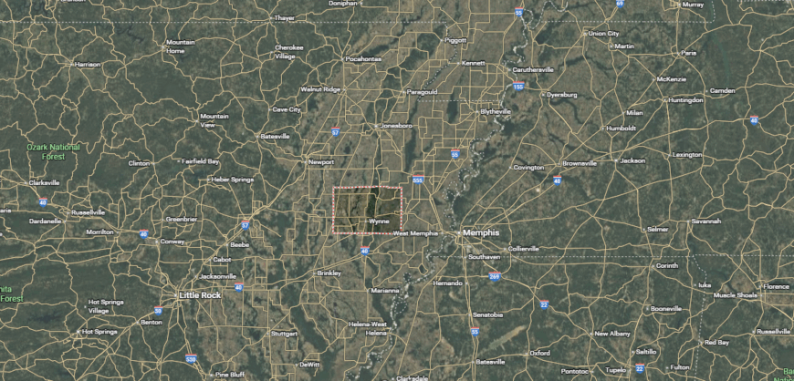
Cross County is located in eastern Arkansas, about 45 miles west of the Mississippi River and approximately 50 miles northeast of Little Rock. The county is served by major routes such as U.S. Highway 64 and U.S. Highway 49, which connect it to surrounding regions.
It is bordered by counties including St. Francis, Poinsett, and Woodruff, with Wynne serving as the largest city and county seat. The location offers access to regional shopping, dining, and services while being near outdoor attractions like Village Creek State Park and the Crowley’s Ridge Scenic Byway.
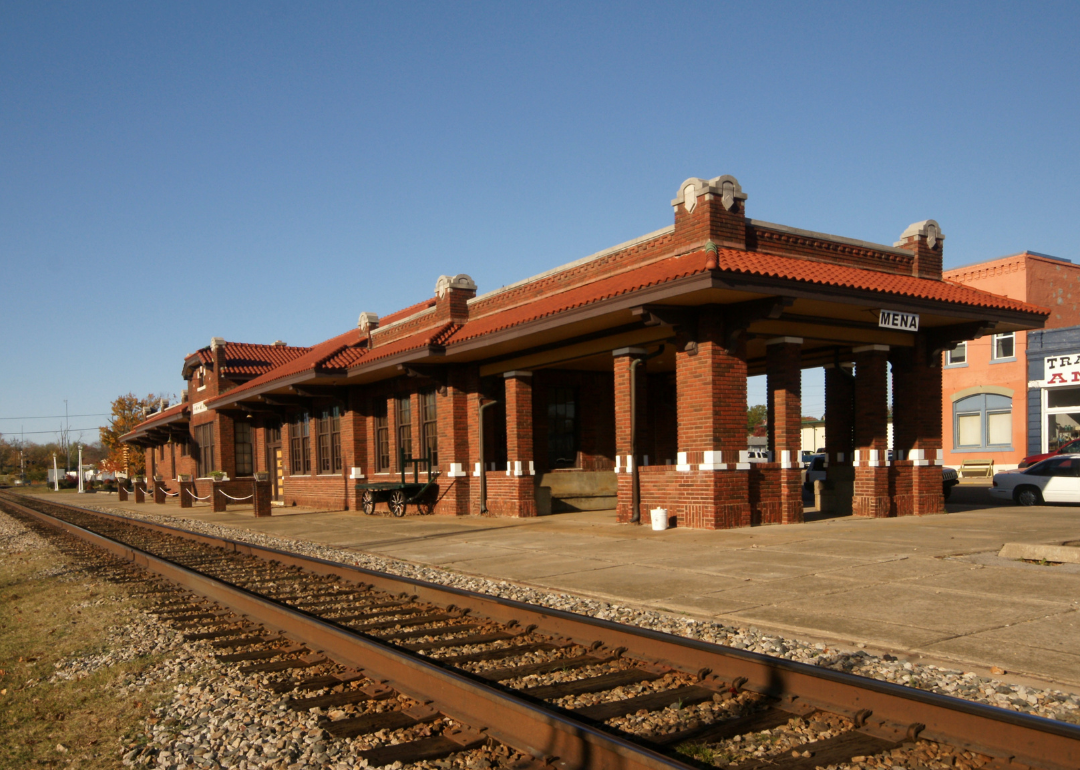
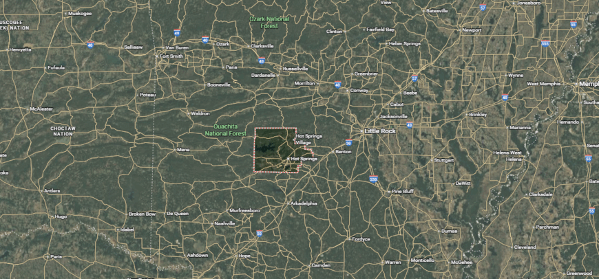
#28. Polk County, Arkansas
– Overall Rank: 1,373
– Population: 19,384
– Median household income: $48,449
– Median home value: $120,800 (80% own)
– Median rent: $730 (20% rent)
– Top public schools: Cossatot River Elementary School (grade B+), Mena Middle School (grade B), Holly Harshman Elementary School (grade B)
– Top private schools:
– Top places: Mena (grade B minus), Ozark Township (grade B+), Center Township (grade B)
About
Polk County in western Arkansas combines scenic mountain surroundings with a resilient, small-town economy. Timber, agriculture, and tourism provide steady employment, while local businesses and services meet most day-to-day needs. Many residents are drawn to the area for its affordable housing, access to nature, and strong community bonds.
The county supports its population with public schools, healthcare facilities, and recreational opportunities ranging from hiking trails to fishing lakes. Seasonal events and local markets add to its cultural life.
Home options vary from in-town residences to rural properties with acreage, appealing to both families and retirees. With a low cost of living, stable property values, and a quality of life shaped by both work and recreation, Polk County remains a practical and appealing place to settle.
Where is Polk County?
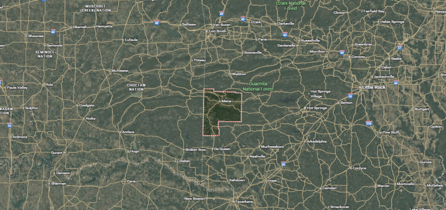
Polk County is located in western Arkansas along the border with Oklahoma, roughly 120 miles west of Little Rock. The county is accessible via U.S. Highways 71 and 270, offering direct routes to neighboring towns and regions.
It is bordered by counties such as Montgomery, Sevier, and Scott in Arkansas, as well as Le Flore County in Oklahoma, with Mena serving as the largest city and county seat. The area provides access to regional shopping, dining, and services while being close to outdoor destinations like the Ouachita National Forest and the Talimena Scenic Drive.
#27. Grant County, Arkansas
– Overall Rank: 1,303
– Population: 18,022
– Median household income: $68,598
– Median home value: $141,400 (80% own)
– Median rent: $802 (20% rent)
– Top public schools: Poyen Elementary School (grade B+), Sheridan High School (grade B), Sheridan Middle School (grade B)
– Top private schools:
– Top places: Sheridan (grade B), Poyen (grade B+), Simpson Township (grade B)

About
Grant County, located in central Arkansas, offers a blend of rural living and proximity to the Little Rock metropolitan area. Many residents commute for work in healthcare, manufacturing, and public service, while others are employed locally in agriculture and small businesses. This balance of opportunity and affordable living makes the county attractive to families and professionals alike.
Education is served by well-regarded public schools, and recreational options include community parks, fishing lakes, and organized sports. The area’s low crime rate and active civic organizations strengthen its reputation as a safe and engaged community.
From modest starter homes to properties with generous land, housing in Grant County fits a range of needs and budgets. With its combination of economic stability, accessible location, and family-friendly atmosphere, the county offers a comfortable place to build a future.
Where is Grant County?
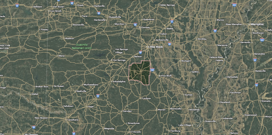
Grant County is located in central Arkansas, about 30 miles south of Little Rock. The county is served by major routes including U.S. Highway 167 and State Highway 35, providing convenient connections to nearby cities and regions.
It is bordered by counties such as Saline, Jefferson, and Hot Spring, with Sheridan as the largest city and county seat. The area offers access to shopping, dining, and services while being near outdoor recreation spots like Jenkins Ferry State Park and parts of the Saline River.
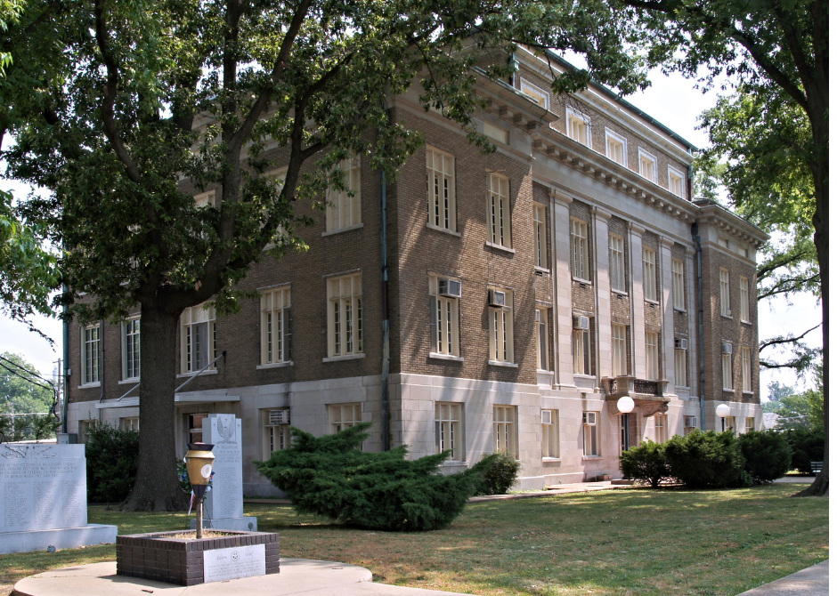
#26. Miller County, Arkansas
– Overall Rank: 1,278
– Population: 42,682
– Median household income: $47,613
– Median home value: $137,700 (66% own)
– Median rent: $831 (34% rent)
– Top public schools: Genoa Central Elementary School (grade A minus), Gary E. Cobb Middle School (grade A minus), Genoa Central High School (grade B)
– Top private schools: Trinity Christian School (grade B+)
– Top places: Texarkana (grade B), Garland Township (grade B+), Cleveland Township (grade B minus)
You may also like: Counties with the most tornadoes in Arkansas
About
Bordering Texas and Louisiana, Miller County blends the character of a small-town community with the reach of a tri-state economy. Its position along major highways and rail lines fuels industries like logistics, manufacturing, and retail trade. Residents often choose the area for its job variety, competitive housing costs, and access to urban amenities without losing a close-knit feel.
Recreation is part of daily life here, with lakes, parks, and trails providing year-round options for fishing, boating, and outdoor gatherings. Public schools and medical facilities meet core needs, while local events strengthen neighborhood connections.
From downtown Texarkana properties to open countryside homesteads, housing reflects a range of lifestyles. Steady property values, a diverse job market, and a community that balances work with leisure make Miller County an enduring choice for long-term living.
Where is Miller County?
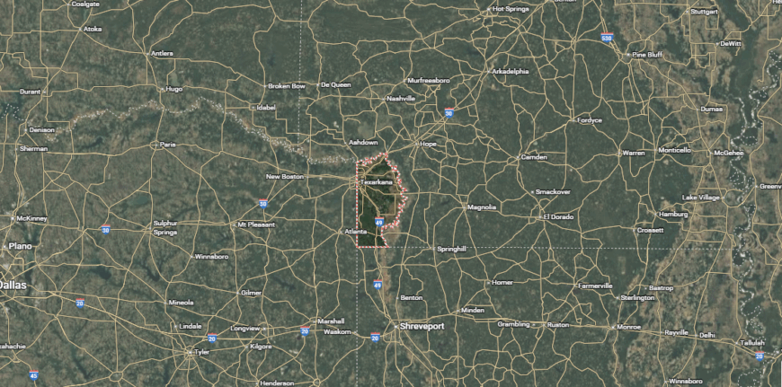
Miller County sits at the southwestern tip of Arkansas, where the state meets Texas and Louisiana. Interstate 49 and U.S. Highways 67, 71, and 82 run through the area, linking it to nearby cities and regional hubs.
Texarkana serves as the county seat, positioned along the state line and offering a mix of urban amenities and cross-state connections. The surrounding landscape includes access to Millwood Lake, the Sulphur River Wildlife Management Area, and other outdoor destinations.
#25. Woodruff County, Arkansas
– Overall Rank: 1,271
– Population: 6,259
– Median household income: $49,608
– Median home value: $96,100 (69% own)
– Median rent: $582 (31% rent)
– Top public schools: McCrory Elementary School (grade A minus), McCrory High School (grade B), Augusta High School (grade C+)
– Top private schools:
– Top places: McCrory (grade B+), Patterson (grade B+), De View Township (grade B)
About
Woodruff County, in eastern Arkansas, is shaped by its strong agricultural base, with row crops and livestock production driving much of the local economy. Small businesses and public service jobs add stability, creating a dependable environment for both workers and families. Many residents choose the county for its affordability, open spaces, and slower pace of life.
Life here is centered on community gatherings, local festivals, and outdoor activities such as hunting and fishing. Public schools and healthcare services ensure essential needs are met, while nearby regional centers expand access to shopping and specialized care.
Housing options range from historic homes in small towns to rural properties with acreage. With low living costs, a strong farming tradition, and a close-knit social fabric, Woodruff County offers a grounded and practical place to put down roots.
Where is Woodruff County?
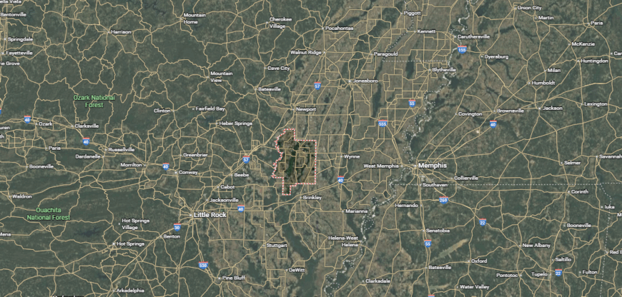
Woodruff County lies in the east-central part of Arkansas, within the rich farmland of the Arkansas Delta. State Highways 33, 38, and 64 pass through the county, connecting its towns to nearby commercial and cultural centers.
Augusta serves as the county seat, situated along the White River and offering a historic downtown core. The area is surrounded by agricultural landscapes, with opportunities for hunting, fishing, and exploring the region’s waterways and bottomland forests.
#24. Izard County, Arkansas
– Overall Rank: 1,258
– Population: 13,748
– Median household income: $46,159
– Median home value: $110,600 (77% own)
– Median rent: $616 (23% rent)
– Top public schools: Melbourne Elementary School (grade B+), Melbourne High School (grade B), Calico Rock High School (grade B minus)
– Top private schools:
– Top places: Drytown Township (grade A minus), Mill Creek Township (grade B+), Lacrosse Township (grade B+)
About
Surrounded by the Ozark Mountains, Izard County offers abundant opportunities for fishing, hiking, and boating, making the outdoors a central part of daily life. Seasonal festivals and community events add to its small-town character while connecting residents across the area.
The county’s housing market ranges from modest in-town homes to larger rural properties, with affordability and steady values attracting both new buyers and long-term residents. Agriculture, healthcare, education, and local commerce form a stable employment base, ensuring access to work close to home.
Schools, clinics, and essential services are available locally, with larger amenities just a short drive away in regional hubs. With its mix of natural beauty, reliable economic support, and a strong sense of community, Izard County offers a balanced lifestyle that appeals to many.
Where is Izard County?
Izard County is situated in north-central Arkansas, within the Ozark Mountain region. U.S. Highway 62/412 and State Highways 9 and 56 provide connections to neighboring counties and regional destinations. Melbourne, the county seat, serves as the primary hub for government services, local commerce, and education.
The surrounding terrain features rolling hills, rivers, and forests, with access to outdoor activities such as fishing on the White River and hiking in nearby Ozark National Forest areas.
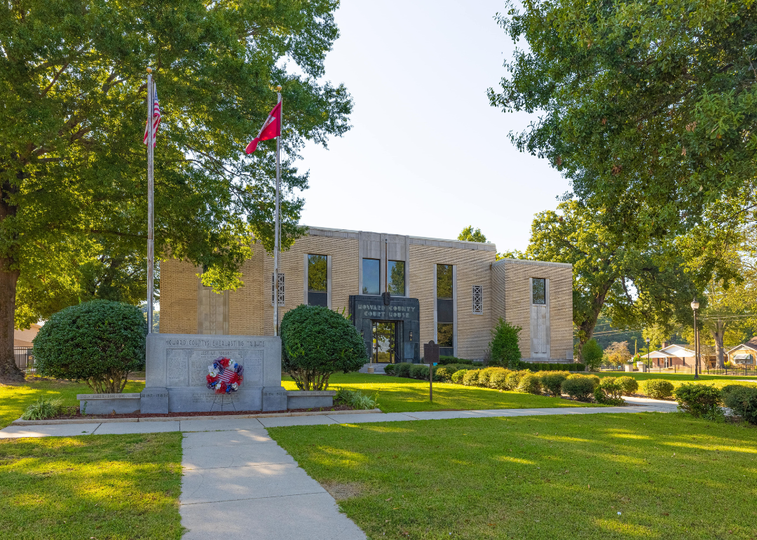
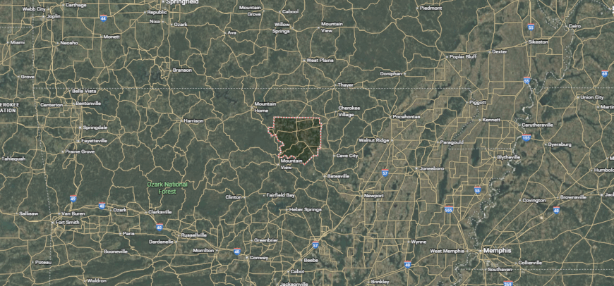
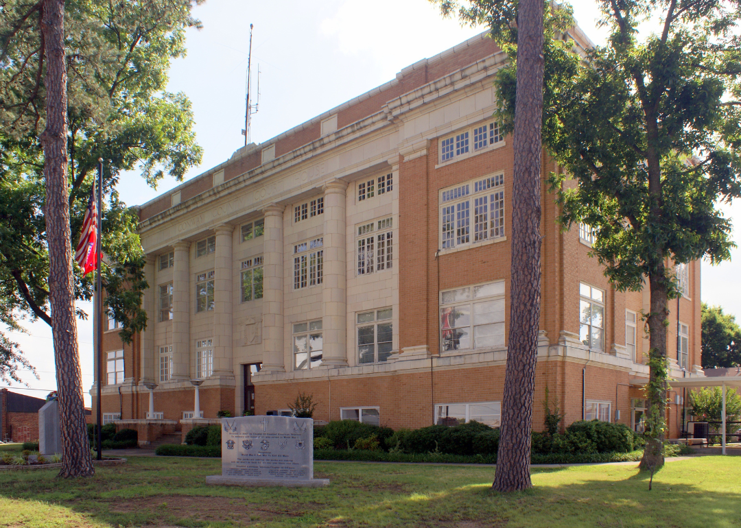
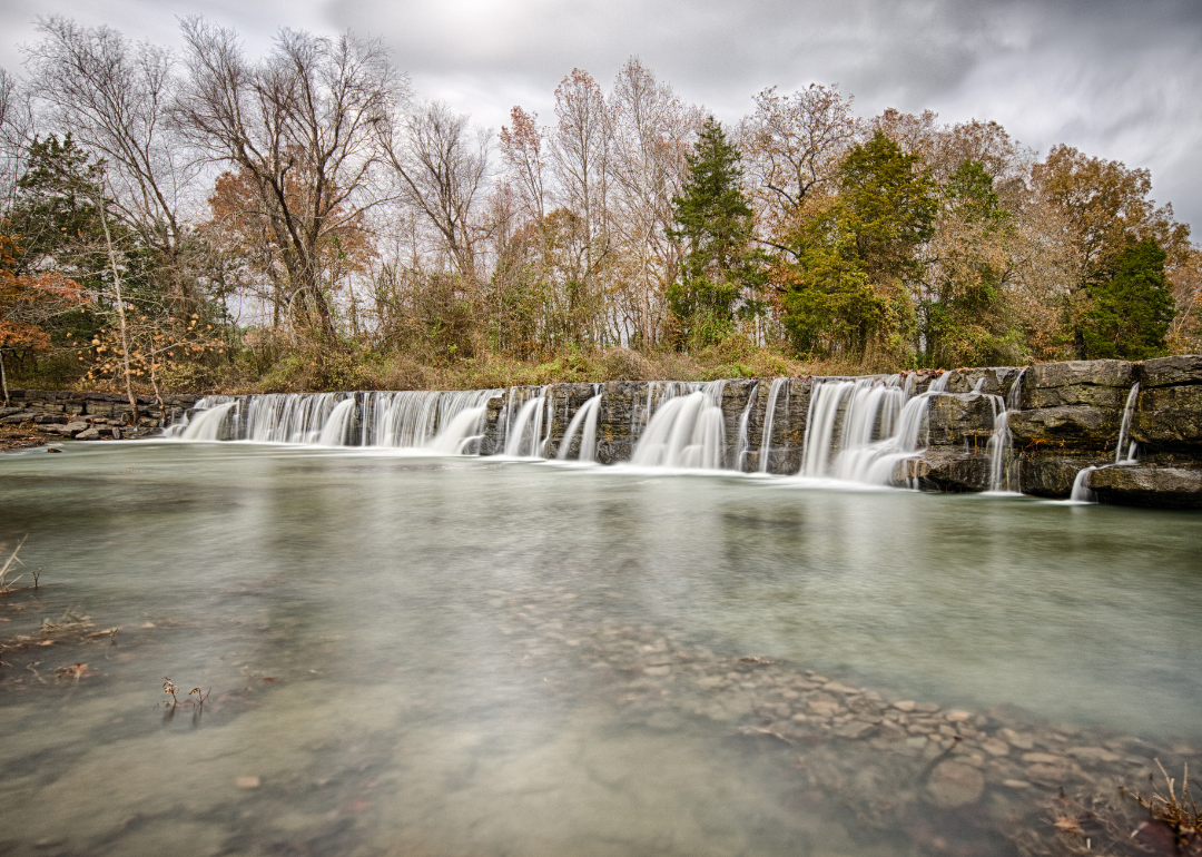
#23. Howard County, Arkansas
– Overall Rank: 1,171
– Population: 12,779
– Median household income: $44,824
– Median home value: $125,300 (73% own)
– Median rent: $732 (27% rent)
– Top public schools: Nashville Elementary School (grade A minus), Umpire K-12 School (grade B+), Nashville Primary School (grade B+)
– Top private schools: Nashville Christian Academy (grade unavailable), UMPIRE CHRISTIAN SCHOOL (grade unavailable)
– Top places: Nashville (grade B minus), Buck Range Township (grade B+), Center Point Township (grade B+)
About
Howard County’s economy is anchored by poultry production, timber, and manufacturing, providing steady employment and supporting a low cost of living. Many residents value the chance to work close to home while benefiting from a quieter, more affordable lifestyle.
Outdoor recreation plays a big role here, with nearby lakes, trails, and hunting areas drawing both locals and visitors. Community events, fairs, and school activities foster strong neighborhood connections.
Housing options include everything from modest single-family homes in town to rural properties with acreage. With reliable job opportunities, accessible amenities, and a pace of life that encourages connection, Howard County remains a practical and appealing choice for long-term living.
Where is Howard County?
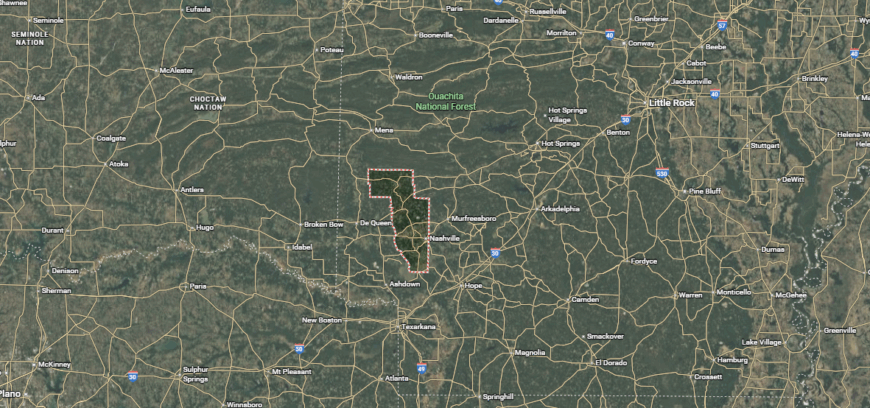
Howard County is located in southwest Arkansas, in a region known for its mix of farmland, forests, and rolling hills. U.S. Highway 278 and State Highways 27 and 355 link its communities to surrounding towns and economic centers.
Nashville serves as the county seat, functioning as the main hub for local commerce, schools, and services. The area offers access to outdoor recreation at places like Lake Greeson and the Cossatot River, as well as scenic drives through the Ouachita foothills.
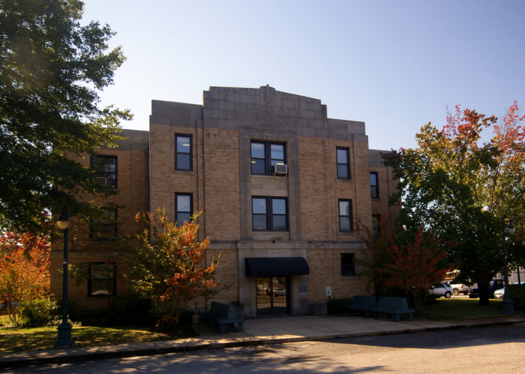
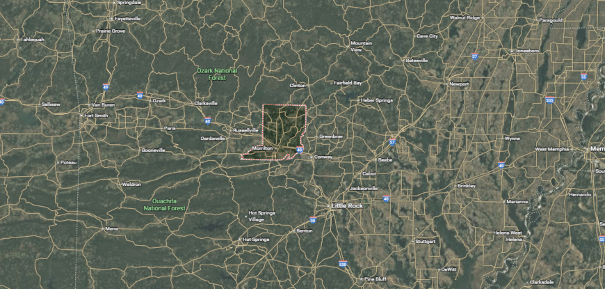
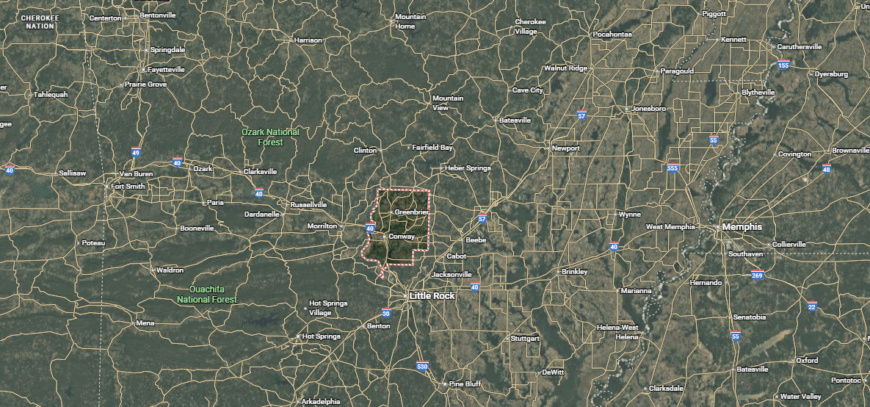
#22. Conway County, Arkansas
– Overall Rank: 1,122
– Population: 20,782
– Median household income: $50,282
– Median home value: $129,600 (68% own)
– Median rent: $698 (32% rent)
– Top public schools: Nemo Vista Middle School (grade A minus), Nemo Vista High School (grade B), Morrilton Intermediate School (grade B)
– Top private schools: Sacred Heart Catholic School (grade C+), Riverview Baptist Christian School (grade unavailable)
– Top places: Morrilton (grade B), Cedar Falls Township (grade A), Center Ridge (grade B+)
About
Bordered by the Arkansas River and nestled in the foothills of the Ozarks, Conway County offers abundant outdoor opportunities, from hiking trails to fishing and boating. Local festivals, farmers’ markets, and cultural events give residents ways to stay connected throughout the year.
The housing market includes a mix of in-town residences, suburban neighborhoods, and rural acreage, with prices that remain accessible to a wide range of buyers. Agriculture, manufacturing, healthcare, and education form the backbone of the economy, creating stable job options for locals.
Public schools, medical services, and essential shopping are available within the county, while proximity to larger cities expands access to specialized amenities. Combining natural beauty, economic steadiness, and a welcoming atmosphere, Conway County provides a well-rounded setting for both work and leisure.
Where is Conway County?
Conway County is positioned in central Arkansas, bordered by the Arkansas River to the south and the Ozark Mountains to the north. Interstate 40 and U.S. Highway 64 cross the county, providing direct routes to Little Rock and other regional destinations.
Morrilton serves as the county seat, offering a central location for business, education, and community events. The area includes access to Petit Jean State Park, the Arkansas River Valley, and scenic drives through the surrounding mountain landscape.
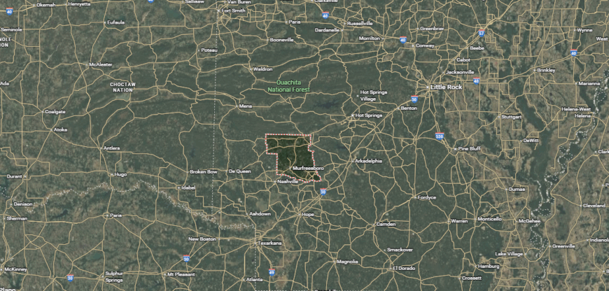
#21. Pike County, Arkansas
– Overall Rank: 1,117
– Population: 10,205
– Median household income: $49,248
– Median home value: $99,200 (75% own)
– Median rent: $657 (25% rent)
– Top public schools: Centerpoint Elementary School (grade B+), Murfreesboro Elementary School (grade B), Kirby High School (grade B)
– Top private schools: Glenwood Christian School (grade unavailable)
– Top places: Muddy Fork Township (grade A), Antoine Township (grade B+), White Township (grade B+)
You may also like: How gas prices have changed in Arkansas in the last week
About
Pike County, Arkansas is a rural community known for its scenic beauty, with rolling hills, forests, and rivers defining the landscape. Outdoor recreation is a major draw, offering fishing, camping, hiking, and boating at destinations like Lake Greeson and the Little Missouri River.
Small towns throughout the county provide essential services, local shops, and schools that foster close community connections. The local economy is supported by agriculture, timber, and tourism, particularly at Crater of Diamonds State Park where visitors can search for real gemstones.
Housing options range from modest homes in town to larger properties with acreage. With its natural surroundings and laid-back pace, Pike County attracts those who value space, quiet, and outdoor living.
Where is Pike County?
Pike County is in southwest Arkansas, where the Ouachita Mountains meet rolling river valleys. U.S. Highways 70 and 371 provide routes through the county, connecting its communities to nearby towns and attractions.
Murfreesboro, the county seat, is best known as the gateway to Crater of Diamonds State Park, a unique public diamond mine. The surrounding area features clear rivers, forested hills, and recreation spots like Lake Greeson and the Little Missouri River.
#20. Arkansas County, Arkansas
– Overall Rank: 1,090
– Population: 17,024
– Median household income: $58,695
– Median home value: $125,900 (66% own)
– Median rent: $749 (34% rent)
– Top public schools: Dewitt Middle School (grade B+), Dewitt Elementary School (grade B), Dewitt High School (grade B)
– Top private schools: Grand Prairie Evangelical Methodist School (grade B+), St. John’s Lutheran School (grade unavailable), Holy Rosary Catholic School (grade unavailable)
– Top places: Stuttgart (grade B), DeWitt (grade B minus), Bayou Meto Township (grade A)
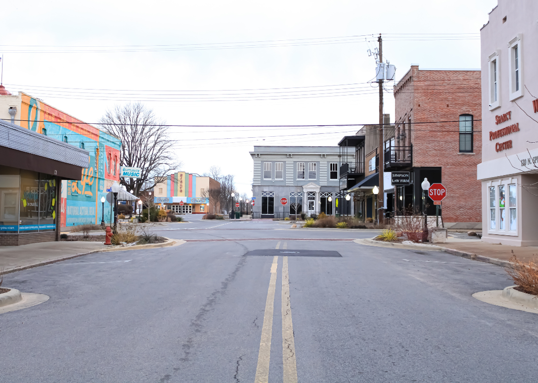
About
Arkansas County, Arkansas sits at the heart of the Delta, where expansive farmland meets winding rivers and rich wetlands. It holds a unique place in state history as one of the earliest settled regions, with a legacy tied to agriculture and river trade.
The fertile soil sustains crops like rice and soybeans, while its waterways are prized for duck hunting, fishing, and boating. Towns such as Stuttgart and DeWitt anchor the community, offering local markets, schools, and events that draw residents together.
Life here moves at a steady rhythm, shaped by the seasons and the land, giving the county a character that’s both rooted and resilient.
Where is Arkansas County?
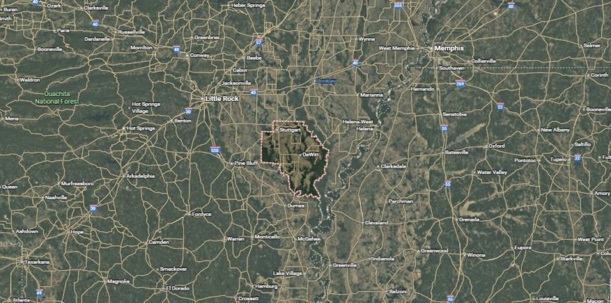
Arkansas County is located in the east-central part of the state, spanning both the Arkansas Delta and Grand Prairie regions. U.S. Highways 79 and 165 run through the county, linking its communities to regional trade and travel routes.
Stuttgart and DeWitt serve as dual county seats, each acting as a hub for government, commerce, and cultural events. The landscape includes expansive farmland, the White River National Wildlife Refuge, and numerous opportunities for hunting, fishing, and birdwatching.
#19. White County, Arkansas
– Overall Rank: 1,087
– Population: 77,118
– Median household income: $51,144
– Median home value: $150,700 (66% own)
– Median rent: $793 (34% rent)
– Top public schools: Ahlf Junior High School (grade A), Westside Elementary School (grade A minus), Southwest Middle School (grade A minus)
– Top private schools: Harding Academy (grade A minus), Crosspointe Preparatory (grade A minus), Liberty Christian School (grade unavailable)
– Top places: Searcy (grade A minus), Beebe (grade B), Judsonia (grade B)
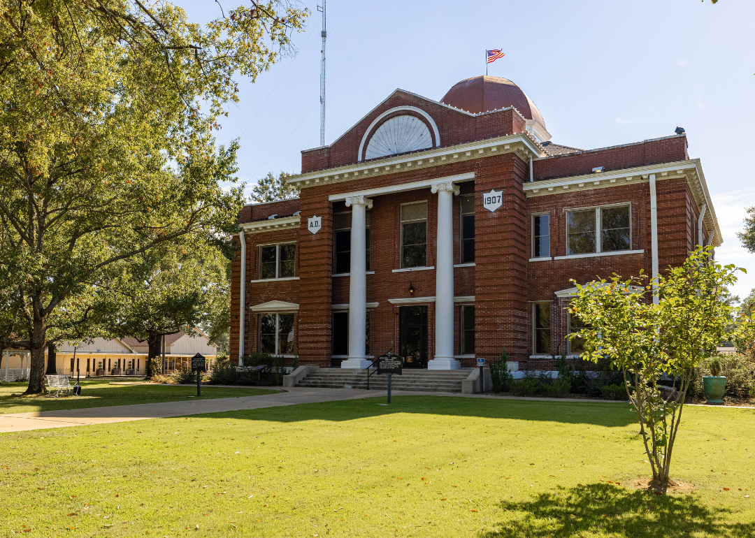
About
White County, Arkansas combines the energy of a regional hub with the comfort of small-town living. Anchored by the city of Searcy, the county is home to higher education institutions, a diverse economy, and a growing business community.
Surrounding areas feature farmland, forests, and rivers, offering space for outdoor activities like fishing, hiking, and camping. Residents enjoy a mix of cultural amenities, local festivals, and community events alongside easy access to everyday services.
Housing ranges from in-town neighborhoods to rural properties with acreage. This balance of opportunity, natural beauty, and community spirit makes White County a welcoming place to live and work.
Where is White County?
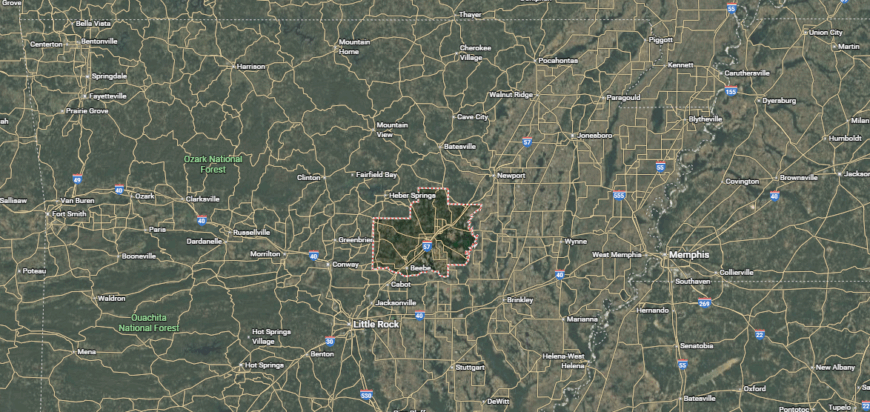
White County is situated in north-central Arkansas, with a landscape that blends farmland, rivers, and small-town communities. U.S. Highways 64, 67, and 167 provide major travel corridors through the area, connecting it to Little Rock and other parts of the state.
Searcy serves as the county seat and is a center for education, healthcare, and local commerce. The county offers access to outdoor recreation along the Little Red River, as well as parks, trails, and nearby Greers Ferry Lake.
#18. Little River County, Arkansas
– Overall Rank: 1,062
– Population: 12,024
– Median household income: $58,627
– Median home value: $108,200 (84% own)
– Median rent: $683 (16% rent)
– Top public schools: Oscar Hamilton Elementary School (grade B+), Ashdown High School (grade B minus), Margaret Daniels Primary School (grade B minus)
– Top private schools: New Faith Tabernacle Academy (grade unavailable)
– Top places: Ashdown (grade B+), Jeff Davis Township (grade B+), Jackson Township (grade B+)
About
Little River County, Arkansas rests in the far southwest corner of the state, bordered by Texas and Oklahoma. Its landscape features a mix of farmland, pine forests, and waterways, including Millwood Lake and the Little River, which provide opportunities for fishing, boating, and wildlife viewing.
Agriculture, timber, and manufacturing form the backbone of the local economy, while small towns like Ashdown serve as community centers with schools, shops, and local events.
Residents value the area’s quiet pace and wide-open spaces, with housing options ranging from modest homes to larger rural properties. The county’s blend of natural resources and close community ties offers a lifestyle rooted in both work and recreation.
Where is Little River County?
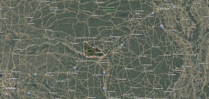
Little River County sits in the far southwest corner of Arkansas, bordered by Texas to the west and Oklahoma to the north. U.S. Highways 59, 71, and 82 cross the county, providing direct links to regional trade and travel routes.
Ashdown, the county seat, serves as the main hub for business, government, and community life. The area is known for its proximity to Millwood Lake, the Little River, and numerous opportunities for fishing, boating, and wildlife viewing.
#17. Mississippi County, Arkansas
– Overall Rank: 1,032
– Population: 40,361
– Median household income: $50,012
– Median home value: $110,000 (60% own)
– Median rent: $750 (40% rent)
– Top public schools: Armorel Elementary School (grade A minus), Buffalo Island Central East Elementary School (grade A minus), Gosnell Elementary School (grade A minus)
– Top private schools: The Delta School (grade unavailable)
– Top places: Gosnell (grade B), Manila (grade B), Blytheville (grade B minus)
About
Mississippi County, Arkansas sits in the state’s northeastern corner, where the Mississippi River shapes both the landscape and the economy. Vast stretches of Delta farmland support crops like soybeans, cotton, and rice, while major steel mills and manufacturing plants add a strong industrial base.
Blytheville and Osceola anchor the county with schools, healthcare, and cultural events, while smaller communities maintain a close-knit feel. Outdoor opportunities range from river fishing to exploring wildlife refuges that attract migratory birds.
Homes vary from established neighborhoods in town to farmsteads surrounded by open fields. The county’s mix of agriculture, industry, and natural beauty creates a setting where work, community, and the outdoors are closely connected.
Where is Mississippi County?
Mississippi County is located in the northeastern corner of Arkansas along the Mississippi River. Interstate 55 and U.S. Highways 61 and 63 run through the county, connecting it to Memphis, St. Louis, and other regional centers.
Blytheville and Osceola serve as dual county seats, each providing government services, commerce, and cultural activities. The area features rich agricultural land, riverfront access, and nearby wildlife areas, along with industrial hubs tied to steel production and transportation.
#16. Crawford County, Arkansas
– Overall Rank: 1,031
– Population: 60,593
– Median household income: $56,702
– Median home value: $154,900 (76% own)
– Median rent: $789 (24% rent)
– Top public schools: Parkview Elementary School (grade A minus), Northridge Middle School (grade A minus), Oliver Springs Elementary (grade A minus)
– Top private schools:
– Top places: Van Buren (grade A minus), Alma (grade B minus), Van Buren Township (grade A minus)
You may also like: Best public colleges in Arkansas
About
Crawford County, Arkansas rests in the state’s northwest, where the Ozark Mountains meet the Arkansas River Valley. The terrain blends wooded hills, fertile valleys, and riverfronts, offering scenery that draws hikers, anglers, and campers.
Featuring a historic downtown district, local businesses, and community events that highlight the area’s heritage. Agriculture, light manufacturing, and retail support the economy, while Interstate 40 provides convenient access to larger cities.
Neighborhoods range from suburban developments to rural homesteads with acreage. With its mix of natural landscapes, historic charm, and strategic location, Crawford County offers both a relaxed pace and easy connections to the wider region.
Where is Crawford County?
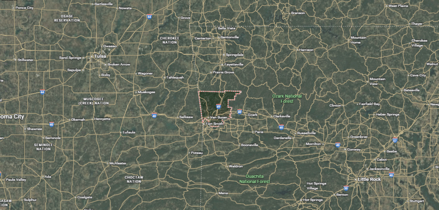
Crawford County is in western Arkansas, bordered by the Arkansas River to the south and the Oklahoma state line to the west. Interstate 40, Interstate 49, and U.S. Highways 64 and 71 pass through the county, making it a key transportation crossroads in the region.
Van Buren serves as the county seat, with a historic downtown and access to commercial, cultural, and recreational amenities. The area includes scenic stretches of the Ozark National Forest, along with rivers, trails, and state parks.
#15. Lonoke County, Arkansas
– Overall Rank: 1,003
– Population: 74,292
– Median household income: $68,078
– Median home value: $169,600 (72% own)
– Median rent: $944 (28% rent)
– Top public schools: Mountain Springs Elementary School (grade A minus), Cabot Freshman Academy (grade A minus), Cabot Junior High North (grade A minus)
– Top private schools: New Horizon Academy (grade unavailable)
– Top places: Austin (grade A), Cabot (grade A minus), Ward (grade B+)
About
Lonoke County, Arkansas lies just east of Little Rock, combining rural landscapes with the convenience of nearby urban amenities. Known for its rich farmland, the county produces rice, soybeans, and other crops, while also supporting a growing residential community.
Lonoke, Cabot, and other towns serve as hubs for schools, shopping, and local events, fostering strong community connections. Outdoor enthusiasts enjoy fishing and boating at local lakes and wildlife areas, as well as hunting and nature viewing.
Housing options range from in-town neighborhoods to larger properties with acreage. The county’s blend of agriculture, small-town life, and proximity to the capital makes it an appealing place to live and work.
Where is Lonoke County?
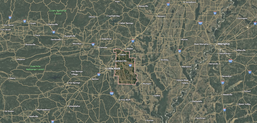
Lonoke County is located in central Arkansas, east of Little Rock and within the Arkansas Delta region. Interstate 40 and U.S. Highways 67 and 70 run through the county, providing quick connections to the state capital and neighboring areas.
Lonoke serves as the county seat, while Cabot and England are other key communities offering commerce, schools, and local services. The area is known for its agricultural production, access to Bayou Meto Wildlife Management Area, and proximity to both rural landscapes and urban amenities.
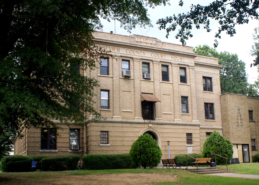
#14. Sevier County, Arkansas
– Overall Rank: 848
– Population: 15,913
– Median household income: $53,567
– Median home value: $99,200 (65% own)
– Median rent: $700 (35% rent)
– Top public schools: Dequeen Junior High School (grade A minus), Dequeen High School (grade A minus), Dequeen Elementary School (grade A minus)
– Top private schools: Legacy Academy (grade unavailable)
– Top places: De Queen (grade B+), Bear Creek Township (grade B+), Gillham (grade B)
About
In southwest Arkansas, Sevier County offers a setting where farmland, timberland, and waterways shape daily life. The Little River and Cossatot River provide space for fishing, kayaking, and weekend camping, while De Queen Lake is a favorite for boating and swimming.
De Queen anchors the county with schools, medical services, and local events, while surrounding communities keep a strong rural identity. Poultry farming and agriculture drive much of the economy, supported by small manufacturing operations.
Residential choices range from compact homes in town to wide-acre homesteads in the countryside. Life here moves with the seasons, tied closely to the land and the community’s shared traditions.
Where is Sevier County?
Sevier County is located in southwest Arkansas, along the Oklahoma border, in a region known for its forests, farmland, and rivers. It is accessible via major roads including U.S. Highways 70, 71, and 59, which connect it to nearby towns and regional hubs.
The county is bordered by Howard, Little River, and Polk counties in Arkansas, and McCurtain County in Oklahoma, with De Queen serving as the largest city and county seat, offering convenient access to shopping, dining, and local services.
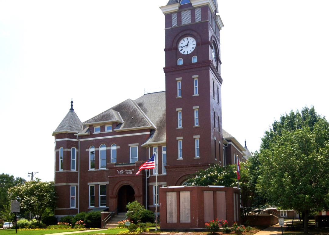
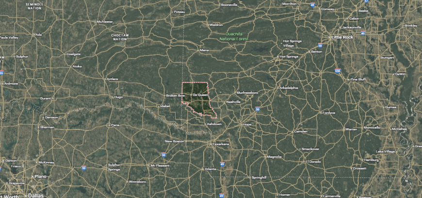
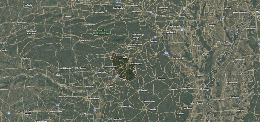
#13. Clark County, Arkansas
– Overall Rank: 823
– Population: 21,469
– Median household income: $48,071
– Median home value: $143,300 (62% own)
– Median rent: $690 (38% rent)
– Top public schools: Arkadelphia High School (grade C+), Gurdon High School (grade C+), Peake Elementary School (grade C+)
– Top private schools: Clark County Christian Academy (grade unavailable)
– Top places: Arkadelphia (grade B), Caddo Valley (grade B+), Caddo Township (grade B+)
About
Clark County, Arkansas is a place where the rivers carve the land and the community builds its rhythm around them. From quiet mornings along the Ouachita and Caddo to the hum of college life in Arkadelphia, the county balances wide-open spaces with an active local scene.
Agriculture thrives in its valleys, while small industries and two universities sustain year-round activity. Trails, lakes, and forested hills give residents plenty of room to roam, whether for weekend hikes or afternoon fishing trips.
Homes vary from downtown residences to rural acreage tucked between fields and woods. It’s a county where the landscape, learning, and local spirit are all part of daily life.
Where is Clark County?
Clark County is located in south-central Arkansas, within the Ouachita Mountains region and the Arkansas Timberlands. It is accessible via Interstate 30 and U.S. Highways 67 and 371, providing direct routes to Little Rock, Texarkana, and surrounding areas.
The county is bordered by Hot Spring, Dallas, Pike, and Nevada counties, with Arkadelphia serving as the largest city and county seat. The area offers access to shopping, dining, and educational institutions, as well as nearby outdoor destinations like DeGray Lake Resort State Park and the Ouachita National Forest.
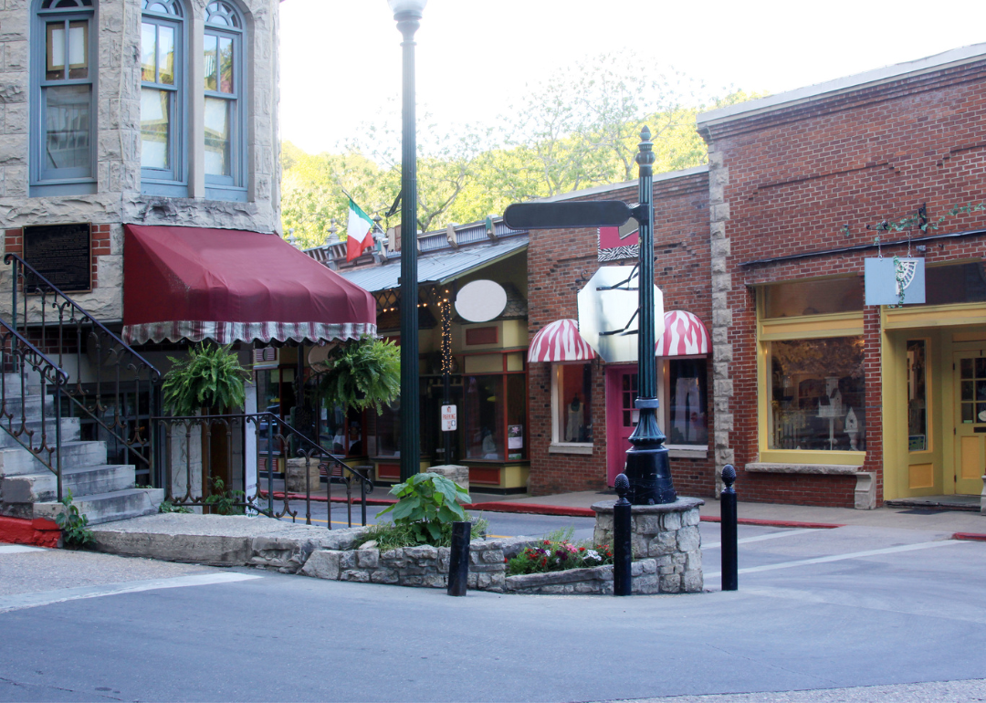
#12. Carroll County, Arkansas
– Overall Rank: 787
– Population: 28,362
– Median household income: $56,826
– Median home value: $169,700 (76% own)
– Median rent: $751 (24% rent)
– Top public schools: Green Forest Elementary School (grade B+), Eureka Springs High School (grade B), Eureka Springs Elementary School (grade B)
– Top private schools: Clear Spring School (grade unavailable), The Academy of Excellence (grade unavailable)
– Top places: Berryville (grade B), Green Forest (grade B minus), Prairie Township (grade A minus)
About
In Carroll County, Arkansas, the Ozarks set the stage with ridges, hollows, and streams winding through its towns and countryside. Eureka Springs draws visitors with its winding streets, Victorian buildings, and year-round arts scene, while Berryville keeps a steady pace as the county’s commercial center.
Beyond the towns, the Kings River and nearby lakes offer fishing, paddling, and quiet places to camp. Local livelihoods mix farming, tourism, and independent trades, giving the area both seasonal buzz and day-to-day stability.
From tucked-away cabins to farms spread across rolling pastures, the county’s homes reflect its blend of mountain seclusion and community connection.
Where is Carroll County?
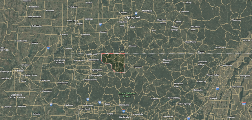
Carroll County is located in northwestern Arkansas, within the Ozark Mountains. It is accessible via U.S. Highways 62, 412, and 65, which connect it to nearby cities and tourist destinations. The county is bordered by Boone, Madison, Benton, and Newton counties in Arkansas, and Barry and Stone counties in Missouri.
Berryville and Eureka Springs serve as dual county seats, with the area offering shopping, dining, and access to outdoor attractions like Beaver Lake, the Kings River, and the Ozark National Forest.
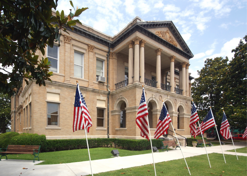
#11. Columbia County, Arkansas
– Overall Rank: 755
– Population: 22,707
– Median household income: $47,441
– Median home value: $123,200 (72% own)
– Median rent: $690 (28% rent)
– Top public schools: Emerson Elementary School (grade A), Taylor Elementary School (grade A), Taylor High School (grade A)
– Top private schools: Columbia Christian School (grade A minus)
– Top places: Magnolia (grade B), Emerson (grade A minus), McNeil (grade A minus)
You may also like: Risky reservoirs: Arkansas counties where aging dams pose the greatest threat
About
Columbia County, Arkansas rests in the southwest corner of the state, where pine forests and open fields stretch between small towns. Magnolia, the county seat, anchors the area with Southern Arkansas University, local festivals, and a busy courthouse square.
Timber, agriculture, and manufacturing form the backbone of the economy, while oil production remains part of its history. Lakes, hunting grounds, and wooded trails give residents a mix of weekend escapes and everyday recreation.
Neighborhoods range from shaded streets near downtown to wide-acre properties beyond the city limits. Life here is tied to the land, the school calendar, and the steady pulse of a close-knit community.
Where is Columbia County?
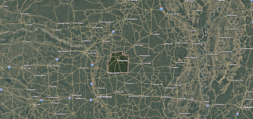
Columbia County is located in south-central Arkansas, near the Louisiana border. It is accessible via U.S. Highways 79, 82, and 371, which connect it to regional trade and travel routes. The county is bordered by Union, Nevada, and Lafayette counties in Arkansas, as well as Webster Parish in Louisiana.
Magnolia serves as the county seat and largest city, offering shopping, dining, and cultural events, along with proximity to outdoor recreation areas such as Logoly State Park and Lake Columbia.
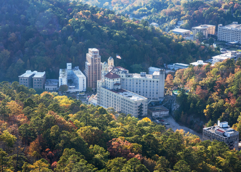
#10. Garland County, Arkansas
– Overall Rank: 638
– Population: 100,021
– Median household income: $54,229
– Median home value: $166,600 (68% own)
– Median rent: $913 (32% rent)
– Top public schools: Arkansas School for Mathematics, Sciences, and the Arts (grade A+), Lakeside Intermediate School (grade A), Lakeside High School (grade A)
– Top private schools: Gospel Light Christian School (grade B+), Christian Ministries Academy (grade C), St. John Elementary School (grade unavailable)
– Top places: Hot Springs (grade B+), Rockwell (grade B), Piney (grade B)

About
Garland County, Arkansas is shaped by water and hills, with Hot Springs National Park at its heart. The city of Hot Springs draws visitors year-round to its historic bathhouses, thermal springs, and lively downtown, while surrounding areas offer quiet neighborhoods and wooded retreats.
Three large lakes—Hamilton, Catherine, and Ouachita—create endless options for boating, fishing, and waterfront living. Tourism drives much of the economy, supported by health services, small industry, and local businesses.
Scenic byways lead into the Ouachita Mountains, where hiking and camping are part of everyday life for many residents. From lakefront homes to mountain hideaways, the county offers a blend of recreation, history, and natural beauty that’s hard to match.
Where is Garland County?
Garland County is located in central Arkansas, within the Ouachita Mountains region. It is accessible via U.S. Highways 70 and 270, as well as Interstate 30, providing connections to Little Rock and surrounding areas.
The county is bordered by Saline, Hot Spring, Montgomery, and Perry counties, with Hot Springs serving as the county seat and largest city. The area is known for its natural hot springs, numerous lakes, and access to outdoor recreation in Hot Springs National Park and the Ouachita National Forest.
#9. Union County, Arkansas
– Overall Rank: 551
– Population: 38,815
– Median household income: $49,745
– Median home value: $110,900 (73% own)
– Median rent: $775 (27% rent)
– Top public schools: Parkers Chapel Elementary School (grade A minus), Hugh Goodwin Elementary School (grade A minus), Smackover Elementary School (grade B+)
– Top private schools: West Side Christian School (grade A minus), Maranatha Baptist Christian School (grade unavailable)
– Top places: El Dorado (grade B+), Boone Township (grade A), El Dorado Township (grade B+)
Union County, Arkansas sits along the state’s southern border, where forested hills meet stretches of farmland. El Dorado serves as the economic and cultural center, known for its restored downtown, music festivals, and historic neighborhoods.
Oil production has shaped much of the county’s history and still plays a role in its economy, alongside manufacturing, timber, and agriculture. Residents have access to outdoor spaces like the Felsenthal National Wildlife Refuge, offering fishing, hunting, and birdwatching.
Homes range from century-old residences in town to secluded properties on wooded acreage. The county blends industrial heritage, community pride, and a landscape that supports both work and recreation.
Where is Union County?
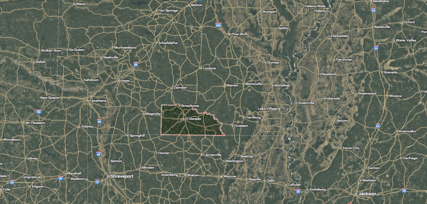
Union County is located in south-central Arkansas, along the Louisiana border. It is accessible via U.S. Highways 82, 167, and 63, which link it to regional trade centers and neighboring states. The county is bordered by Columbia, Ouachita, and Calhoun counties in Arkansas, as well as Union and Morehouse parishes in Louisiana.
El Dorado serves as the county seat and largest city, offering shopping, dining, and cultural events, with nearby opportunities for outdoor recreation at places like Moro Bay State Park and the Felsenthal National Wildlife Refuge.
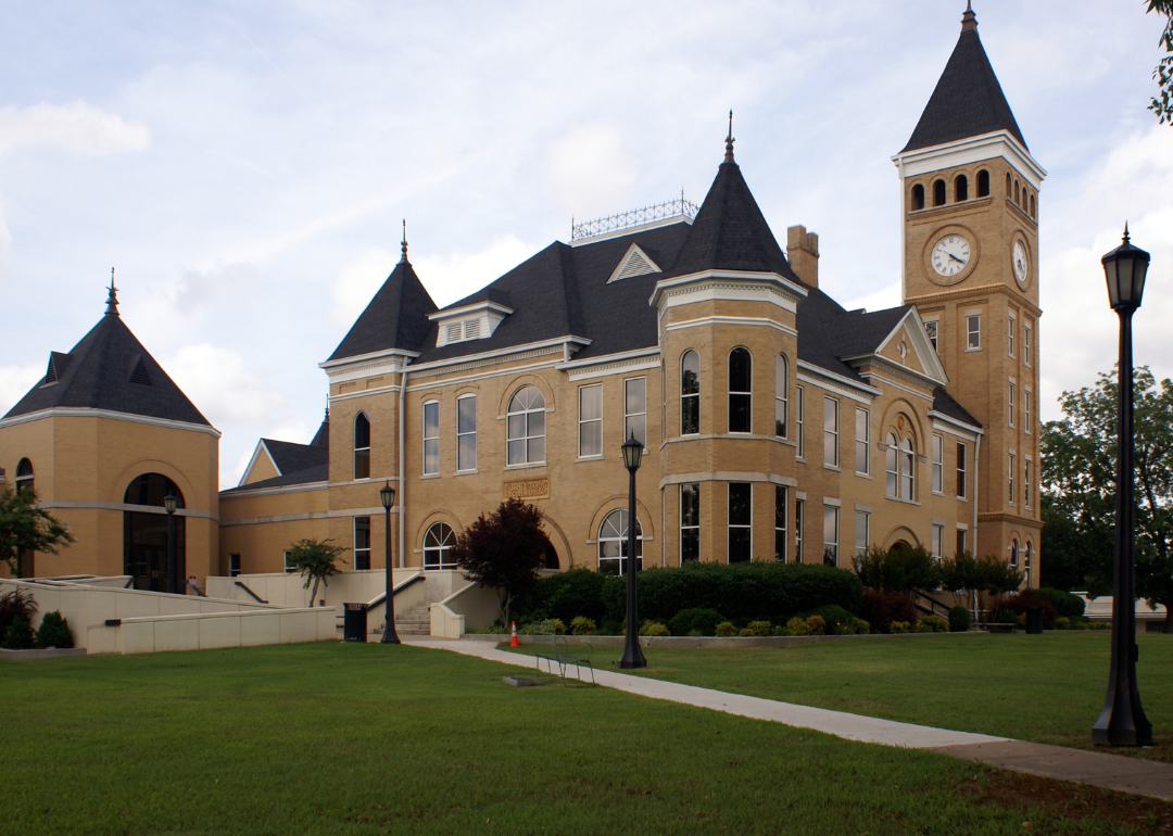
#8. Pope County, Arkansas
– Overall Rank: 474
– Population: 63,475
– Median household income: $51,678
– Median home value: $152,000 (72% own)
– Median rent: $810 (28% rent)
– Top public schools: Center Valley Elementary School (grade A), Sequoyah Elementary School (grade A), Pottsville Elementary School (grade A)
– Top private schools: Valley Christian School (grade B+), St. John Catholic School (grade unavailable)
– Top places: Russellville (grade A), Pottsville (grade A minus), Illinois Township (grade A minus)
About
Pope County, Arkansas sits where the Arkansas River cuts through the foothills of the Ozarks, offering both fertile valleys and rugged highlands. Russellville anchors the county with a university, a thriving business district, and access to Lake Dardanelle State Park.
The local economy draws strength from manufacturing, education, and outdoor tourism, with hiking, fishing, and boating all within easy reach. Scenic drives lead into the Ozark National Forest, where trails wind through forests and mountain overlooks.
Residential areas range from riverfront neighborhoods to rural homesteads tucked into the hills. Life here is shaped by a balance of natural beauty, economic opportunity, and a strong sense of place.
Where is Pope County?
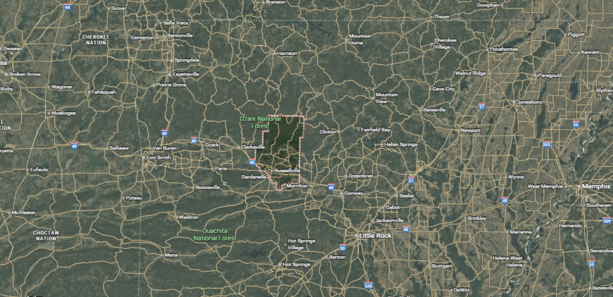
Pope County is located in north-central Arkansas, bordered by the Arkansas River to the south and the Ozark Mountains to the north. It is accessible via Interstate 40 and U.S. Highways 64 and 27, providing connections to Little Rock, Fort Smith, and surrounding communities.
The county is bordered by Johnson, Conway, Van Buren, and Yell counties, with Russellville serving as the county seat and largest city. The area offers shopping, dining, and educational opportunities, along with outdoor recreation at Lake Dardanelle State Park and the Ozark–St. Francis National Forest.
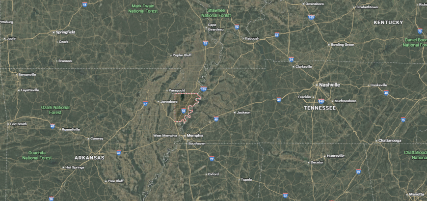
#7. Craighead County, Arkansas
– Overall Rank: 303
– Population: 111,038
– Median household income: $55,169
– Median home value: $182,600 (60% own)
– Median rent: $870 (40% rent)
– Top public schools: Valley View Elementary School (grade A), Brookland Elementary School (grade A minus), Valley View Junior High School (grade A minus)
– Top private schools: Ridgefield Christian School (grade A minus), Blessed Sacrament School (grade unavailable), Montessori School of Jonesboro (grade unavailable)
– Top places: Jonesboro (grade B+), Brookland (grade B+), Gilkerson Township (grade A minus)
About
Craighead County, Arkansas is a thriving hub in the northeast, where fertile farmland meets a growing urban center. Jonesboro, the county seat, is home to Arkansas State University, a busy medical district, and a variety of shopping, dining, and cultural venues.
Agriculture remains important in the surrounding countryside, with rice, soybeans, and cotton fields stretching to the horizon. Residents enjoy nearby parks, golf courses, and access to Crowley’s Ridge for hiking and scenic drives.
Neighborhoods range from established in-town blocks to newer developments and rural properties. The county’s blend of higher education, industry, and open land creates a community that’s both forward-moving and firmly rooted in its regional heritage.
Where is Craighead County?
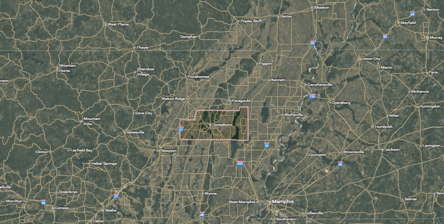
Craighead County is located in northeastern Arkansas, within the Arkansas Delta region. It is accessible via major routes including Interstate 555 and U.S. Highways 49, 63, and 67, connecting it to Memphis, Little Rock, and surrounding areas.
The county is bordered by Greene, Poinsett, Jackson, and Lawrence counties, with Jonesboro serving as the county seat and largest city. The area features a mix of urban amenities, agricultural land, and access to outdoor recreation at places like Craighead Forest Park and Lake Frierson State Park.
#6. Saline County, Arkansas
– Overall Rank: 300
– Population: 123,988
– Median household income: $73,236
– Median home value: $194,400 (78% own)
– Median rent: $948 (22% rent)
– Top public schools: Bethel Middle School (grade A), Benton High School (grade A), Perrin Elementary School (grade A)
– Top private schools: Arkansas Christian Academy (grade C), Avilla Christian Academy (grade unavailable), Our Lady of Fatima Catholic School (grade unavailable)
– Top places: Bryant (grade A), Alexander (grade A), Salem (grade A minus)
You may also like: How opioid prescriptions to Medicaid patients in Arkansas stack up

About
Saline County, Arkansas lies just southwest of Little Rock, offering a mix of suburban growth and rural landscapes. Benton and Bryant serve as the main population centers, each with strong school systems, local parks, and community events that draw residents together.
The county’s economy blends retail, healthcare, manufacturing, and commuting access to the capital, giving it both stability and opportunity. Rivers, lakes, and nearby Ouachita Mountain trails provide space for fishing, boating, and weekend hikes.
Housing ranges from suburban neighborhoods to country homes with acreage. With its balance of convenience, outdoor access, and community life, Saline County appeals to a wide range of residents.
Where is Saline County?
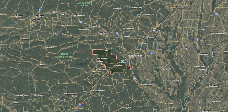
Saline County is located in central Arkansas, just southwest of Little Rock. It is accessible via Interstate 30 and U.S. Highways 67, 70, and 167, which provide direct connections to the state capital and surrounding regions.
The county is bordered by Pulaski, Garland, Grant, Hot Spring, and Perry counties, with Benton serving as the county seat and largest city. The area offers a blend of suburban and rural communities, along with access to shopping, dining, and outdoor recreation at nearby parks, lakes, and the Ouachita Mountains.
#5. Pulaski County, Arkansas
– Overall Rank: 241
– Population: 398,322
– Median household income: $58,326
– Median home value: $187,600 (58% own)
– Median rent: $985 (42% rent)
– Top public schools: Central High School (grade A), LISA Academy North Middle-High School – High School (grade A), Maumelle Charter Elementary School (grade A)
– Top private schools: Pulaski Academy (grade A+), The Episcopal Collegiate School (grade A+), Little Rock Christian Academy (grade A)
– Top places: Hillcrest (grade A+), River Mountain (grade A+), Downtown (grade A+)

About
Pulaski County, Arkansas is the state’s most populous and urbanized county, anchored by Little Rock, the capital city. It serves as Arkansas’s political, cultural, and economic center, home to state government, major businesses, hospitals, and universities.
The Arkansas River runs through the heart of the county, with trails, parks, and waterfront attractions connecting neighborhoods to downtown. Beyond the city, suburban communities and rural areas offer a range of living environments, from historic districts to new developments.
The economy thrives on government, healthcare, education, and commerce, while museums, theaters, and music venues add to its cultural depth. Pulaski County’s mix of urban vibrancy and nearby natural spaces creates a setting where opportunity and lifestyle intersect.
Where is Pulaski County?
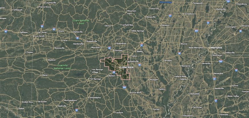
Pulaski County is located in central Arkansas and serves as the state’s most populous county. It is accessible via Interstates 30, 40, and 430, as well as U.S. Highways 67 and 70, providing extensive regional and interstate connections.
The county is bordered by Saline, Lonoke, Faulkner, and Perry counties, with Little Rock as both the county seat and the state capital. The area offers a full range of urban amenities, cultural attractions, and employment centers, along with access to the Arkansas River, Pinnacle Mountain State Park, and other outdoor destinations.
#4. Faulkner County, Arkansas
– Overall Rank: 191
– Population: 124,611
– Median household income: $61,273
– Median home value: $195,800 (62% own)
– Median rent: $931 (38% rent)
– Top public schools: Greenbrier Middle School (grade A), Conway High School (grade A), Greenbrier Springhill Elementary School (grade A)
– Top private schools: Conway Christian School (grade A minus), St. Joseph School (grade B+), COMPASS ACADEMY (grade unavailable)
– Top places: Conway (grade A), Greenbrier (grade A minus), Mayflower (grade B+)
About
Faulkner County, Arkansas sits in central Arkansas, where fast-growing communities meet stretches of farmland and rolling hills. Conway, the county seat, is known for its three colleges, giving the area a strong educational presence and a steady flow of cultural events.
Technology, education, and healthcare lead the local economy, while nearby lakes and parks provide space for fishing, hiking, and camping. Interstate access makes commuting to Little Rock convenient, yet the county maintains its own identity through local festivals, farmers markets, and community gatherings.
Housing options range from in-town neighborhoods to rural properties with acreage. The mix of academic influence, economic opportunity, and outdoor access shapes a community that’s both dynamic and grounded.
Where is Faulkner County?
Faulkner County is located in central Arkansas, north of Little Rock in the Arkansas River Valley. It is accessible via Interstate 40 and U.S. Highways 64 and 65, which connect it to the capital and surrounding regions. The county is bordered by Conway, White, Pulaski, and Perry counties, with Conway serving as the county seat and largest city.
The area features a mix of suburban growth and rural landscapes, along with access to higher education institutions, shopping, dining, and outdoor recreation at Lake Conway and Cadron Settlement Park.
#3. Sebastian County, Arkansas
– Overall Rank: 165
– Population: 128,184
– Median household income: $54,047
– Median home value: $154,900 (60% own)
– Median rent: $805 (40% rent)
– Top public schools: Greenwood Junior High School (grade A), Westwood Elementary School (grade A), East Pointe Elementary School (grade A)
– Top private schools: Union Christian Academy (grade A), Immaculate Conception Elementary School (grade unavailable), Christ the King Catholic School (grade unavailable)
– Top places: Greenwood (grade A), Fort Smith (grade A minus), Barling (grade A minus)
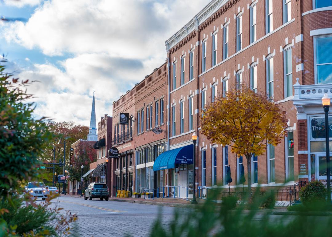
About
Sebastian County, Arkansas spans the Arkansas River Valley at the state’s western edge, bordered by Oklahoma. Fort Smith, the largest city, anchors the county with a rich frontier history, a diverse economy, and a lively downtown district.
Manufacturing, healthcare, and transportation drive much of the local industry, while nearby military installations add to its economic base. Parks, trails, and riverfront spaces offer places for walking, cycling, and community events, with the Ouachita and Ozark Mountains within a short drive.
Smaller towns in the county maintain a quieter pace, balancing the urban energy of Fort Smith. From historic neighborhoods to new developments, Sebastian County blends heritage, growth, and easy access to outdoor recreation.
Where is Sebastian County?
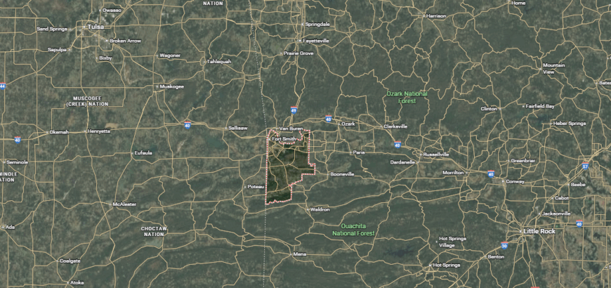
Sebastian County is located in western Arkansas, along the Oklahoma border in the Arkansas River Valley. It is accessible via Interstates 40 and 540, as well as U.S. Highways 71 and 271, providing direct routes to regional and interstate destinations. The county is bordered by Crawford, Franklin, and Logan counties in Arkansas, and Le Flore and Sequoyah counties in Oklahoma.
Fort Smith serves as the largest city and one of two county seats, offering extensive commerce, cultural venues, and access to outdoor recreation along the Arkansas River and in nearby mountain areas.
#2. Washington County, Arkansas
– Overall Rank: 123
– Population: 247,331
– Median household income: $61,985
– Median home value: $235,500 (55% own)
– Median rent: $935 (45% rent)
– Top public schools: Haas Hall Academy Jones Center (Springdale) (grade A+), Haas Hall Academy (grade A+), Hellstern Middle School (grade A)
– Top private schools: Shiloh Christian School (grade A), Fayetteville Christian School (grade A minus), The New School (grade B+)
– Top places: Johnson (grade A+), Fayetteville (grade A), Elm Springs (grade A)
About
Washington County, Arkansas lies in the heart of the Ozarks, where rolling hills meet a fast-growing urban corridor. Fayetteville serves as the county seat and is home to the University of Arkansas, giving the area a vibrant mix of academics, arts, and Razorback sports.
The local economy thrives on education, healthcare, technology, and a strong corporate presence from nearby Northwest Arkansas companies. Trails, parks, and scenic drives connect residents to the surrounding mountains, while a lively downtown scene offers music, dining, and year-round events.
Smaller towns like Prairie Grove and West Fork keep a more rural feel, with farmland and wooded valleys nearby. The county’s combination of cultural energy and natural beauty creates a community that’s both progressive and deeply rooted in the Ozark landscape.
Where is Washington County?
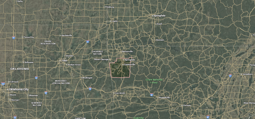
Washington County is located in northwest Arkansas, within the Ozark Mountains. It is accessible via Interstate 49 and U.S. Highways 62, 71, and 412, which connect it to nearby cities and regional hubs. The county is bordered by Benton, Madison, and Crawford counties in Arkansas, as well as Adair County in Oklahoma.
Fayetteville serves as the county seat and largest city, offering a mix of cultural attractions, educational institutions, and access to outdoor recreation in the surrounding mountain landscapes.
#1. Benton County, Arkansas
– Overall Rank: 35
– Population: 286,528
– Median household income: $85,269
– Median home value: $254,000 (68% own)
– Median rent: $1,113 (32% rent)
– Top public schools: Haas Hall Academy at the Lane (Rogers) (grade A+), Fulbright Junior High School (grade A+), Evening Star Elementary School (grade A+)
– Top private schools: Thaden School (grade A+), Ozark Adventist Academy (grade A minus), Providence Classical Christian Academy (grade A minus)
– Top places: Bentonville (grade A+), Cave Springs (grade A+), Centerton (grade A+)
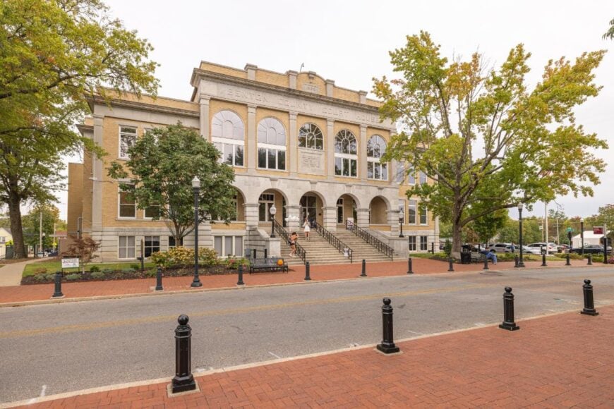
About
Benton County, Arkansas anchors the state’s northwest corner, where rapid growth meets the natural beauty of the Ozarks. Bentonville, the county seat, is known for its role as Walmart’s headquarters, a thriving arts scene, and the world-class Crystal Bridges Museum of American Art.
The county’s economy is fueled by corporate offices, retail, manufacturing, and a strong entrepreneurial community. Lakes, parks, and trails—including the Razorback Greenway—draw cyclists, hikers, and boaters year-round.
Surrounding towns like Rogers, Bella Vista, and Siloam Springs offer their own mix of neighborhoods, schools, and local events. With its blend of economic opportunity, cultural amenities, and outdoor recreation, Benton County has become one of Arkansas’s most dynamic and connected regions.
Where is Benton County?
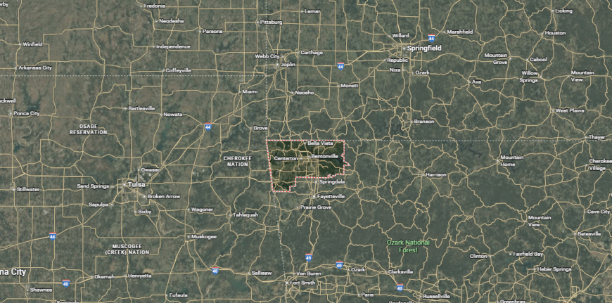
Benton County is located in the far northwest corner of Arkansas, along the Missouri and Oklahoma borders. It is accessible via Interstate 49 and U.S. Highways 62, 71, and 412, which link it to regional and interstate destinations.
The county is bordered by Washington and Carroll counties in Arkansas, McDonald County in Missouri, and Delaware and Adair counties in Oklahoma. Bentonville serves as the county seat, with the area offering a mix of urban amenities, cultural attractions, and outdoor recreation at Beaver Lake and in the Ozark Mountains.
This story features data reporting and writing by Elena Cox and is part of a series utilizing data automation across 50 states.
You may also like: Counties with the most homes selling under list price in Arkansas
By Stacker