
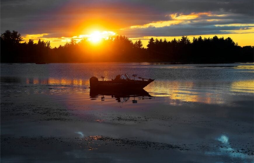
The northeastern corner of Michigan’s Lower Peninsula is rich with spruce ridges, cedar swamps, and forgotten rail beds that time never really caught. Tucked among the hardwoods are tiny communities where nights are pitch-black, traffic lights are nonexistent, and the loudest evening sound might be a barred owl.
We gathered 25 of those towns, each offering elbow room, dark skies, and a pace that fits a pocket watch better than a smartphone. Every stop on the countdown keeps big-box bustle at arm’s length while surrounding residents with rivers, lakes, and forestland that still feel wild.
Whether a traveler seeks a quiet cabin weekend or a long-term homestead, these spots prove that wide-open silence still exists below the Mackinac Bridge.
25. Hillman – Riverside Quiet Where Elk Still Roam
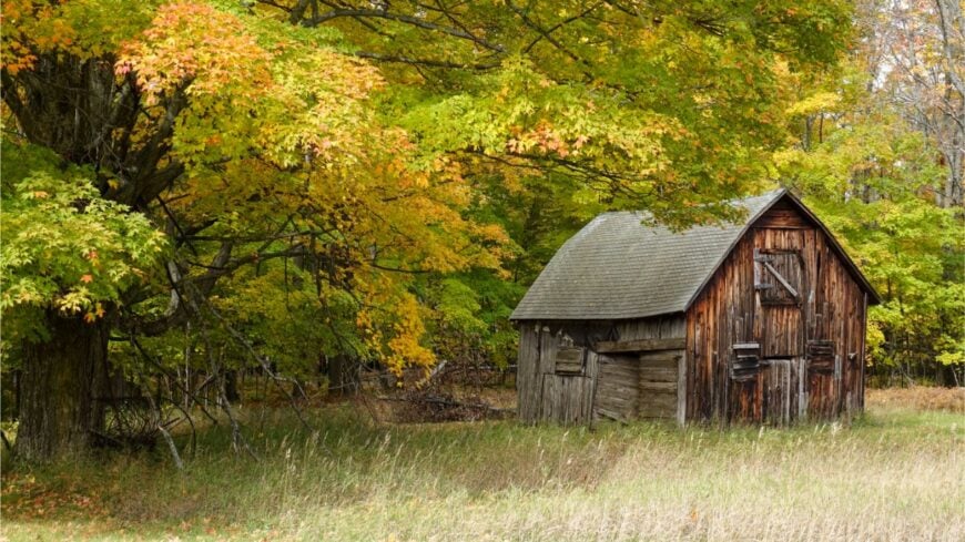
Hillman is a place where the Thunder Bay River curls through farm fields and forest edges, far from the speed of interstates. With only a few hundred residents, the town’s rhythm is set by the sound of water over the old mill dam and the bugle of elk echoing from the surrounding state forest.
💼🏠 When the CEO of the biggest real estate brokerage on the planet speaks about buying or selling, it’s worth listening. Hear what Robert Refkin has to say.
Travelers linger at the covered bridge park, drift-fish for trout, or ride the long, scenic trails that weave through the surrounding hills. Local livelihoods come from small businesses, farming, and seasonal outdoor tourism, but the town keeps its modest, unhurried feel.
Nights here settle softly, with porch lights glowing like fireflies against the dark countryside. It’s the kind of place where even time seems to walk instead of run.
Where is Hillman?
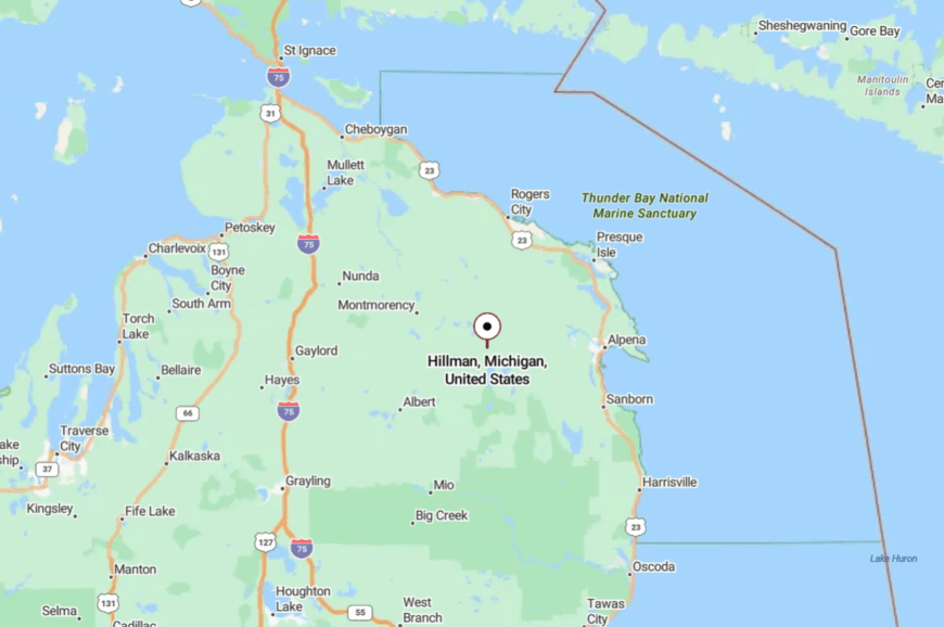
Hillman sits in Montmorency County in northeast Michigan, about 22 miles west of Alpena. It’s reached by M-32, a two-lane highway that cuts through rolling farmland and hardwood stands.
There’s no nearby interstate, just quiet country miles leading you in. By the time you arrive, the pace of the city already feels like it belongs to another world.
24. Lewiston – Forest Lodges in the Quiet Lakes Region
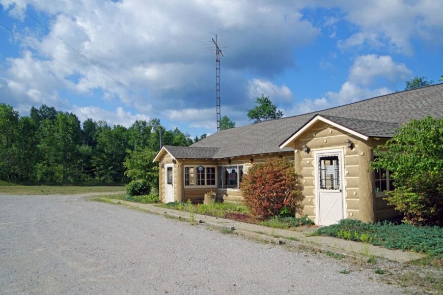
Lewiston is wrapped in water and pines, a resort-style village that still feels deeply secluded. Longtime cottages line the shores of East Twin Lake, while nearby roads wander through jack pine barrens that hide sandy-bottom streams.
Summer brings anglers, paddlers, and berry-pickers; autumn draws hunters and leaf-watchers to the surrounding hills. The year-round population is small, with tourism and seasonal services filling out the economy.
Despite being a vacation spot, it never loses its easy, woodsy rhythm. At night, the silence deepens to the crackle of campfires and the distant call of loons.
Where is Lewiston?
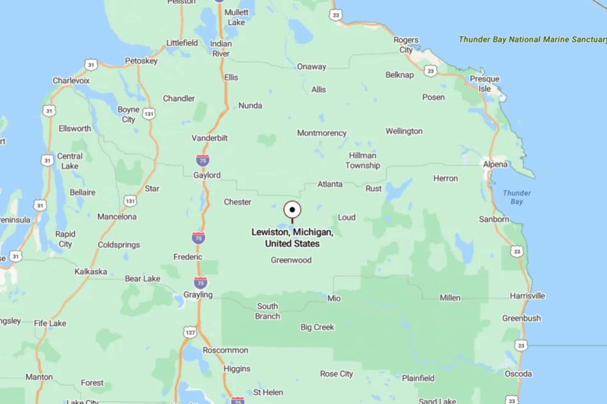
Located in central Montmorency County, Lewiston is about 30 miles southeast of Gaylord. The town is accessed via M-32 and County Road 489, winding past forests and lakes.
It’s well off any major highway, which helps preserve its quiet setting. The arrival feels like slipping into a pocket of woods carved away from the rush of the world.
23. Atlanta – Elk Capital with Starry Skies
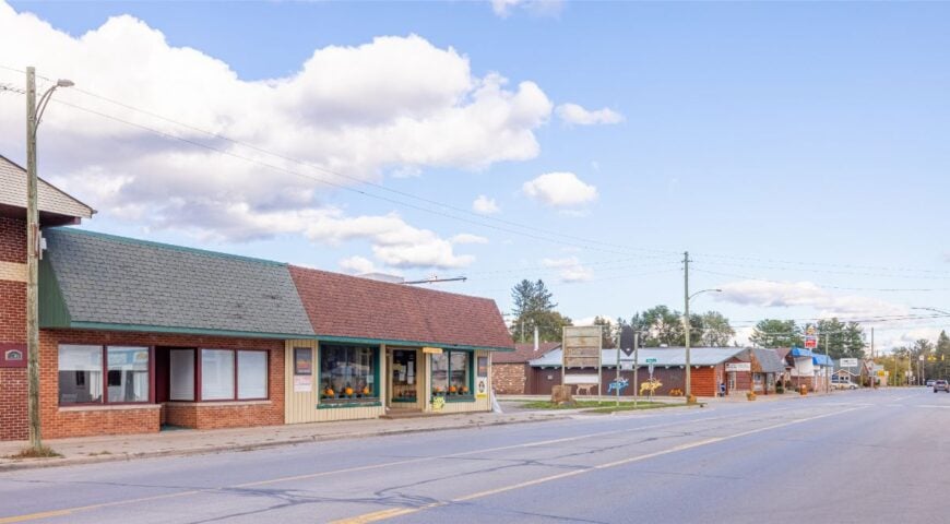
Atlanta calls itself the “Elk Capital of Michigan,” and the title fits: herds often graze the fields just outside of town at dawn. Despite that claim to fame, it remains a quiet crossroads community with only a handful of shops, diners, and a feed store.
Outdoor life rules here—elk viewing, hiking the Thunder Bay River State Forest, or fishing secluded streams that cut through cedar swamps. Local income comes from logging, small-scale farming, and seasonal tourism, but the economy has never outpaced the land.
Nights are famously dark, with skies so clear the Milky Way feels within reach. It’s a town where nature’s grandeur is the main stage, and people live gently around its edges.
Where is Atlanta?
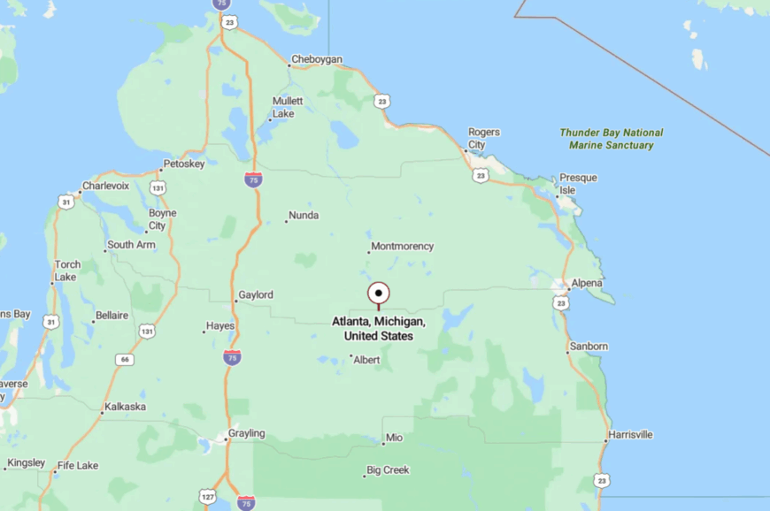
Atlanta lies in Montmorency County, about 45 miles southwest of Alpena and 40 miles north of Grayling. It’s reached by two-lane state highways—M-33 and M-32—that keep interstate traffic far away.
Dense forest buffers it on nearly every side, ensuring peace and quiet. By the time you roll into town, the only glow on the horizon comes from the stars.
22. Comins – Pines, Cabins, and the Sound of Silence
Comins is more of a cluster than a town, but its hush is its charm. A scattering of cabins, farms, and a single café form the center, surrounded by endless jack pines and narrow rivers.
Anglers drift the Big Creek, hunters roam the nearby state land, and birdwatchers listen for the flute-like notes of hermit thrushes. Logging once built the area, but now it’s a quiet pocket where many make their living through small trades, farming, or seasonal guiding.
Evenings bring coyotes howling across fields and an enveloping silence broken only by wind in the trees. Comins is proof that seclusion doesn’t need fanfare to feel complete.
Where is Comins?
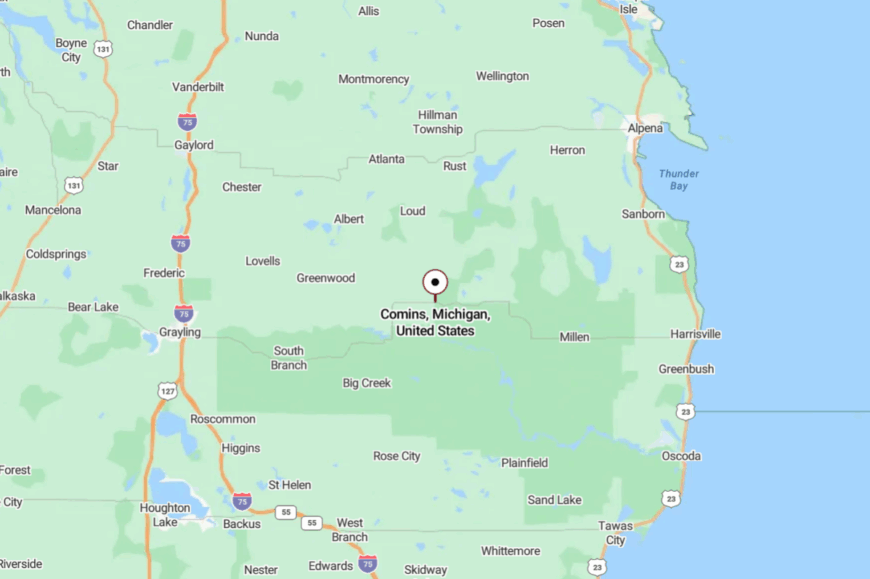
Comins is located in Oscoda County along M-33, about 15 miles north of Mio. It’s well off major thoroughfares, hidden among the forests of northeast Michigan’s interior.
The drive in is lined with rolling farmland and pine flats. Once there, the quiet settles in so naturally that it feels like it was waiting for you.
21. Lincoln – A Sleepy Village Near the Huron Shore
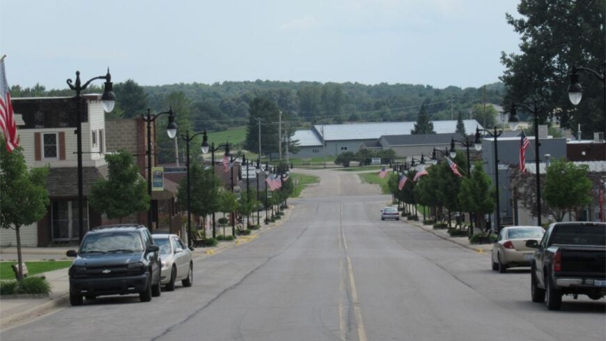
Lincoln rests between lakes and farmland, a small village where time seems to move at half speed. Homes cluster around Lincoln Lake, while a few mom-and-pop shops serve the modest population.
Locals fish at dawn, gather at the village square for festivals, or take short drives to the quiet beaches of Lake Huron. The town’s economy leans on farming and local services, but it carries the feel of a place forgotten by hurry.
With minimal traffic and no chain stores, it’s the sort of village where even footsteps seem polite. Nights are dark and hushed, with only frogs and crickets marking the hours.
Where is Lincoln?
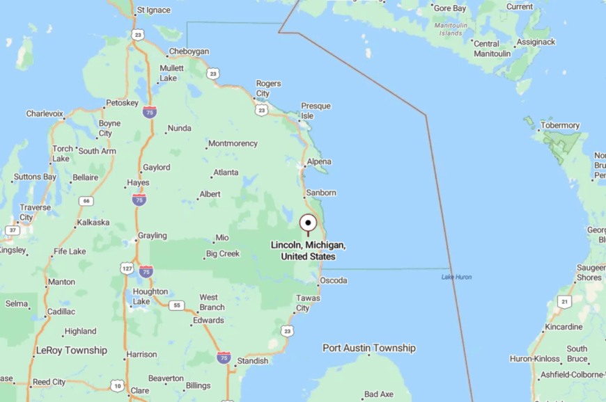
Lincoln lies in Alcona County, about 11 miles inland from Lake Huron and 25 miles south of Alpena. It’s reached by M-72 and M-65, two-lane highways bordered by forest and farmland.
The town sits just far enough from the shoreline to avoid tourist bustle. Once you arrive, the landscape feels tucked in and set apart from the modern world.
20. Hubbard Lake – Bays, Bluffs, and Timeless Views
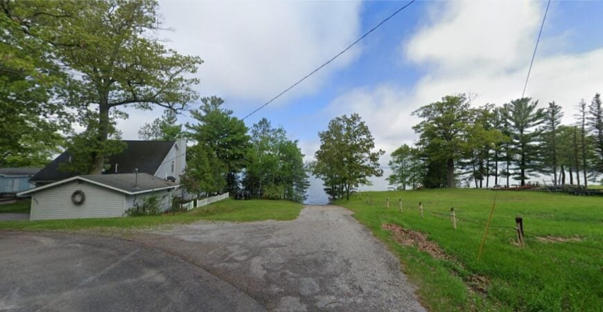
Hubbard Lake itself feels like a hidden inland sea, and the town at its heart is just as secluded. Fewer than 1,000 residents live around its shores, many in homes tucked into maple ridges or pine bluffs.
Days revolve around the water—fishing, kayaking, or simply watching light shift across its broad surface. The local economy ties into cottages, rentals, and caretaking, but life is paced by the lake rather than commerce.
Seasonal cottages add to the rhythm, swelling with life in summer before returning to stillness in fall. Even in July, the atmosphere stays hushed, broken only by loon calls and the soft lap of waves.
Where is Hubbard Lake?
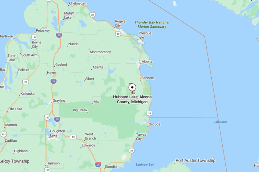
Hubbard Lake straddles southern Alpena County and northern Alcona County, about 20 miles south of Alpena. The community is accessed by county roads branching off M-72, narrowing as they near the lake.
Forested hills and winding shorelines add a natural buffer from the outside world. Once you arrive, the lake’s vast horizon makes everything else feel far away.
19. Black River – Forgotten Fishing Village on Lake Huron
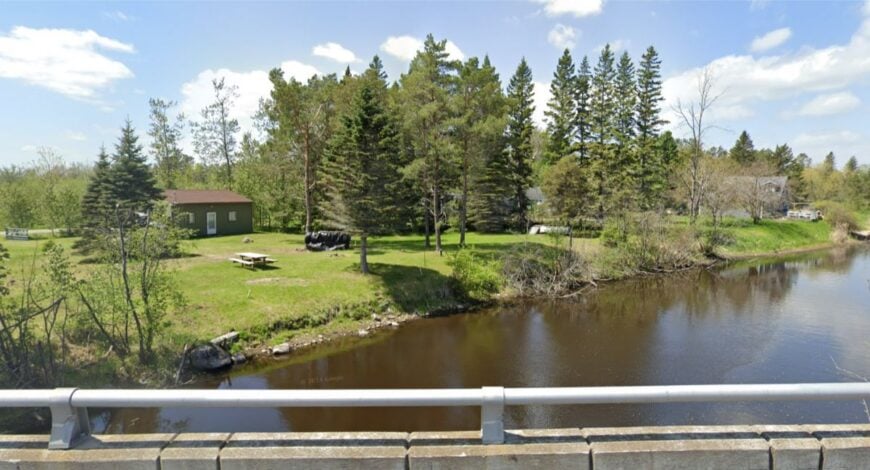
Black River is a historic harbor hamlet that feels barely touched by time. The old stone breakwall, a handful of fishing boats, and weathered cottages tell the story of a place built for the lake.
Today, locals fish Lake Huron, walk the sandy beach at sunrise, or explore the lighthouse just down the coast. The village itself offers only a tavern, a small marina, and quiet roads shaded by maples.
There’s little in the way of commercial bustle—most people rely on farming or nearby towns for work. What remains is a place shaped by water and quiet endurance. The sound of gulls replaces traffic, and stars shine freely above the dark shoreline.
Where is Black River?
Black River is in Alcona County, about 15 miles north of Harrisville and 20 miles south of Alpena along US-23. The harbor road veers off the highway, taking you toward the lake through patches of cedar swamp.
Its location between bigger towns keeps it hushed and overlooked. By the time you stand at the water’s edge, the rest of the world feels far behind you.
18. Posen – Polish Heritage Amid Wide Farmland
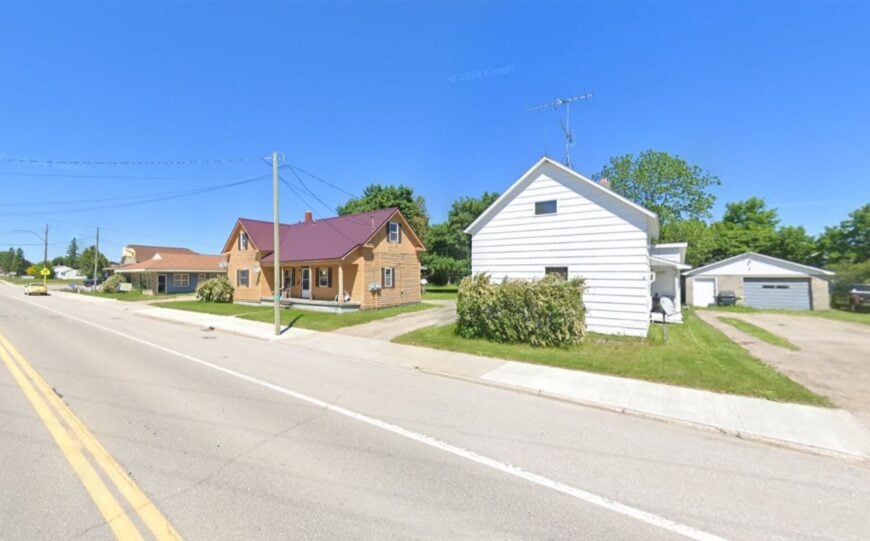
Posen is known for its Polish roots and quiet farmlands that stretch across the horizon. With only a few hundred residents, it feels more like an extended neighborhood than a town.
Each fall, the Posen Potato Festival brings together locals and visitors for parades, music, and heritage foods. The rest of the year, life is slow and agricultural—dairy farms, potato fields, and feed stores set the pace. A handful of churches and old barns mark the skyline, while backroads unspool into unbroken countryside.
Evenings here are marked by cricket songs and the far-off hum of tractors heading home. Posen’s quiet endurance gives it a warmth that feels timeless.
Where is Posen?
Posen lies in Presque Isle County, about 15 miles northwest of Alpena along M-65. It’s tucked into rolling farmland between Rogers City and Alpena.
Reaching it means leaving the faster highways for two-lane rural roads. Once there, the openness of the fields makes the quiet feel even larger.
17. Metz – Ghosts of Fire and Fields of Quiet
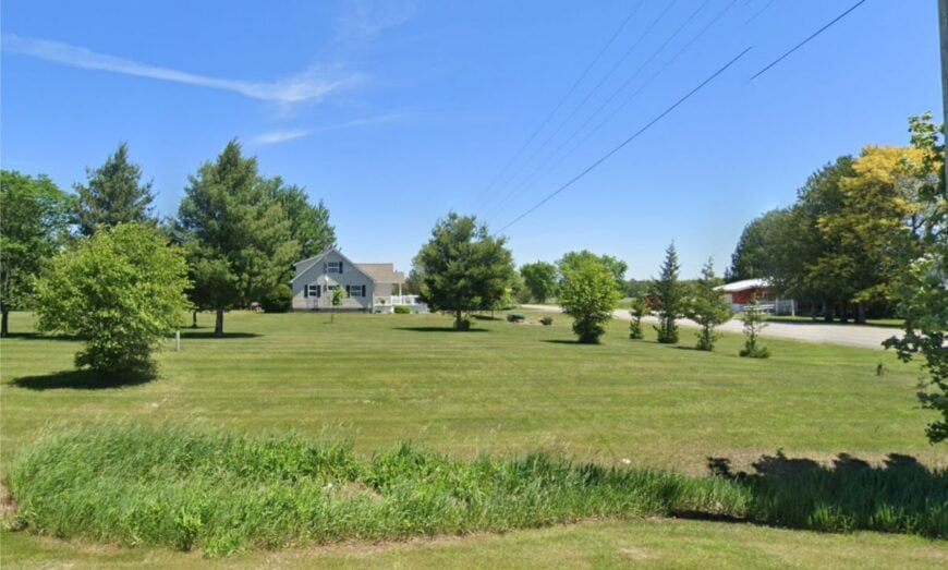
Metz is a place where history lingers in the silence. Nearly destroyed in the great forest fires of 1908, the town rebuilt modestly, leaving behind monuments and a small museum that whispers of resilience.
Today, it’s a scattering of farmhouses, a church, and open fields hemmed by woodlots. The landscape is wide and uncluttered, with few signs of modern development.
Locals farm the land, hunt the forests, and honor the past each October at the Fire Trail memorial event. Even on sunny days, there’s a stillness to Metz that feels half-forgotten. It’s a place where quiet is both heritage and present tense.
Where is Metz?
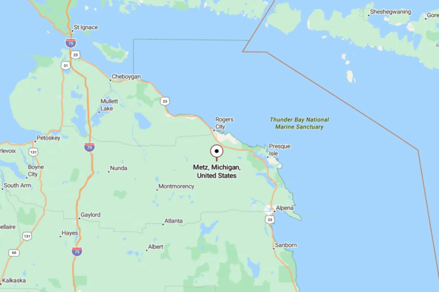
Metz sits in Presque Isle County, about 20 miles northwest of Alpena. It’s reached via County Road 441, a two-lane that runs through farmland and patches of second-growth forest.
The nearest large town is Rogers City, 15 miles to the northeast. Metz’s position off main highways leaves it feeling tucked away, where the land and its history do most of the talking.
16. Onaway – Steel Town Turned Forest Haven
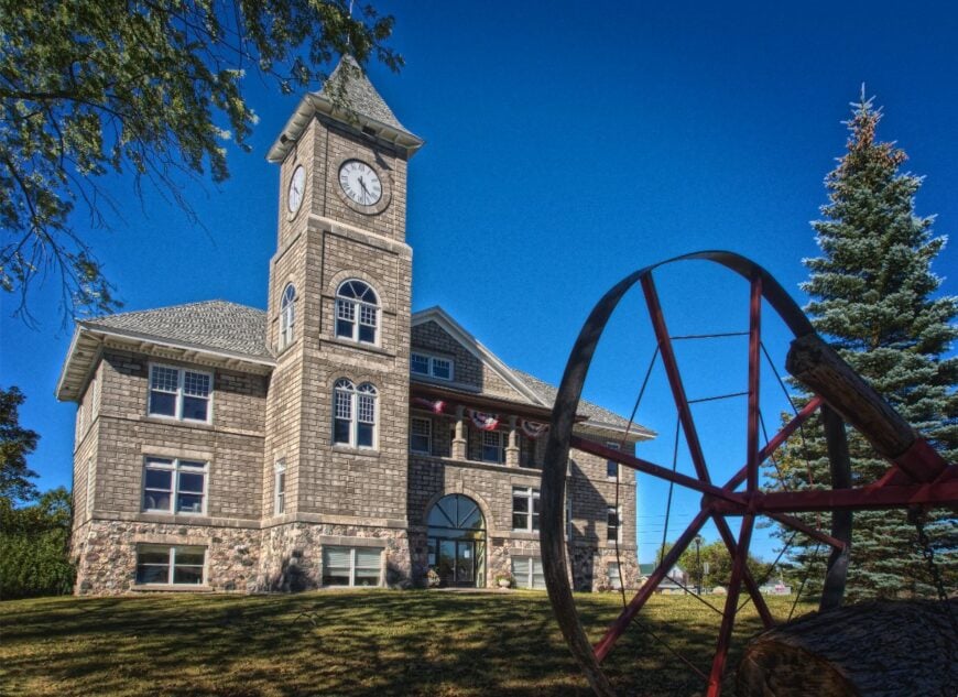
Onaway was once a booming steel wheel town, but today it’s a quiet community framed by forest and lakes. Remnants of its industrial past mix with tree-lined streets and small shops.
Locals fish Black Lake, wander the Ocqueoc Falls trails, or explore the annual arts and crafts festival that livens Main Street. The economy now leans on tourism, retirees, and small-scale manufacturing, but the overall feel is calm and neighborly.
Red pines whisper at the town’s edges, and wildlife often roams close to porches. What’s left is a place that traded industry for intimacy. Onaway’s charm is that it remembers its past while living quietly in its present.
Where is Onaway?
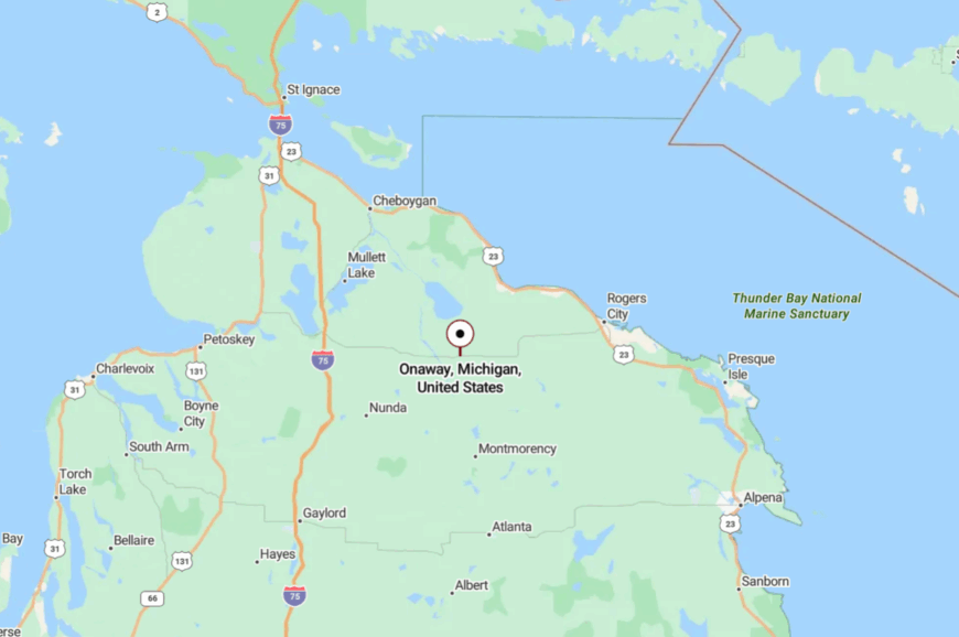
Onaway is located in Presque Isle County, about 12 miles east of I-75 and 20 miles southwest of Rogers City. The town is reached by M-68, a two-lane highway that winds through rolling hills.
Forest and farmland wrap it on all sides, keeping it shielded from heavy traffic. Arriving here feels like stepping out of one era and into another.
15. Ossineke – Limestone Cliffs and Lake Huron Breezes
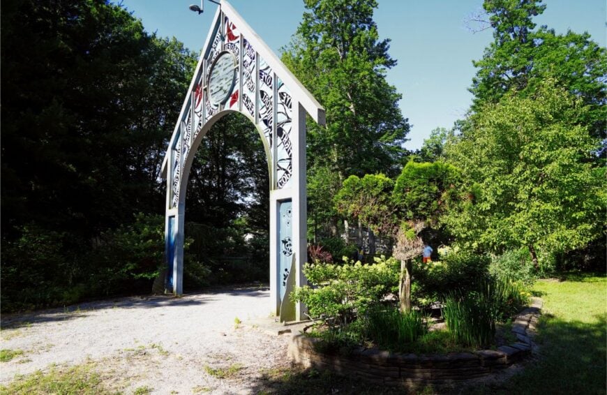
Ossineke is a small lakeshore village where limestone cliffs rise above Lake Huron’s breezy shoreline. The community feels tucked away despite lying on US-23, softened by the surrounding cedar swamps and nearby state forest.
Visitors stop at the quirky Dinosaur Gardens, picnic on quiet beaches, or explore Negwegon State Park just down the road. Farming and small businesses support the town, but tourism remains light compared to neighboring Alpena.
Life here hums at a modest, porch-swing pace. Evenings are ruled by the sound of waves and wind through cedar boughs. Ossineke feels like the shoreline slowed down just for itself.
Where is Ossineke?
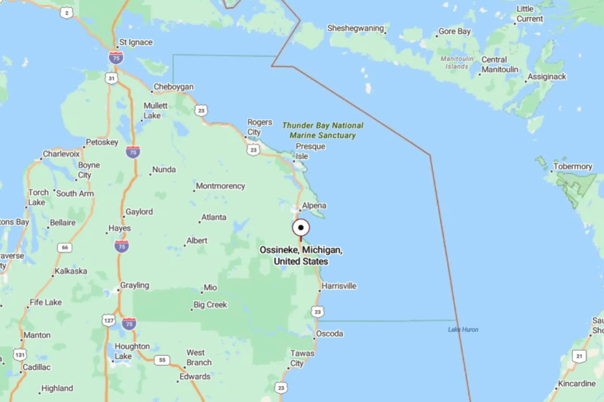
Ossineke sits in southern Alpena County, about 11 miles south of Alpena on US-23. It’s nestled between Lake Huron’s shore and inland hardwood ridges.
Access is easy, but its quiet beaches and forest buffers keep it hushed. By the time you find yourself walking the bluffs, it feels far removed from city noise.
14. Alpena Township Backroads – Hidden Homesteads Beyond the City Glow
Just outside Alpena, the township backroads offer a surprising pocket of seclusion. Scattered farmsteads, maple groves, and tucked-away cabins line gravel lanes where traffic is rare.
Residents tend small herds, run roadside stands, or commute into Alpena while keeping their homes wrapped in country quiet. Visitors discover hidden fishing spots on the Thunder Bay River or hike through patches of state forest.
Despite being minutes from town, the vibe is rural and restful, with night skies dark enough to reveal a blanket of stars. The hum of the city fades completely just a few miles out. It’s proof that seclusion can hide right next door.
Where is Alpena Township Backroads?
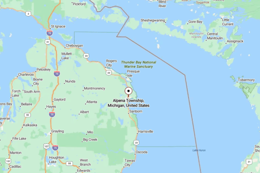
These quiet homesteads lie west and north of Alpena, stretching along country roads beyond US-23. You reach them by turning off the main highway onto gravel and tree-lined lanes.
Though close to town, fields and forest create an immediate sense of removal. It’s the kind of countryside where the city glow never quite reaches.
13. Killmaster – Rustic Cabins in the Huron Forest
Killmaster is little more than a name on a map, but its rustic cabins and forest clearings make it feel timeless. Surrounded by the Huron National Forest, it’s a place of sandy soil, tall pines, and the steady sound of wind moving through needles.
Visitors camp, hunt deer in season, or fish the nearby Au Sable tributaries. Work is scarce—most residents rely on small trades or seasonal guiding—but the quiet is its real wealth.
Gravel roads fade quickly into trails, and cell signals vanish into the trees. The nights are black and endless, broken only by owl calls and the crackle of campfires. Killmaster is seclusion in its purest form.
Where is Killmaster?
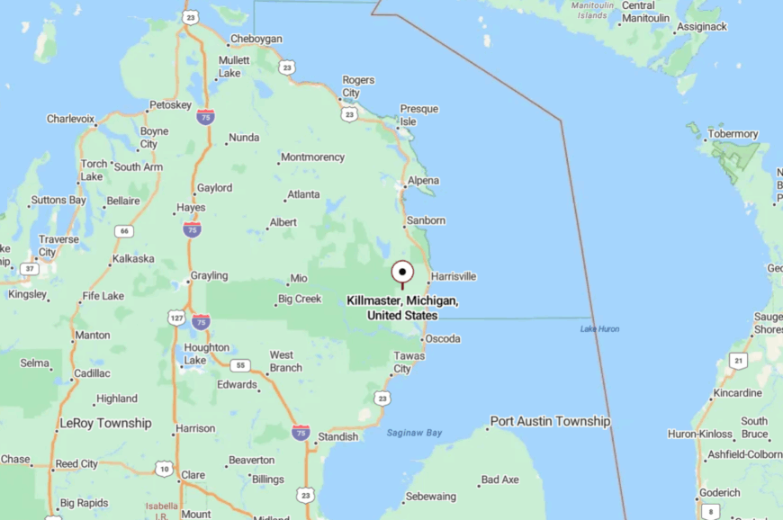
Killmaster sits in western Alcona County, about 15 miles west of Harrisville. It’s reached by F-30 and gravel forest roads that tunnel through miles of pine.
The nearest town is a half-hour away, leaving it naturally shielded from bustle. The drive in feels like a step back into an earlier, quieter Michigan.
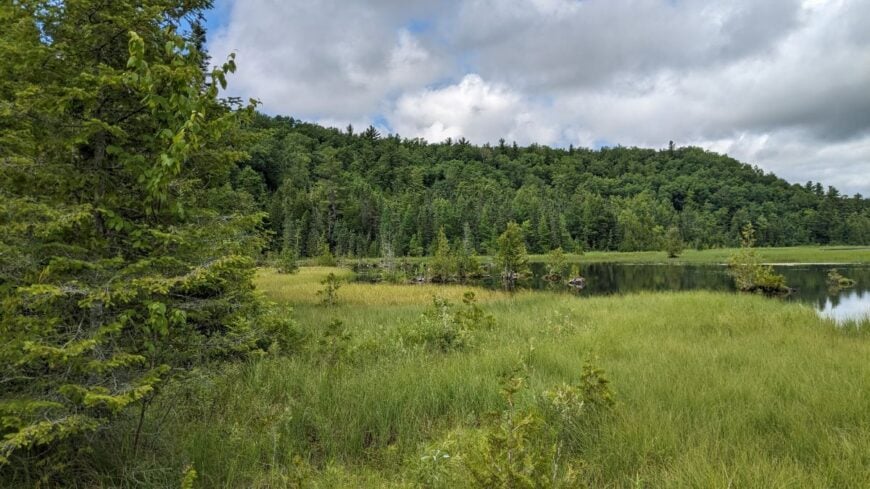
12. McKinley – Forgotten River Hamlet in the Huron Forest
McKinley is the kind of place you might miss if you blink, a scattering of cabins and cottages tucked along the Au Sable River in the middle of the Huron National Forest. With only a handful of year-round residents, it feels more like an outpost than a town, where trout fishermen and paddlers outnumber cars.
Life here hums softly—porch swings creak, woodstoves crackle, and the river provides its own steady rhythm. Visitors come for canoe trips down the Au Sable, deer hunting in the surrounding forest, or quiet weekends at rustic rentals.
There are no shops or cafés, just the essentials of river life and the comfort of deep woods. McKinley’s remoteness makes it feel timeless, as though the modern world decided to pass it by. It’s a refuge for anyone who longs to hear only water, wind, and their own thoughts.
Where is McKinley?
McKinley lies in western Oscoda County, about 15 miles west of Mio and deep within the Huron National Forest. The nearest highways—M-72 and M-33—run miles away, leaving only winding forest roads to reach the hamlet.
Access often comes by McKinley Road, a ribbon of pavement that fades into gravel as the trees close in. By the time you arrive, the river and pines have already pushed the outside world far behind.
11. Mio – Riverbend Village Surrounded by Pines
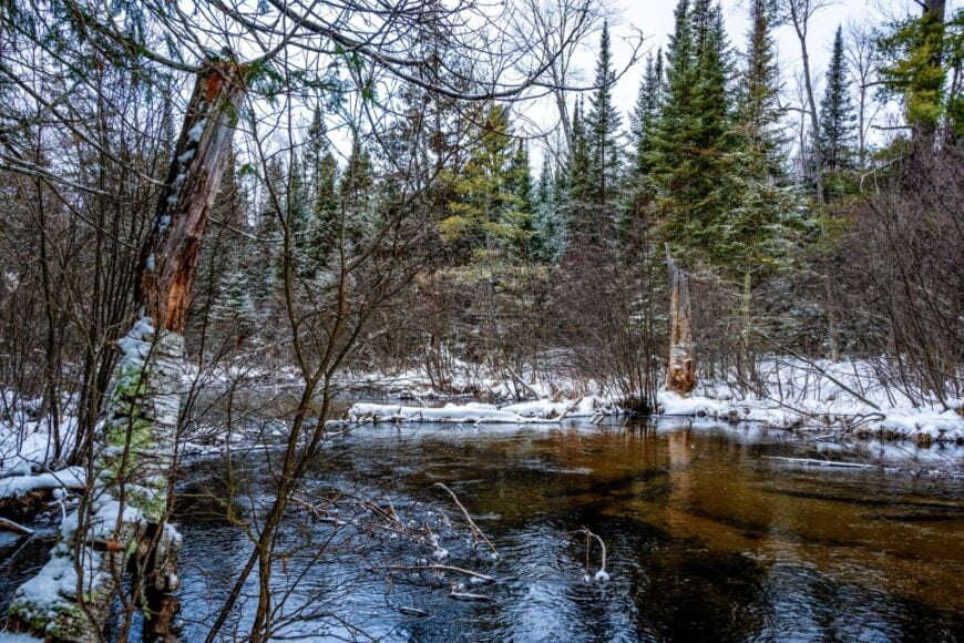
Mio feels like a quiet bend in the map, wrapped by the Au Sable River and the rolling ridges of the Huron National Forest. With fewer than 2,000 residents, it’s small enough to feel personal, yet distant enough from major cities to remain untouched by sprawl.
Anglers drift the Au Sable’s legendary currents, hikers explore the Highbanks Trail with its sweeping overlooks, and birders gather for a glimpse of the endangered Kirtland’s warbler in the sandy jack pine plains nearby. Local life is anchored by a modest main street—cafés, outfitters, and a few small shops that cater to both residents and seasonal wanderers.
Logging and tourism sustain much of the economy, but the forest always has the louder voice. Nights here are deep and starry, with the river whispering through the dark. Mio is the kind of place where the woods set the pace, and you’re glad to follow.
Where is Mio?
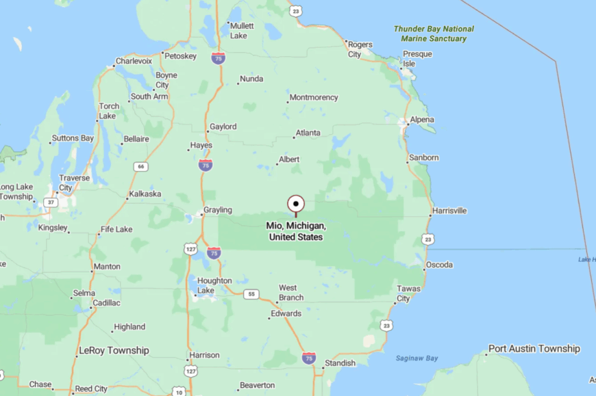
Mio sits in central Oscoda County, about 30 miles southeast of Grayling and far from the pull of any interstate. The town is reached by M-33 or M-72, two-lane highways that cut through pine forests and long stretches of quiet countryside.
Roads narrow into the river valley as you approach, making the village feel like a tucked-away basin in the woods. By the time you arrive, the outside world feels pleasantly distant, replaced by river air and tall pines.
10. Fairview – Amish Countryside Hidden in the Hardwood Hills
Fairview’s year-round population hovers just below 400, many of them members of the area’s long-established Amish community.
Visitors spend days browsing handcrafted rockers at Miller’s Wood Shop, picking blueberries along Reber Road, or catching the fall color explosion on nearby Forest Highway 23. Small-scale dairy farms and woodworking sheds form the economic backbone, with maple-syrup operations adding sweet seasonal income each spring.
Even the post office closes by mid-afternoon, and the steady clip-clop of horse-drawn buggies replaces morning rush hour. Encircled by the Huron National Forest and a maze of gravel ridges, the hamlet sits miles from any chain restaurant or stoplight, leaving the Milky Way unspoiled overhead.
Cell-service dead zones are common, a quirk locals view as an extra layer of peace.
Where is Fairview?
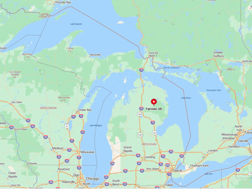
Fairview rests in central Oscoda County on M-33, roughly 25 miles northeast of West Branch and 45 miles south of Alpena. Thick maple and beech stands buffer every road, adding both windbreak and privacy.
M-33 is the lone paved artery; once the turn onto Reber or Weaver Road is made, fresh gravel and deer tracks guide the way. Most travelers reach the village via I-75 to M-33, though many prefer the slower, scenic Forest Highway 23 from the Au Sable River valley.
9. Glennie – The Crossroads Hamlet on the Edge of the Au Sable
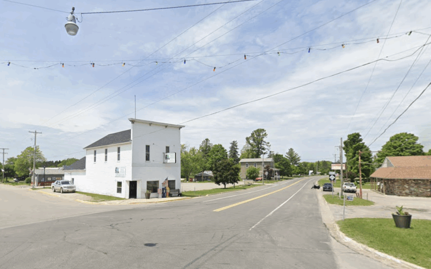
Glennie counts roughly 250 residents, but the number feels smaller after sundown when the last porch light clicks off. Anglers drift the nearby Au Sable River for steelhead, while paddlers launch at Five Channels Dam for day-long floats through whispering pines.
A pair of taverns, one bait shop, and seasonal jobs tied to hunting camps provide modest livelihoods. With no grocery store closer than Oscoda—30 miles east—the settlement sidesteps tourist traffic and late-night neon.
Gravel roads vanish into state forest within minutes, muffling highway noise and cell signals alike. Silence returns so completely after dark that barred owls often serve as the only town criers.
Where is Glennie?
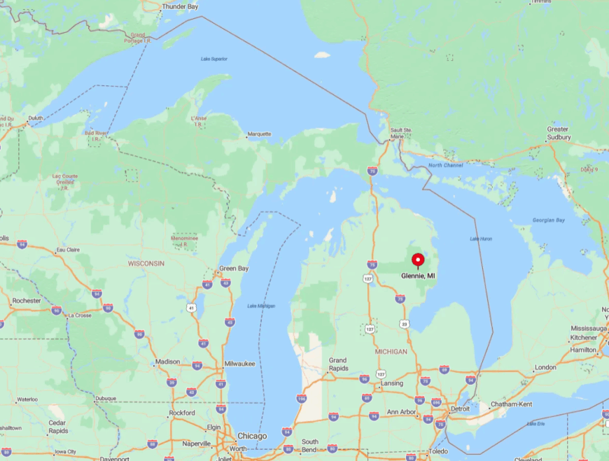
Glennie lies at the junction of M-65 and Bamfield Road in western Alcona County, a two-lane hour west of Lake Huron. Unbroken pine barrens run for miles in every direction, explaining the blank spots on many GPS maps.
The simplest access is north or south on M-65, though seasoned travelers use Vaughn Trail—an old logging route—to slip in from the Au Sable Scenic Byway. During heavy snow, locals recommend four-wheel drive; the county plow passes once at dawn and rarely twice.
8. Curran – Tiny Trout Town Tucked Along the Rifle River
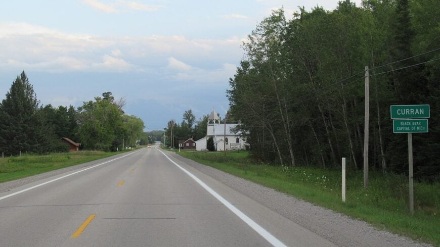
Curran’s census tally sits near 330, a number that triples only during the August Black Bear Festival. Fly fishers stalk brook trout in the nearby Rifle River, and hikers roam 3,000 acres of state forest on the Beaver Lake Pathway.
Timber once ruled; today small sawmills, bait shops, and vacation-rental caretakers handle most paychecks. Historic lumber shanties line the side streets, some now converted to rustic rentals with wood-burning stoves.
Housing density stays below 100 residents per square mile thanks to wide parcels and conservation easements protecting river corridors. Nights fall quietly, broken only by the splash of beavers upstream and an occasional passing freight train far to the east.
Where is Curran?
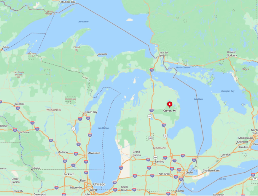
Curran occupies the far western edge of Alcona County on M-72, about 40 minutes east of Grayling and a full hour from Alpena. State forest envelopes the town like a horseshoe, with the Rifle River Recreation Area forming the southern boundary.
Travelers rarely stumble upon Curran by accident; M-72 is the single paved approach, and the nearest interstate is I-75—35 winding miles away. That geographic insulation keeps the river pristine and traffic counts low even at peak foliage season.
7. Hawks – Farming Fields Meet Endless Cedar Swamps
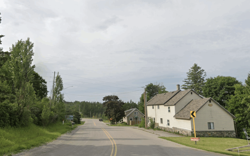
Hawks records an estimated 220 permanent residents spread across hayfields, cedar bogs, and century-old farmsteads. Birders gather at nearby Bonsall Pond every May for warbler migrations, while autumn brings grouse hunters to the Thunder Bay River State Forest just west of town.
Dairy barns, beef cattle, and row-crop acreage support local incomes, with a lone grain elevator marking the skyline. Wildlife outnumbers cars, evidenced by sandhill cranes striding through stubble fields at dawn.
The nearest true supermarket sits 25 miles away in Alpena, underscoring the settlement’s self-reliance. After sunset, dark horizons are interrupted only by the slow blink of a distant silo beacon.
Where is Hawks?
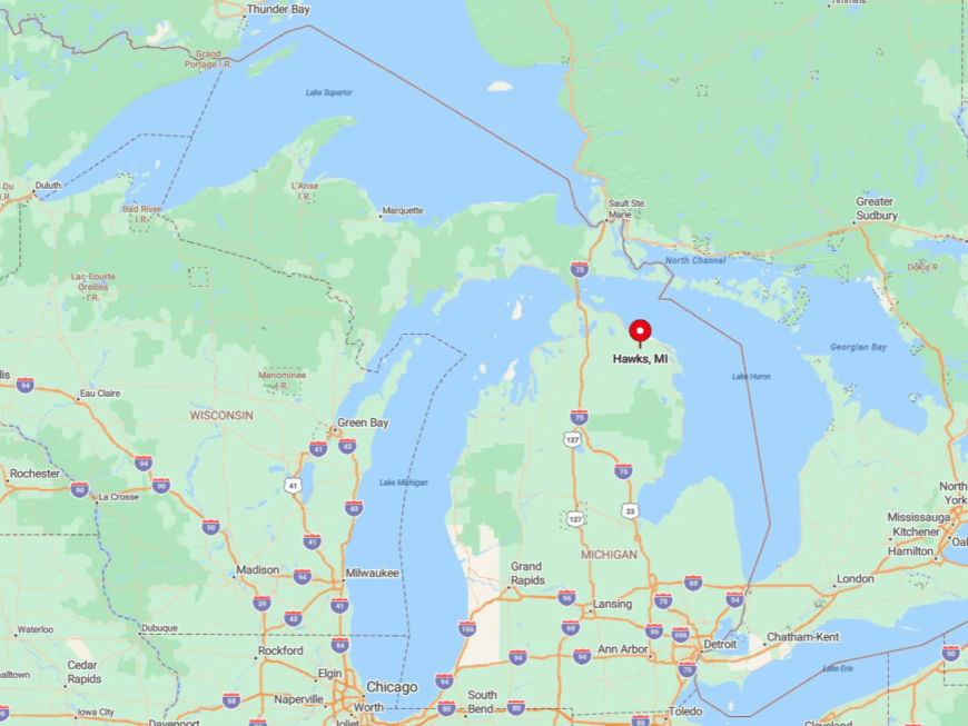
This Presque Isle County outpost straddles County Road 451, roughly halfway between Rogers City and Hillman. Cedar swamps form natural walls on two sides, while farmland stretches unobstructed toward Lake Huron.
County Road 451 is well maintained, yet winter whiteouts can turn the last ten miles into a tunnel of blowing snow. Visitors often detour east on Leer Road for a glimpse of the tiny St. Dominic’s Catholic Church, a stone chapel locals affectionately call the “Church in the Corn.”
6. Mikado – White-Pine Retreat Far From Tourist Coasts
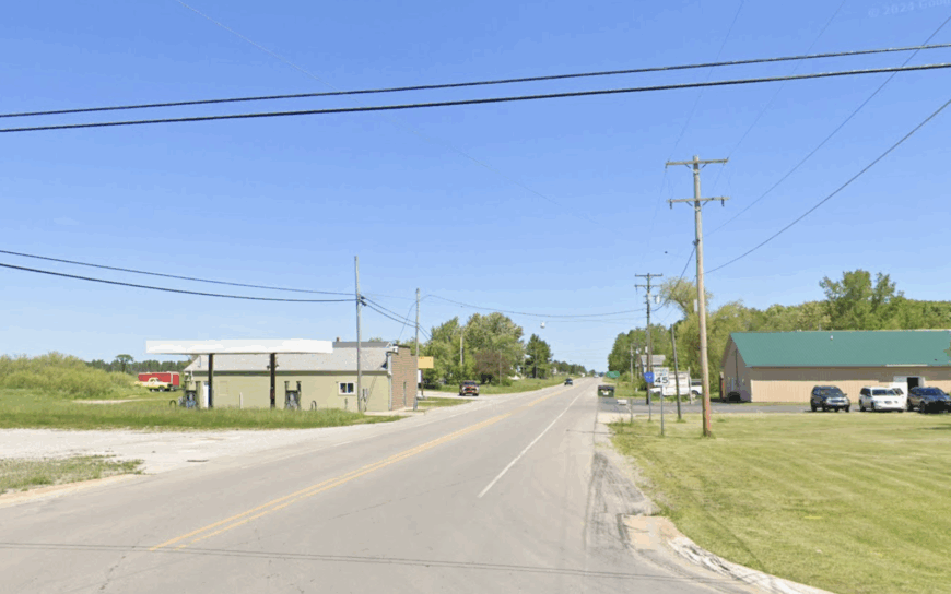
Mikado’s population floats around 300, a figure hinted at by the lone set of gas pumps at the township hall. Days here revolve around trail riding in the Huron-Manistee National Forest, foraging wild mushrooms, or ice-fishing on inland lakes such as Vaughn and Pine.
Logging contracts, seasonal guiding, and a scattering of home-based trades keep bills paid. Chain stores are absent; the nearest fast-food fries are a half-hour east in Oscoda.
Forest roads spiderweb outward, and with no streetlights to give direction, night skies flood with stars clear enough to reveal the faint green smear of aurora on lucky winter evenings. Coyotes provide the soundtrack, yipping from the ridges like distant campfire revelers.
Where is Mikado?
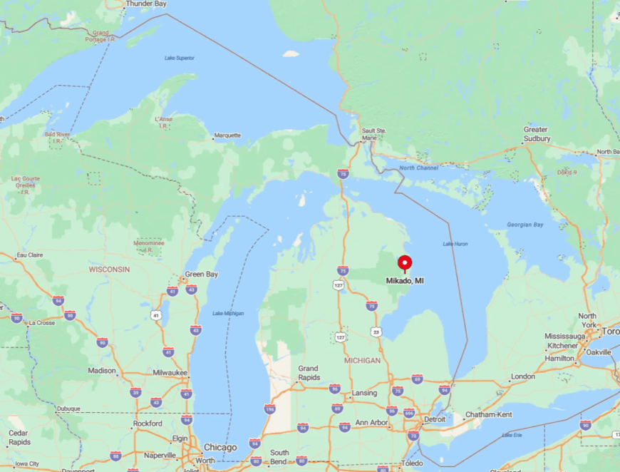
Mikado sits ten miles south of M-72 in southern Alcona County, reachable by Mikado-McKinley Road or the aptly named F-30—a paved ribbon through towering pines. The settlement’s distance from both US-23 and I-75 leaves it pocketed between two quiet corridors.
Travelers often follow the Au Sable River Scenic Byway to F-30, then venture west into deeper forest until cell bars disappear. Winter visitors should check county plow schedules; drifting snow can narrow roads to single-lane tunnels beneath the white pines.
5. Spruce – Quiet Ridges Above Long Lake’s Glassy Bays
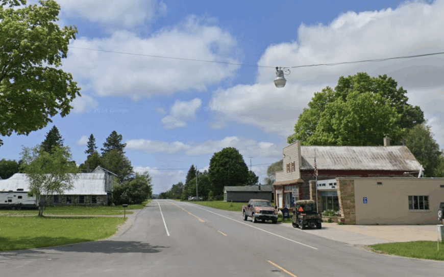
Spruce claims roughly 250 full-time residents, most living on one-plus-acre wooded parcels hidden behind glacial ridgelines. Locals fish Long Lake for walleye at dawn, hike the Devil’s Lake pathway in the afternoon, and finish with a nightcap at the Spruce Bar—a roadhouse unchanged since 1948.
Cottage maintenance, small-scale construction, and part-time farming form the primary livelihoods. Supplies require a 25-minute run to Alpena, a trip that deters casual traffic and keeps boat wakes low even in July.
Shielded coves and hardwood hills eclipse light pollution, giving stargazers mirror-still reflections of Orion on the lake surface. Even July Fourth fireworks feel muted, absorbed by treeline instead of echoing off concrete.
Where is Spruce?
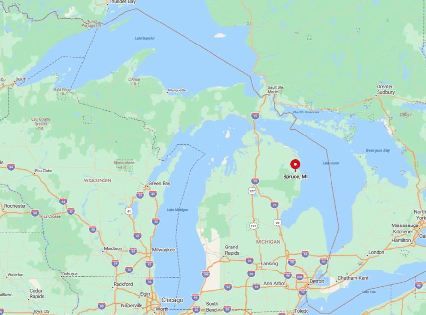
Spruce straddles the Alpena-Alcona county line on Spruce Road, three miles west of US-23 and Lake Huron. The settlement sits higher than the surrounding valleys, offering unbroken sunset views across Long Lake.
Visitors exit US-23 at Goddard Road, then weave through rolling farmland until cell-service strength flickers. Because county crews prioritize lakefront highways, the ridgeline’s gravel lanes often retain a charming dusting of snow long after storms pass.
4. Lachine – Rail-Trail Village Wrapped in Farmsteads
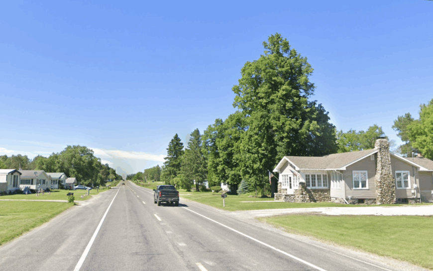
Lachine lists about 350 residents along its single-mile Main Street, anchored by a classic four-way stop and an aging grain elevator. Cyclists roll in on the Alpena-to-Hillman rail trail to grab homemade pie at Rosa’s Before hitting the next leg west.
Corn, soybeans, and hay blanket surrounding farms, while part-time rail-trail tourism props up the diner and a small engine-repair shop. Nearly half the township’s acreage remains undeveloped, ensuring broad intervals of silence between porch lights.
Because US-23 traffic diverts toward Alpena’s shoreline, Lachine avoids the seasonal swarm headed for Lake Huron beaches. Dusk brings a hush so complete that an eastbound freight five miles away sounds like it’s clipping the back fence.
Where is Lachine?
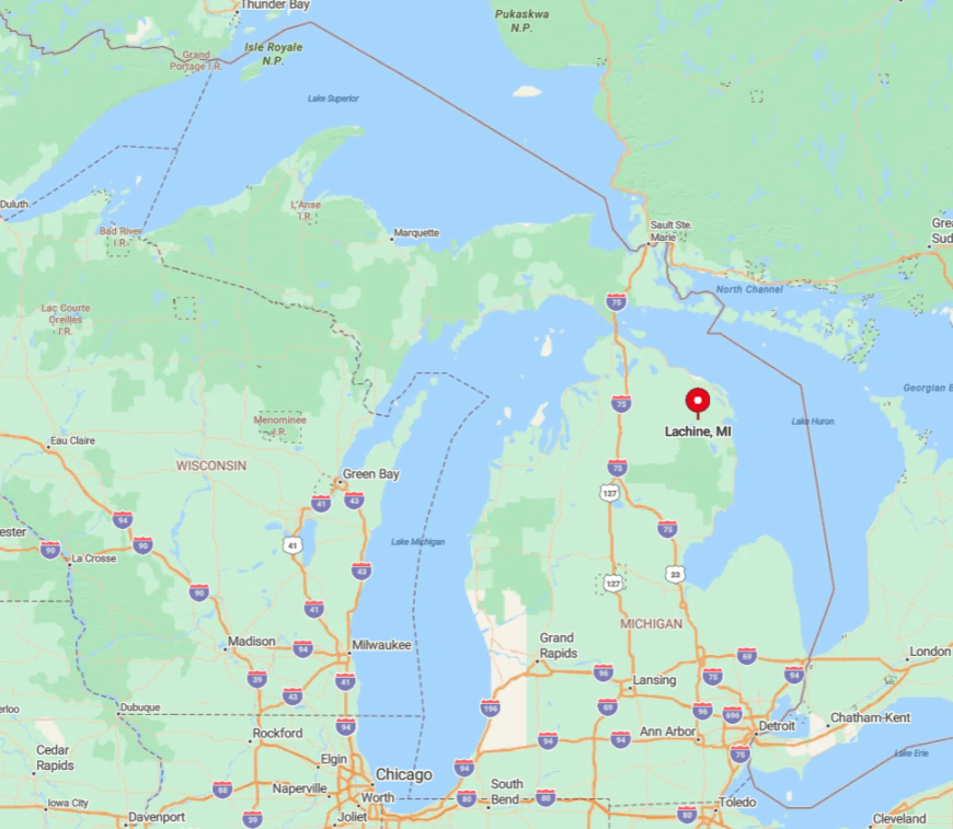
The village sits on M-65 in western Alpena County, 15 miles from Alpena and 10 miles from Hillman. Wooded windbreaks and tall cornfields reduce visibility from the highway, making Lachine easy to miss without its landmark grain elevator.
Access is simplest via M-65, although cyclists prefer the level rail trail that parallels the Thunder Bay River. During harvest, slow-moving combines often occupy both lanes of M-65, so patience is not just polite—it’s required.
3. Barton City – Bass Lake Hideaway in the “Jewel of the Huron Forest”
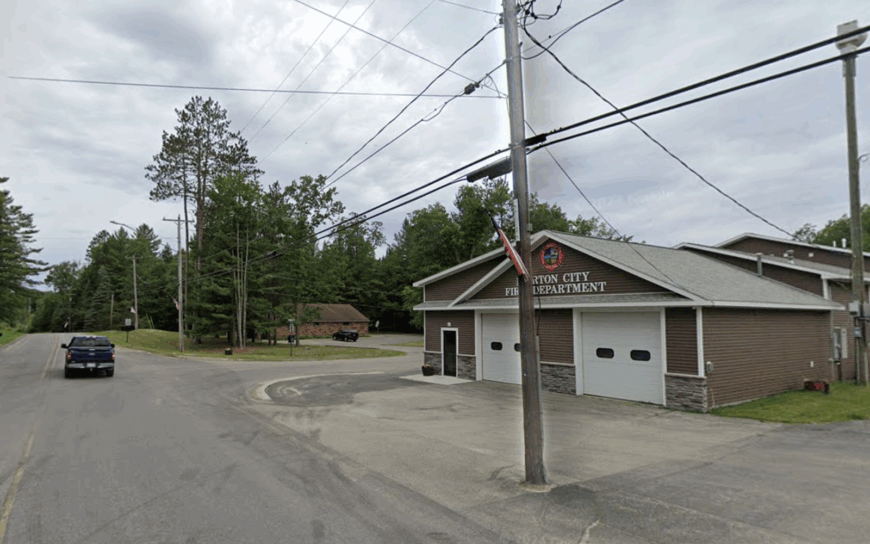
Barton City’s year-round headcount sits near 300, but summer cottages around Jewel Lake swell the figure on holiday weekends. Anglers chase largemouth bass at dawn, while hikers attack the Hoist Lakes Foot Travel Area’s 10,000 acres of loops and overlooks.
The 1920s log cabins ringing Jewel Lake shift from family heirlooms to short-term rentals, forming the backbone of the local economy along with a timeless community store and one tavern. Sand roads are the norm; pavement ends half a mile before the lake, adding a welcome sense of removal.
State forest hugs the shoreline like a protective collar, throttling development and keeping porch-to-porch spacing generous. Clear nights invite stargazing, with Jewel Lake’s still surface doubling every constellation.
Where is Barton City?
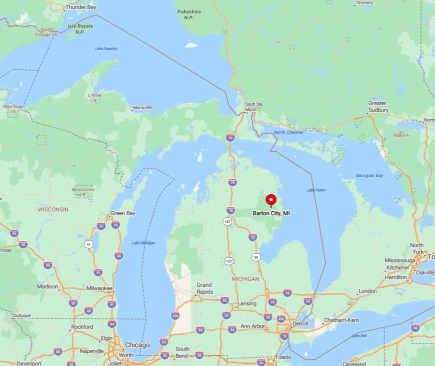
The hamlet hides in central Alcona County along Barton City Road, 17 miles northwest of Oscoda. No state highway cuts through; instead, visitors follow M-72 or F-41 before dropping south on forest roads that narrow from blacktop to sand.
That lack of through-traffic preserves early-morning calm and limits noise to loons echoing across the water. Winter access demands four-wheel drive or patience—deep ruts and unplowed drifts keep casual visitors honest.
2. Herron – Hilltop Homesteads Above the Thunder Bay Valley
Herron hosts just under 200 residents scattered across elevated farms and sugar-maple groves. The hilltops deliver striking sunrise views over the Thunder Bay River floodplain, while rock hounds sift road cuts for Devonian fossils—a local secret older than the Great Lakes themselves.
Income stems from cattle, hay, and a sprinkling of home-based maple syrup shacks that fire up each March. Bordered by ridgelines on three sides and shielded from city glow, Herron reports population densities under 50 per square mile, making weeknight stargazing a near-religious experience.
With Alpena’s amenities 18 miles away, spontaneous pizza isn’t an option, reinforcing advance planning and self-sufficiency. After dark, only barn owls and distant coyotes compete with the hush.
Where is Herron?
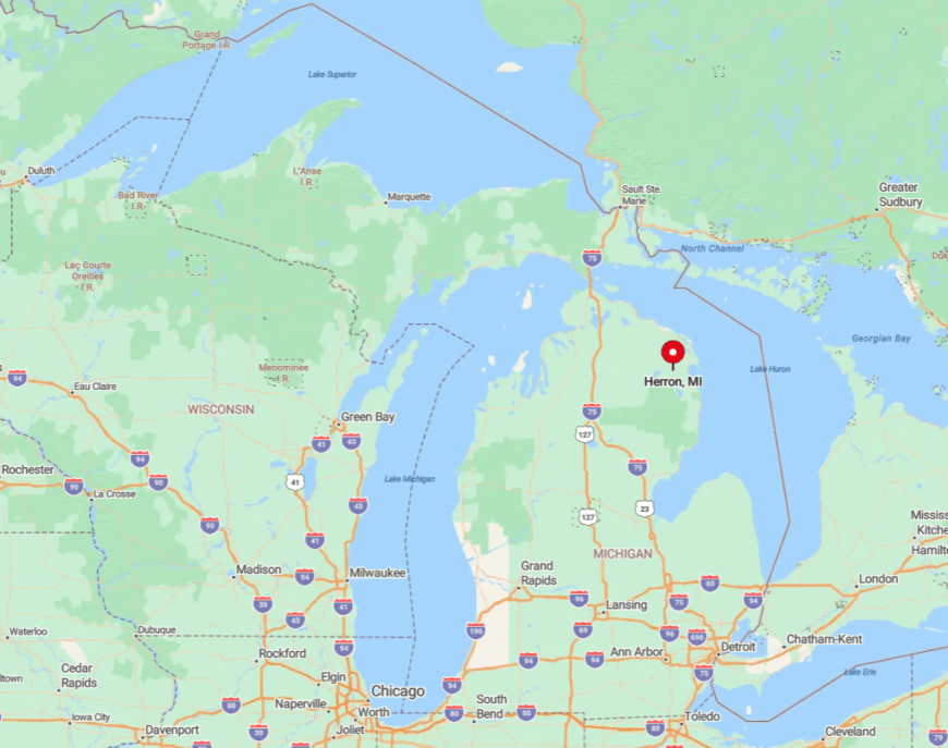
Herron sits along M-32 in western Alpena County, perched 200 feet above the Thunder Bay River valley. The elevated terrain funnels most traffic to flatter routes, leaving M-32 calm outside morning milk runs.
Travelers often exit US-23 at Alpena, then climb west on M-32 until rolling farmland replaces subdivision rooftops. Winter storms can coat the high ground with lake-effect snow unseen on the shore, so locals keep chains handy.
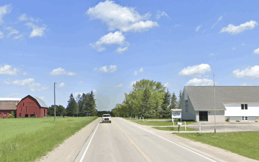
1. Millersburg – Forgotten Railroad Stop with Room to Roam
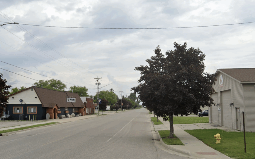
Millersburg records a population of about 210, a figure unchanged since iron rails first reached here in 1897. History buffs explore the abandoned depot and stroll meadow-lined dirt lanes where deer tracks outnumber tire treads.
Farming, small-game hunting product sales, and remote-worker incomes now replace rail commerce, though a vintage grain elevator still stands sentry beside the old right-of-way. Situated 25 miles from both Cheboygan and Rogers City, the village sidesteps coastal tourism entirely.
Nearly every home sits on multiple acres, and Presque Isle County’s sprawling state forestlands hem in further development. When evening falls, whip-poor-wills sing unchallenged by traffic noise or street-lamp glare.
Where is Millersburg?
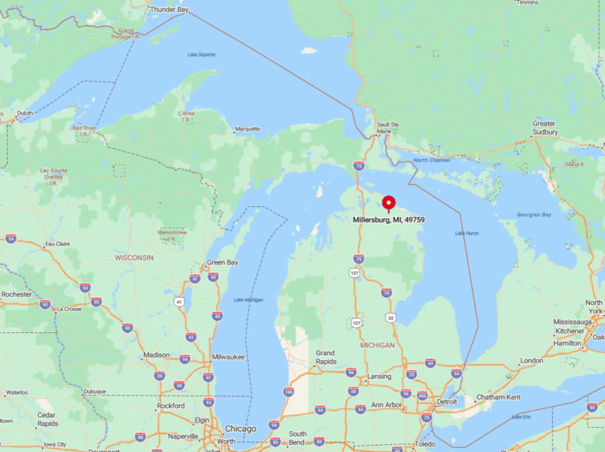
The town rests at the intersection of County Roads 638 and 653 in northwestern Presque Isle County, four miles east of the Black Mountain Recreation Area. No federal highway passes within 15 miles, leaving the closest four-lane options as I-75 to the west or US-23 to the east.
Most visitors navigate via M-68, then turn north onto the county grid until pavement surrenders to dust. That geographic pocketing blunts both lakefront crowds and interstate din, making Millersburg the quietest full-service settlement in all of Northeast Michigan.