Hurricane Erin continued to churn in the North Atlantic well southeast of New England on Friday. Rip currents will continue to plague parts of the U.S. East Coast, Bermuda, and Atlantic Canada into the weekend, as Erin’s massive circulation – including tropical-storm-force winds spanning an area 600-700 miles wide – pushes immense volumes of high surf. Erin had already embarked on its transition into a powerful mid-latitude cyclone and will be classified as post-tropical as soon as Friday night.
As of 8 a.m. EDT Friday, Erin was centered between Bermuda to the south and Halifax, Nova Scotia, to the north, just over 400 miles (640 kilometers) from each one. Packing top sustained winds of 90 mph (150 km/h), the Category 1 storm was moving northeast at 22 mph (35 km/h). Erin’s winds could remain at hurricane strength this weekend even as it morphs into a midlatitude storm. Erin is predicted to be an weakening post-tropical cyclone south of Iceland by Monday.
Given Erin’s huge size and its peak strength of Category 5, it’s fortunate that Erin will complete its entire week-plus life cycle as a named cyclone without having made any landfalls. Just hours before Erin was declared a tropical storm, however, nine people were killed in flash flooding across the Cabo Verde Islands on August 10-11 from the disturbance that gave birth to Erin. One Erin-related fatality was reported in the Dominican Republic, and dozens of people have been rescued from Erin-related rip currents along the East Coast.
According to Michael Lowry, “of the nearly 350 Atlantic hurricanes over the past 60 years, fewer than 15 ever grew as large as Erin, putting Erin in the top 4% of Atlantic hurricanes in terms of its size. Other than Superstorm Sandy in 2012, no other hurricane as large as Erin in the satellite era (since 1966) has tracked as close or closer to the U.S. east coast.”
Coastal flooding from Erin peaked Thursday night
Erin’s peak coastal flooding in the U.S. occurred on Thursday night during the high tide cycle, when three tide gauges maintained by NOAA’s National Water Prediction Service recorded major flooding: Duck, North Carolina; Virginia City, Virginia; and Kiptopeke, Virginia (in Chesapeake Bay). Minor to moderate coastal flooding was observed in nine other states: Maryland, Delaware, New Jersey, New York, Connecticut, Rhode Island, Massachusetts, New Hampshire, and Maine.
90L may become a tropical storm by early next week
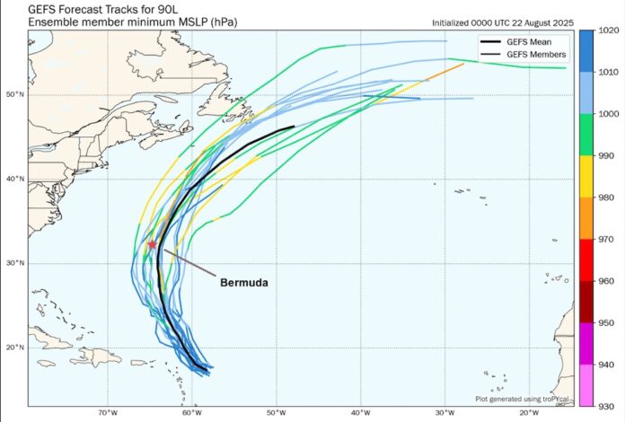
Among several new systems percolating in the Atlantic, the one most likely to develop first is Invest 90L, a disturbance designated by the National Hurricane Center (NHC) on Thursday. As of Friday, 90L was still somewhat disorganized, with only scattered showers and thunderstorms (convection) and some spin evident around an elongated center. 90L was located several hundred miles northeast of the northern Leeward Islands, moving northwest toward the weakness in the steering flow left by Erin.
Ensemble forecast models continue to support development of 90L. The 6Z Friday runs of intensity models from NOAA (HAFS-A, HAFS-B, HMON, and HWRF) all bring 90L to at least tropical storm strength by early next week. In its 8 a.m. EDT Friday Tropical Weather Outlook, NHC gave 90L two-day and seven-day odds of formation of 80% and 90%, respectively. The next name on the Atlantic list is Fernand.
The main area of concern with 90L is Bermuda, as the storm is projected to follow a sharply recurving track toward the northwest and north that could take it near the island on Monday. Wind shear will be light to moderate through Sunday, and 90L will be traversing unusually warm waters with sea surface temperatures of 28 to 29 degrees Celsius (82-84 degrees Fahrenheit). Some of the cooler water upwelled by Erin could affect 90L on Friday and Saturday, although the system is predicted to track far enough east to avoid the main area of upwelling.
99L making its way across the Main Development Region
A slowly developing system designated as Invest 99L on Tuesday continued to move through the Main Development Region of the tropical Atlantic on Friday, midway between Africa and the Lesser Antilles Islands. Invest 99L continued to have a broad, organized circulation on Friday, but satellite scatterometer data could not yet identify a distinct low-level center.
99L had warm sea surface temperatures near 28 degrees Celsius (82°F) to work with, but the main impediment to development was dry air plus moderate wind shear (around 10-20 knots). That shear is predicted to increase on Saturday and then lessen by Sunday into the 10-15 knot range, which may give 99L a better chance of organizing — though dry air will continue to impede development. In its 8 a.m. EDT Thursday Tropical Weather Outlook, NHC gave 99L two-day and seven-day odds of formation of 40% and 50%, respectively.
99L is at a fairly low latitude and is moving generally westward, so residents of the Windward Islands and southern Leeward Islands will want to monitor its progress. The disturbance would most likely reach the islands around Tuesday, but there was little support as of early Friday among ensemble forecast models for significant development.
