
Eastern Nevada hides pockets of life that feel a world apart from neon skylines and interstate rumble. Ranch gates creak in the wind, night skies pulse with stars, and main streets often see more jackrabbits than traffic lights.
These places reward travelers who trade speed for stillness, and they nurture residents who value elbow-room over convenience. Each town on this list has its own quiet rhythm, a few steadfast industries, and a setting that keeps outside bustle at arm’s length.
The following countdown begins with the tiniest communities and works toward the region’s unofficial capital, showing how isolation can take many forms across high desert, alpine meadow, and volcanic canyon. Bring a full tank of gas and an open schedule; our journey starts now.
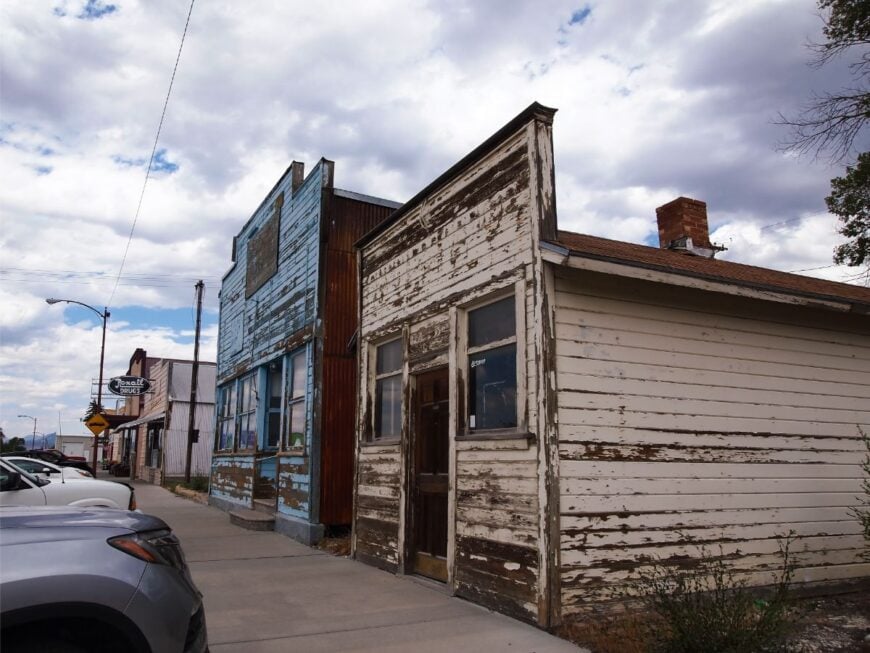
25. Montello – Faded Railroad Outpost on the Salt Flats
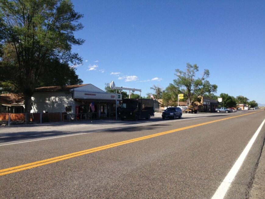
Montello is little more than a scattering of buildings against an ocean of sagebrush, yet its few dozen residents call it home. Once a vital railroad stop for steam engines, the town now feels more like a mirage where time slowed to match the desert wind.
💼🏠 When the CEO of the biggest real estate brokerage on the planet speaks about buying or selling, it’s worth listening. Hear what Robert Refkin has to say.
A single bar and gas pump double as the community hub, where ranch hands, truckers, and curious travelers swap stories. Old brick ruins of hotels and depots whisper of busier days when trains carried ore and cattle across the high desert.
Ranching and occasional railway work provide modest livelihoods, but solitude is the real economy here. Nights bring a silence so deep even coyotes hesitate to break it. It’s the kind of place that reminds you how quiet the world can be.
Where is Montello?
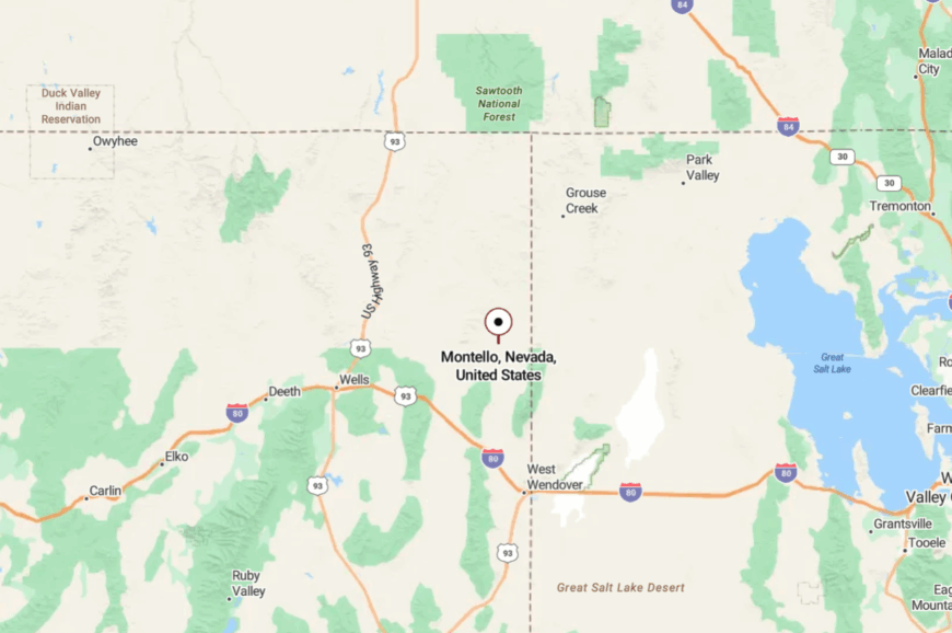
Montello sits in far northeastern Nevada, about 100 miles north of Wells in Elko County. Travelers reach it via U.S. 93 and then a long stretch of Nevada State Route 233, a road that feels endless across sage flats.
The nearest grocery store is nearly an hour away, reinforcing its remoteness. When you arrive, the wide salt flats stretch to the horizon, and the town seems to float on its own island of stillness.
24. Contact – Deserted Mining Crossroads
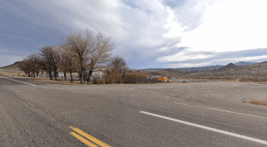
Contact lives half in memory, half in the present. Once a bustling mining camp along the Contact Mine, it now holds only a handful of scattered residents among weathered shacks and leaning storefronts.
The highway bypassed it, leaving a frozen-in-time quality that’s eerie and enchanting. Visitors stop to photograph old stone ruins, wander among sage hills, or fish in nearby Salmon Falls Creek Reservoir. There are no services beyond ranch trucks passing through, no shops to break the silence.
The desert wind threads through boarded windows, carrying echoes of miners long gone. It’s the kind of place that reminds you how quiet the world can be.
Where is Contact?
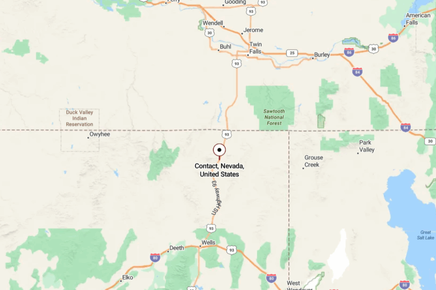
Contact is located in northeastern Elko County, about 25 miles south of the Idaho border. It lies just off U.S. 93, but most travelers cruise past without pausing.
The settlement is reached by a gravel spur, a reminder that the modern road abandoned it decades ago. Arriving feels like stumbling across a forgotten footnote in Nevada’s mining history.
23. Ruby Valley – A Basin of Ranches and Refuge

Ruby Valley stretches wide and green beneath snow-dusted Ruby Mountains, where ranch spreads and marshes share space with sandhill cranes. The valley isn’t a formal town so much as a community of ranch families and wildlife caretakers.
Ruby Lake National Wildlife Refuge is its heart, a wetland oasis where pelicans skim mirrored water and ducks gather by the thousands. Visitors come for birdwatching, fishing, or hunting, but most stay for the stillness that seems to hum in the reeds.
The economy runs on hay, cattle, and a deep respect for water in the desert. With few neighbors in sight, you measure time by the shadows of the peaks. It’s the kind of place that reminds you how quiet the world can be.
Where is Ruby Valley?
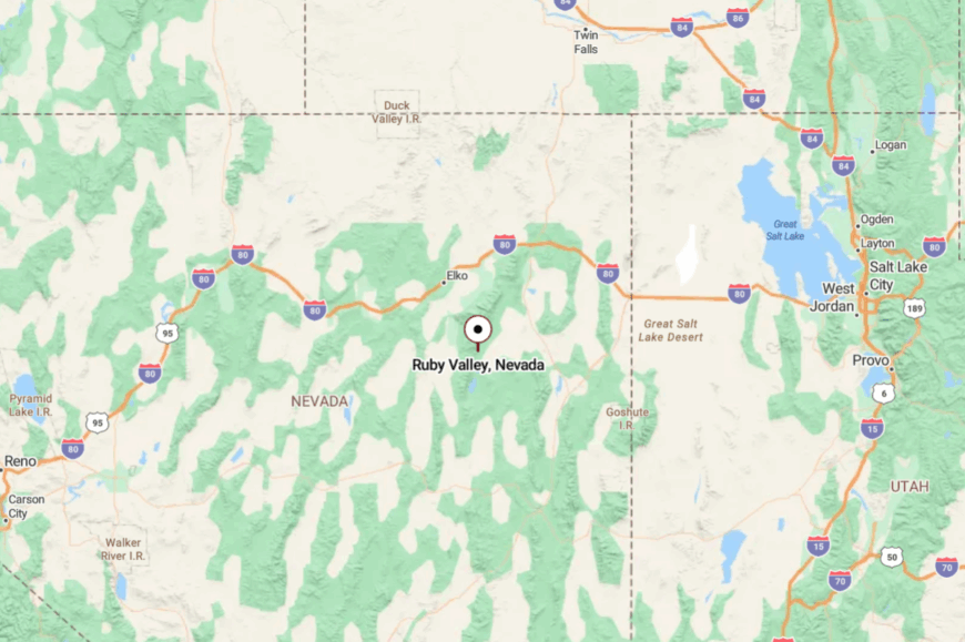
Ruby Valley lies in southeastern Elko County, about 65 miles south of Elko city. Drivers follow NV-229 across the Secret Pass, then descend into the wide basin.
Mountains wall the valley on both sides, giving it a hushed, enclosed feeling. The long approach feels like entering a hidden green world inside the desert.
22. McGill – Smokestacks and Storybook Streets
McGill clings to life in White Pine County, its tidy rows of brick homes built for copper smelter workers a century ago. Though the smelter closed in the 1980s, the community endures with about 1,000 residents who preserve its small-town spirit.
The McGill Drugstore Museum is a local treasure, frozen in 1970s time with jars, prescriptions, and soda fountain counters still intact. Visitors can walk tree-lined streets that feel almost cinematic in their mid-century uniformity.
Many residents commute to Ely, but McGill’s quiet charm belongs to itself. The smokestack ruins watch over the town like a monument to persistence. It’s the kind of place that reminds you how quiet the world can be.
Where is McGill?
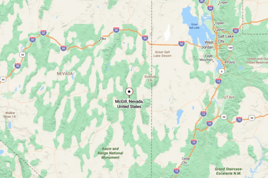
McGill sits ten miles north of Ely in central White Pine County, along U.S. 93. The town was built as a company village for the copper industry, and its grid remains intact.
High desert mountains ring the settlement, buffering it from through traffic. Driving in feels like entering a perfectly preserved chapter of Nevada’s industrial past.
21. Ruth – Copper Shadows Near Ely
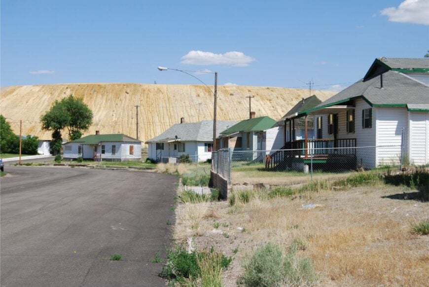
Ruth clings to the side of a giant open-pit mine, its rows of worker houses telling the story of copper’s rise and fall. Once home to thousands, the town now has just a few hundred residents who live beneath the towering tailings of the Robinson Mine.
Walking down its grid streets feels like stepping into a forgotten company town where time stalled but never stopped. A small café and post office serve as gathering places, while old foundations whisper of dance halls and baseball diamonds.
Mining still shapes life here, but the quiet canyon setting gives it a strangely peaceful air. At sunset, the mine walls glow red and the silence returns. It’s the kind of place that reminds you how quiet the world can be.
Where is Ruth?
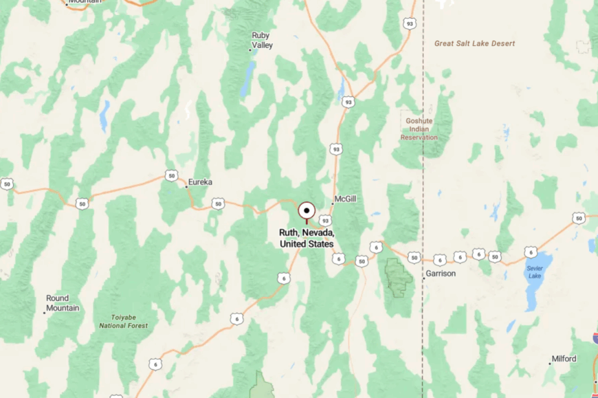
Ruth sits four miles west of Ely in White Pine County, tucked into Robinson Canyon. It’s reached by State Route 50/6, with a short turnoff leading into the grid of homes.
Mountains frame the settlement on all sides, isolating it from the highway’s hum. Arriving feels like entering a pocket carved by both nature and industry.
20. Carlin Canyon – Hidden Bend in the Humboldt
Carlin Canyon feels more like a forgotten refuge than a town, but its cluster of homes and history linger along the Humboldt River. Once a major stagecoach and emigrant trail stop, the canyon was bypassed when Interstate 80 tunneled through nearby cliffs.
Now the old road loops past riverbanks where rafters launch and photographers frame sandstone outcrops. The sense of seclusion lies in being hidden—visible only to those who detour from the highway.
Mining and ranching families still dot the area, living quietly by the water. Echoes of pioneers remain in stone foundations and graffiti carved into the cliffs. It’s the kind of place that reminds you how quiet the world can be.
Where is Carlin Canyon?
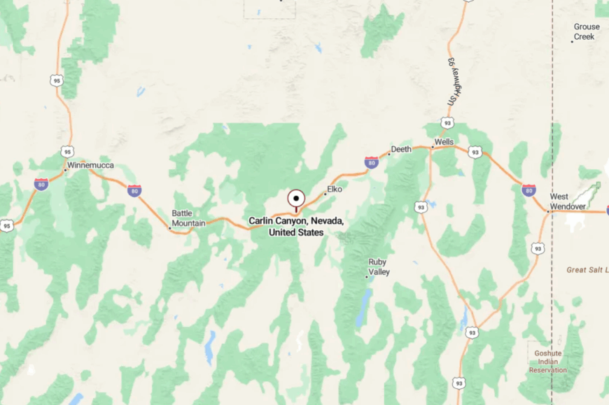
Carlin Canyon is located just east of Carlin in Elko County, along the Humboldt River. Access comes via old U.S. 40, a two-lane road bypassed decades ago.
The canyon walls shelter it from highway roar and city sprawl. The short detour feels like stepping into a hidden chamber carved by time.
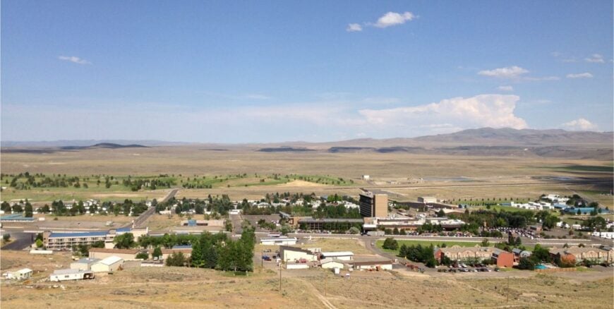
19. Wells – Crossroads at the Foot of the Rubies
Wells has about 1,200 residents, but its quiet streets belie its role as a crossroads. Long-haul truckers refuel here, yet just beyond town lie hot springs, petroglyph sites, and sweeping Ruby Mountain views.
Downtown shows scars from a 2008 earthquake, with a mix of restored and crumbling storefronts adding to its rugged feel. Ranching and service stations keep the economy alive, though adventure seekers stop for ghost towns and hiking trails nearby.
The seclusion comes not from invisibility, but from being overshadowed by the wide land that surrounds it. At sunset, the Rubies glow pink, and the town feels hushed under their shadow. It’s the kind of place that reminds you how quiet the world can be.
Where is Wells?
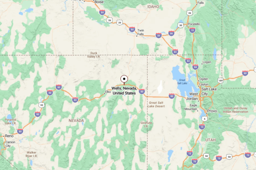
Wells lies in Elko County, at the junction of I-80 and U.S. 93. Though the highways meet here, the town feels detached from their noise, tucked against the base of the Ruby Mountains.
Access is easy, but lingering makes you feel far removed from the pace of travel. The town is close to everything, yet feels like its own pocket of stillness.
18. Caliente – Rail Town in the Canyons
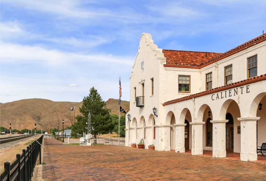
Caliente, with about 1,000 residents, hides in a narrow canyon where cottonwoods line the tracks of the Union Pacific Railroad. Once a bustling division point, its grand 1920s Spanish-style depot still towers over town, now serving as a museum and civic center.
Life here is calm—neighbors gather at the hot springs pool, kids play under the shadow of red cliffs, and mountain bikers set off toward Kershaw-Ryan State Park just minutes away. Small motels, diners, and ranching support the local economy, but the real wealth is its peace.
Surrounded by canyon walls, the town feels insulated from the outside world. As trains rumble through only a few times a day, they sound more like memories than intrusions. It’s the kind of place that reminds you how quiet the world can be.
Where is Caliente?
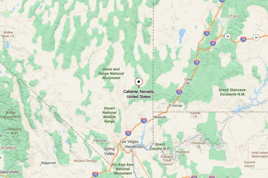
Caliente sits in Lincoln County, 150 miles north of Las Vegas along U.S. 93. The town lies cradled in Meadow Valley Canyon, shielded by red and gray rock walls.
Drivers enter through winding grades that suddenly reveal the green valley floor. The approach feels like discovering a hidden settlement tucked away by the land itself.
17. Jackpot – Neon Oasis on the Border
Jackpot is both lively and lonely, a casino hamlet of about 1,000 souls perched on the Idaho border. Tourists come to gamble, see live shows, and sip cheap cocktails, yet step beyond the casino lights and you find open desert stretching endlessly.
Residents balance service jobs with quiet ranch life in the surrounding hills. Summer brings rodeos and fireworks, while winter often leaves highways empty except for drifting snow. The town thrives on visitors, but its remote location ensures a steady undercurrent of solitude.
Even with neon buzzing, the silence of sagebrush presses close at the edges. It’s the kind of place that reminds you how quiet the world can be.
Where is Jackpot?

Jackpot sits in northern Elko County, directly on U.S. 93 at the Idaho state line. It is 45 miles south of Twin Falls, Idaho, but 200 miles from Nevada’s nearest major city.
Reached by long highway drives through barren desert, it feels isolated despite its gaming halls. Step outside the casino strip, and the wilderness reclaims the night.
16. Mountain City – High Desert Hamlet in the North
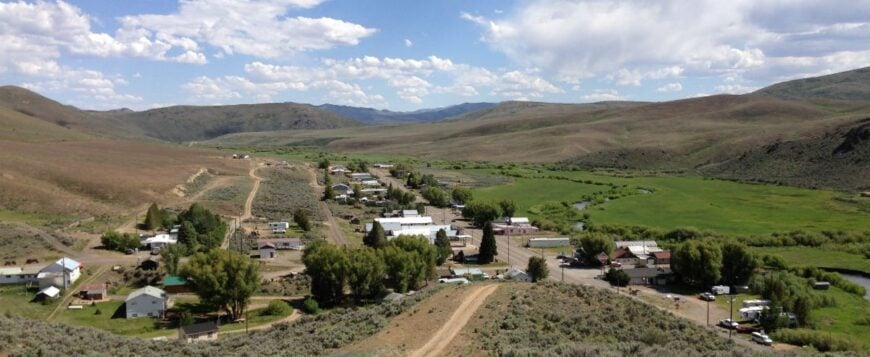
Mountain City is little more than a handful of homes, a post office, and one resilient bar set against rolling sagebrush hills. Once a booming mining town, today only about 50 residents remain, most tied to nearby ranches or outdoor guiding.
Hunters and anglers know it as a gateway to the Owyhee River and the high country around Wildhorse Reservoir, where trout streams and elk herds thrive. Winters are long and snowy, often cutting the town off from easy supply runs, while summers bring vast skies and quiet evenings.
There are no grocery stores or malls here—just solitude, stories, and the sound of wind rushing over the ridges. Its seclusion is its character, a pocket of life holding on in the wide expanse. It’s the kind of place that reminds you how quiet the world can be.
Where is Mountain City?
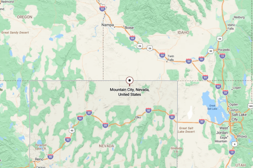
Mountain City sits in far northern Elko County, about 60 miles north of Elko along U.S. 225. The drive passes Wildhorse Reservoir before climbing into open ranch country dotted with junipers.
There are no detours or bypasses; you either come here on purpose or not at all. By the time you arrive, the land’s vast emptiness makes the settlement feel like a secret clinging to the high desert.
15. Spring Creek – Mountainside Retreat by the Rubies
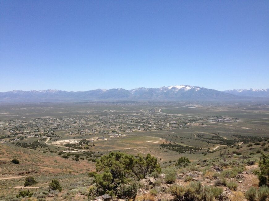
Spring Creek is a sprawling residential community with about 13,000 residents, but its placement beneath the Ruby Mountains makes it feel like a hidden enclave. Built as a planned ranching and retirement development, it stretches across sage hills with views that shift color by the hour.
Residents ride horses along trails, fish at Southfork Reservoir, or take day hikes up Lamoille Canyon just a few miles away. Despite its size, the distance from major interstates and the encircling mountains gives it a sense of seclusion.
Small shops and diners serve locals, but most commutes still run into Elko. The draw here is space, silence, and scenery. It’s the kind of place that reminds you how quiet the world can be.
Where is Spring Creek?
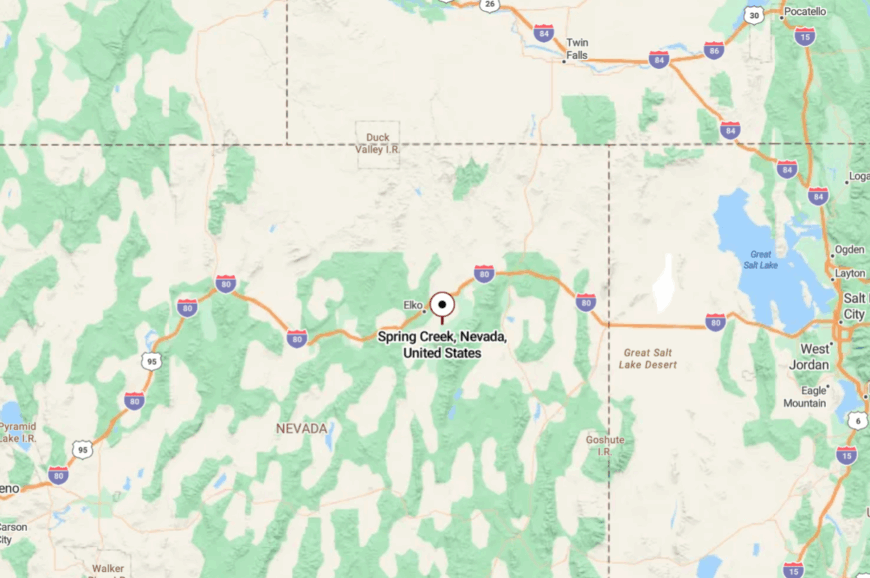
Spring Creek sits 10 miles south of Elko in Elko County, reached by a short drive on State Route 227. Its neighborhoods unfurl across hills and valleys at the base of the Ruby Mountains.
The community is large, yet its mountain backdrop shields it from the rush of nearby highways. Driving in feels like trading noise for open skies.
14. Alamo – Cottonwoods and Desert Springs
Alamo is an oasis town along the Pahranagat Valley, where cottonwoods and ponds break up an otherwise endless desert. With just over 1,000 residents, it’s small but self-sufficient, known for friendly cafés and wide porches.
Birdwatchers flock to the Pahranagat National Wildlife Refuge, where migrating geese and herons gather in marshes. Farmers raise alfalfa in green strips that glow against the tan desert.
Though U.S. 93 passes nearby, the town feels like a bubble of calm far from casino lights or big-box stores. Its quiet nights and still mornings lend it a gentleness rare in Nevada. It’s the kind of place that reminds you how quiet the world can be.
Where is Alamo?

Alamo is located in Lincoln County, 95 miles north of Las Vegas along U.S. 93. The valley’s springs feed marshes that keep it green in the middle of dry country.
The mountains on both sides isolate it from larger towns. Driving in feels like approaching a ribbon of life stretched across desert emptiness.
13. Osceola – Gold Ghost in the Snake Range
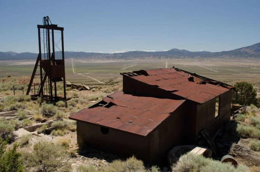
Osceola is a ghost town with only a few modern ranch families nearby, but its history as a rich placer mining camp still echoes. Stone cabins, collapsed sluices, and a cemetery remain for explorers willing to hike in.
Wild horses graze nearby, adding life to the abandoned diggings. Visitors sift tailings for garnets or wander canyons for petroglyphs. Seclusion comes naturally here: no paved road leads in, and the townsite lies far from modern services.
The desert wind whistles through juniper trees, carrying with it whispers of fortune seekers. It’s the kind of place that reminds you how quiet the world can be.
Where is Osceola?
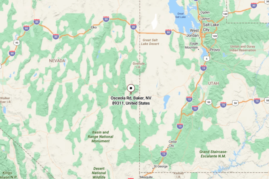
Osceola lies on the western slopes of the Snake Range, about 15 miles west of Baker. It is reached by a rough dirt road branching from U.S. 50.
The mountains shield it from nearby highways, giving it an isolated feel. Once there, the surrounding canyons seem to fold in, hiding you from the world.
12. Baker Ranch – Forgotten Stop in Snake Valley
Baker Ranch is little more than a name on old maps, but a handful of homes and ranches keep it alive along the Nevada-Utah line. Once a stagecoach station, it now feels more like an echo where cottonwoods shade the remnants of corrals.
Ranchers here graze cattle and tend hay fields with water drawn from deep valley wells. Visitors who stumble across it are often birdwatchers chasing hawks and owls that ride the thermals overhead.
There’s no store, no gas, just a scattering of mailboxes at the end of dusty roads. The silence of Snake Valley wraps around everything, giving the place an almost timeless aura. It’s the kind of place that reminds you how quiet the world can be.
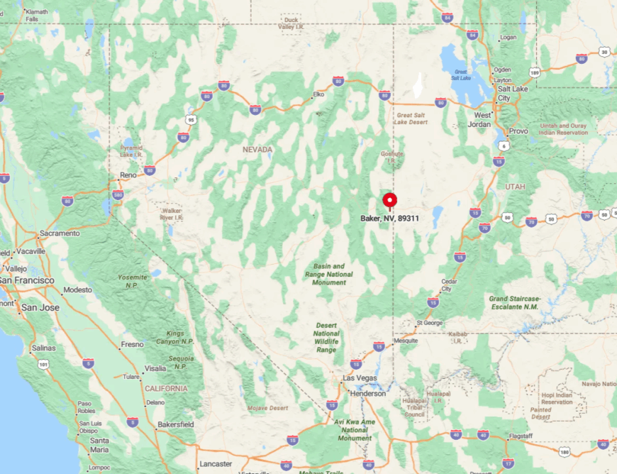
Where is Baker Ranch?

Baker Ranch lies in White Pine County’s Snake Valley, about 15 miles north of Baker along U.S. 6/50. It’s reached by gravel county lanes that branch from the highway toward Utah’s border.
Mountains loom on either side, cutting it off from any larger town. The final stretch feels like rolling into a settlement that exists only if you know where to look.
11. Tuscarora – Artists in a Ghost Camp
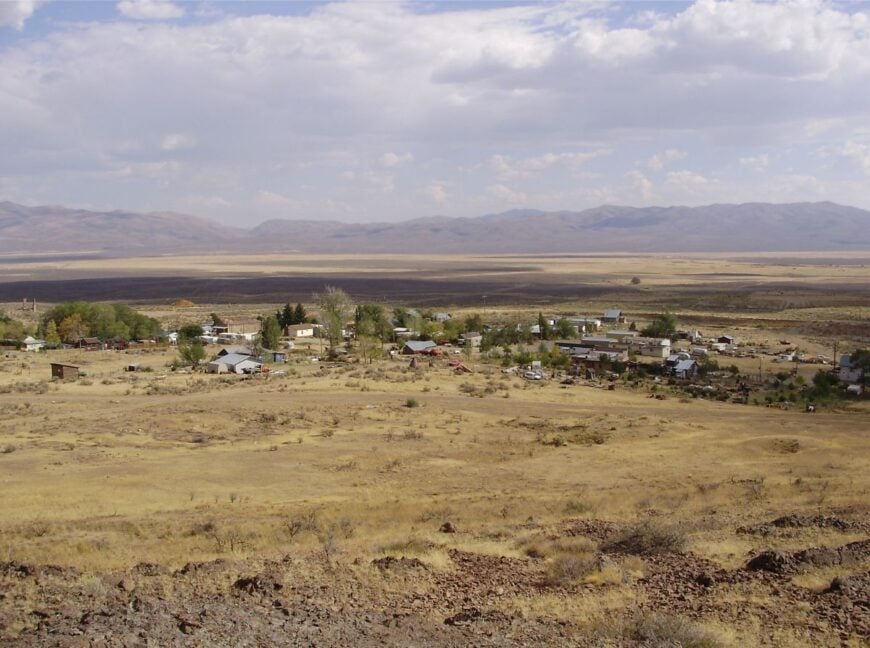
Tuscarora is a nearly empty mining camp reborn as an artist colony, with fewer than 20 full-time residents. Adobe ruins and weathered cabins dot the sage hills, while a pottery school and summer workshops attract creatives seeking solitude.
Visitors can tour historic cemeteries, browse local studios, or hike the Humboldt Range foothills. Ranching and art sales sustain the few who remain. Its isolation is absolute: no gas, no store, only open desert and quiet company.
The vibe blends eerie abandonment with bursts of artistic color. It’s the kind of place that reminds you how quiet the world can be.
Where is Tuscarora?
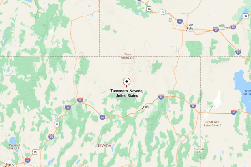
Tuscarora sits in Elko County, about 50 miles north of Elko via a long gravel road. The route winds through sagebrush valleys with no services along the way.
High ridges surround the townsite, cutting it off from easy access. By the time you arrive, the outside world feels like a rumor.
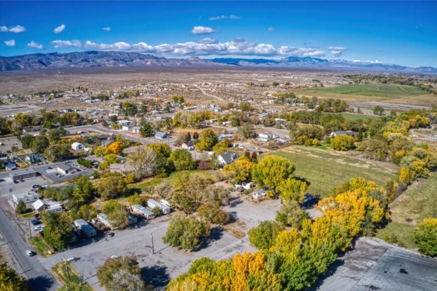
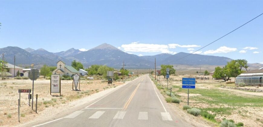
10. Baker – Gateway to Great Basin’s Dark Skies
Baker counts roughly seventy residents tucked against the eastern toe of Nevada’s tallest limestone peak. Visitors spend daylight hours hiking Wheeler Peak’s alpine trails, touring Lehman Caves, or grabbing house-made pastries at the Bristlecone General Store.
Small-scale ranching and seasonal park jobs keep money flowing, while a sprinkling of artists sells star-themed prints to astronomy tourists. The town’s remoteness stems from being four hours from the nearest commercial airport and entirely surrounded by federal land.
Streetlights are deliberately limited, letting the Milky Way sprawl overhead like a private planetarium. Even on summer weekends, silence settles fast once the last visitor drives back toward Highway 50.
Where is Baker?
Baker sits in White Pine County just five miles west of the Utah line along State Route 487. Sagebrush flats and the Snake Range walls cut it off from larger trade corridors, reinforcing a feeling of being on the edge of the map.
Travelers usually reach it by turning south from the “Loneliest Road in America” at the tiny junction of Majors Place. Winter storms can close mountain passes, so locals keep snow tires handy and patience plentiful.
9. Jarbidge – Nevada’s Road-Less Gold Camp
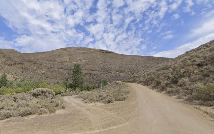
Only about forty hardy people overwinter in Jarbidge, a onetime boomtown hemmed into a steep canyon near the Idaho border. Daytime pursuits include casting for red-band trout in the Jarbidge River, sipping sarsaparilla in The Outdoor Inn’s century-old saloon, or photographing elk that stroll past log cabins.
A bit of small-scale placer mining lingers, but outfitting and summer tourism pay most bills. No paved road reaches the settlement, and the single dirt track often closes under snow from November into June.
Cell service fades thirty miles before the canyon, leaving a rare bubble of total digital quiet. The combination of altitude, narrow walls, and surrounding wilderness keeps Jarbidge feeling like a secret camp from 1910.
Where is Jarbidge?
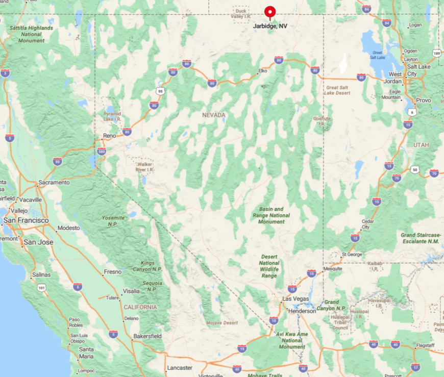
Jarbidge lies in far northern Elko County, 55 rugged miles north of U.S. 93 via graded but rocky county roads. The canyon’s sheer walls block radio signals, and only two small bridges span the river that bisects town.
Summer drivers approach from Elko or from Murphy Hot Springs, Idaho, both routes requiring patience and a spare tire. Winter access is limited to snowmobiles or a long snowshoe haul, which explains why its grocery shelves often feature home-canned peaches instead of fresh produce.
8. Lamoille – Ruby Mountains Meadow Haven
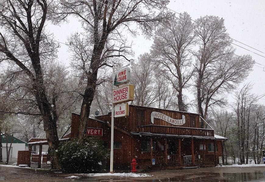
Roughly 130 people call Lamoille home, their houses dotting an emerald meadow beneath 11,000-foot summits. Visitors picnic beside the red-roofed Little Church of the Crossroads, drive the Lamoille Canyon Scenic Byway, and hike to Liberty Lake where mountain goats cling to granite ledges.
Ranching and a handful of guest lodges anchor the local economy, with fall foliage tours providing a short but valuable cash surge. The Ruby Mountains form a horseshoe around the valley, screening it from highway noise and light polluting towns.
After sunset only barn lights flicker, and coyotes provide the evening soundtrack. The sense of a hidden Swiss valley persists even in July when wildflower carpets glow along the creek.
Where is Lamoille?
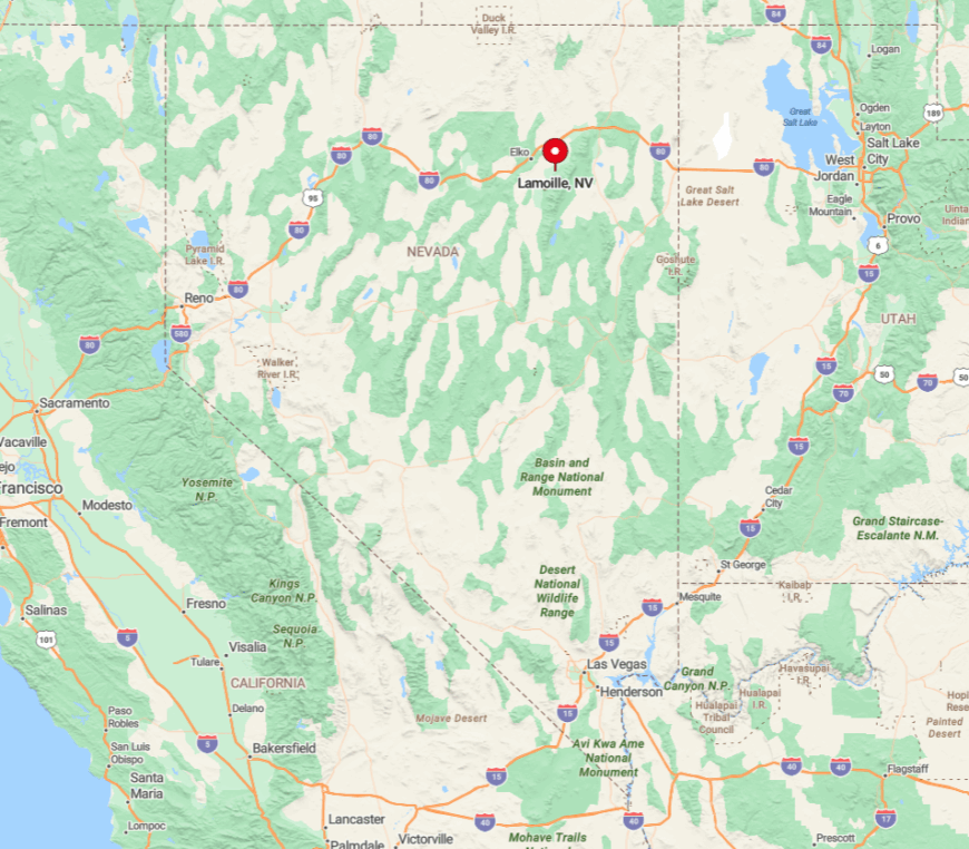
The village sits twenty miles southeast of Elko at the end of State Route 227, a spur that dead-ends deep in the canyon. Because the road stops at forest trailheads instead of continuing onward, few drivers pass through unless they meant to come.
Snow sometimes lingers on the grade until late May, reinforcing the hamlet’s seasonal cocoon. Most supplies arrive in pickup beds from Elko, making the weekly farmers’ market a community event rather than a chore.
7. Duckwater – Oasis on the Big Smoky Desert

About 250 residents, many from the Duckwater Shoshone Tribe, share this green ribbon of springs and cottonwoods in an otherwise arid basin. Activities range from soaking in undeveloped hot pools to watching pronghorn browse near the tribal buffalo pasture or attending the annual spring horse races.
Cattle ranching, hay fields fed by artesian water, and tribal administration form the economic backbone. Isolation is profound: the nearest convenience store sits nearly ninety miles away and mail arrives three times a week by pickup truck.
Dark nights and wide horizons let meteor showers steal the whole sky without contest. Even daytime temperatures feel cooler near the cattail marshes that earned the settlement its evocative name.
Where is Duckwater?

Duckwater hides in Nye County’s Big Smoky Valley, roughly fifty miles west of U.S. 50 via State Route 379. The spur road loses pavement after the first twenty miles, deterring casual detours.
Mountains on both flanks block radio and cell towers, so residents rely on satellite internet for news beyond the valley. Visitors generally top off fuel in Eureka or Ely before venturing into this sage-scented pocket of green.
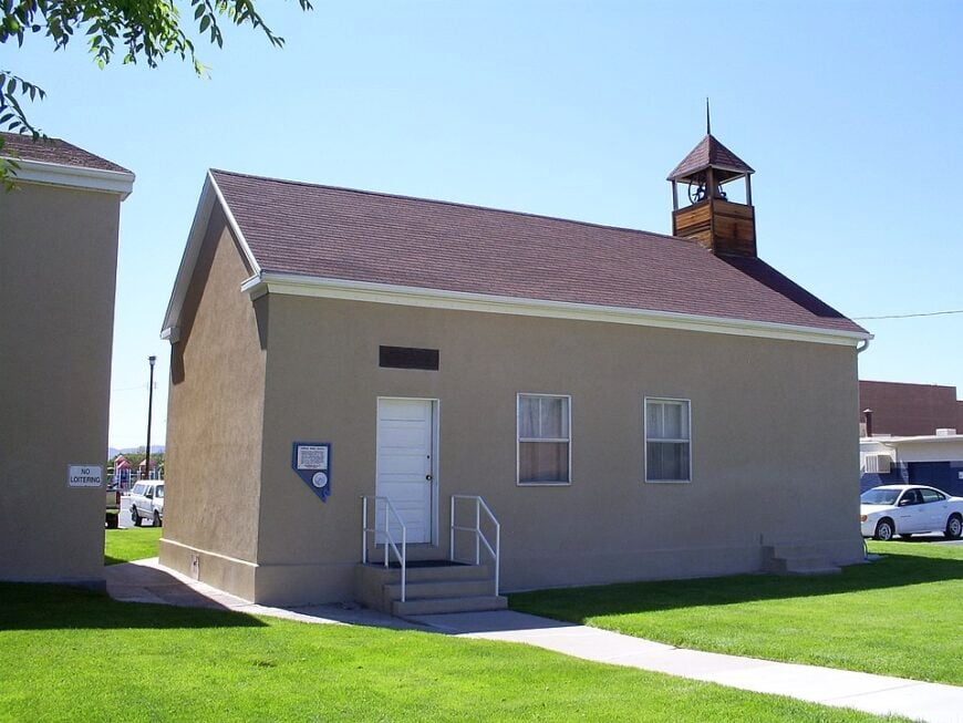
6. Lund – Mormon Pioneer Farm Grids
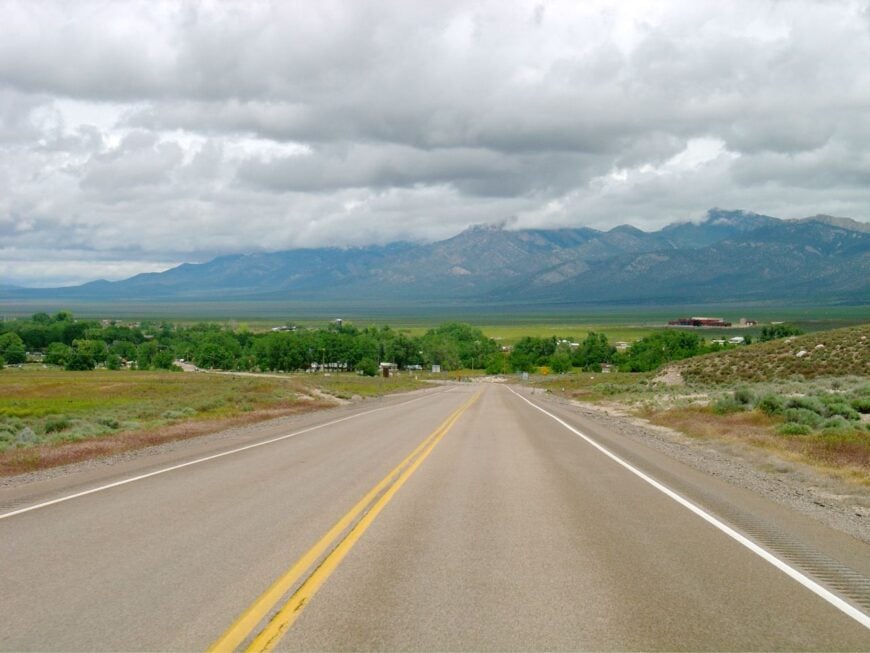
Lund’s population hovers near 300, arranged on tidy one-acre town lots first laid out by Mormon settlers in 1898. Locals cheer high-school rodeo teams, wave at passing cyclists on Highway 318, and spend long summer evenings mending fences or irrigating alfalfa pivots.
Alfalfa and beef cattle dominate the economy, with occasional stints in nearby mining or highway maintenance supplementing household income. Distance keeps things quiet: the closest fast-food chain and hospital are both thirty miles away in Ely.
Even Highway 318 sees more migrating mule deer than semitrucks outside the Silver State Classic Challenge race weekend. Clear air and low humidity make the Milky Way visible by nine o’clock most nights of the year.
Where is Lund?
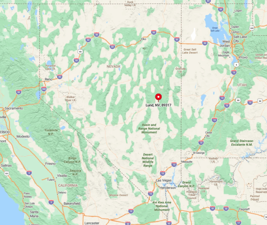
The town rests along State Route 318 in White Pine County, thirty miles south of Ely and thirty-five miles north of Hiko. Mountains bracket both horizons, leaving only ranch tracks leading outward from the paved strip.
Travelers from Las Vegas usually reach Lund after a four-hour drive through almost uninterrupted desert. Fuel pumps close early, so wise visitors plan refills during daylight.
5. Panaca – Red Rock and Quiet Porches
Panaca supports roughly 970 residents who enjoy shady cottonwood lanes and wrap-around porches perfect for stargazing. Daytime draws include exploring Cathedral Gorge’s fluted clay spires, fishing at Panaca Summit Reservoir, and browsing jams at the farmers’ co-op on Main Street.
Farming and positions at neighboring Pioche’s county offices share billing as top employers. The nearest traffic light is over eighty miles away, and freight trains bypass the valley entirely, preserving a slow pace.
Red cliffs encircle the town like a natural amphitheater, softening highway noise into a distant hum. Even July’s Independence Day parade feels intimate enough for participants to greet every spectator by name.
Where is Panaca?

Panaca lies on the eastern flank of Lincoln County, just off U.S. 93 and eight miles from the Utah state line. Cathedral Gorge State Park forms its western border, creating a protected buffer against future sprawl.
Las Vegas sits 170 miles to the southwest, and the stretch between offers only two small gas stations. Most visitors arrive by car, though a seldom-used general aviation strip allows pilots to descend over candy-striped badlands for a memorable landing.
4. Pioche – Clifftop Wild-West Relic
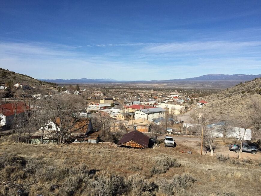
Pioche claims about 700 inhabitants whose hillside homes look out over a wide sweep of sage and juniper. Travelers wander wooden boardwalks, ride the restored incline tramway during Labor Day’s town fair, and swap tall tales at the Thompson’s Opera House that still hosts bluegrass jams.
Government services, heritage tourism, and small-scale gypsum mining sustain the local economy. Perched at 6,060 feet, the settlement escapes summer heat and, more importantly, sits far above any main freight corridor.
At night the clifftop bluffs block light from U.S. 93, letting the town’s few street lamps cast a gentle amber glow. Locals say the ghosts of long-gone gunfighters keep watch from Boot Hill cemetery when the wind gusts through weathered picket fences.
Where is Pioche?
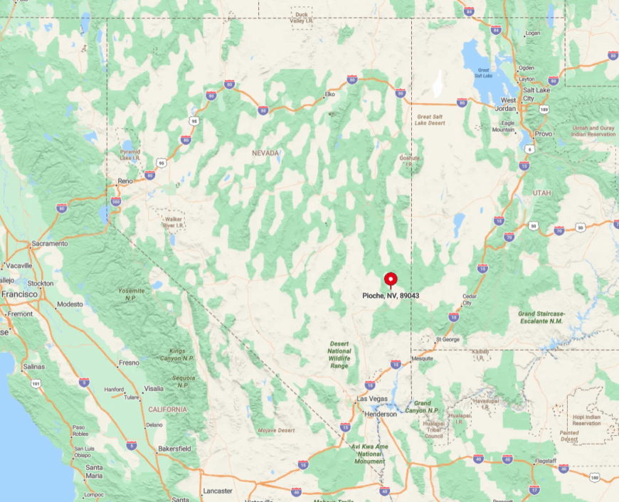
The town hugs a steep escarpment eleven miles north of Panaca, reached by winding State Route 322 that climbs past abandoned mine shafts. Las Vegas traffic thins quickly once drivers pass Crystal Springs, leaving the final ninety miles almost empty.
High altitude and sheer terrain disrupt cell coverage, making Wi-Fi routers on Main Street prized commodities. Visiting pilots sometimes drop into nearby Caselton airstrip, but most arrivals roll in on motorcycles or RVs seeking cooler air.
3. Currie – Ghostly Way-Station on the Ely Line

Cawing ravens outnumber Currie’s roughly twenty permanent residents, whose weather-beaten houses flank a silent rail yard. Photographers stop to frame the cracked depot windows, rusty ore cars, and sage stretching to every horizon.
Cattle ranching provides the only steady paycheck, with hunting guides picking up seasonal work when antelope tags open. The closure of the Nevada Northern Railway line in 1983 froze the town in time and removed its economic lifeline.
No gas station, grocery, or clinic operates within sixty miles, deepening the sense of abandonment. Nightfall covers the empty platforms in a hush broken only by coyotes loping along the tracks.
Where is Currie?
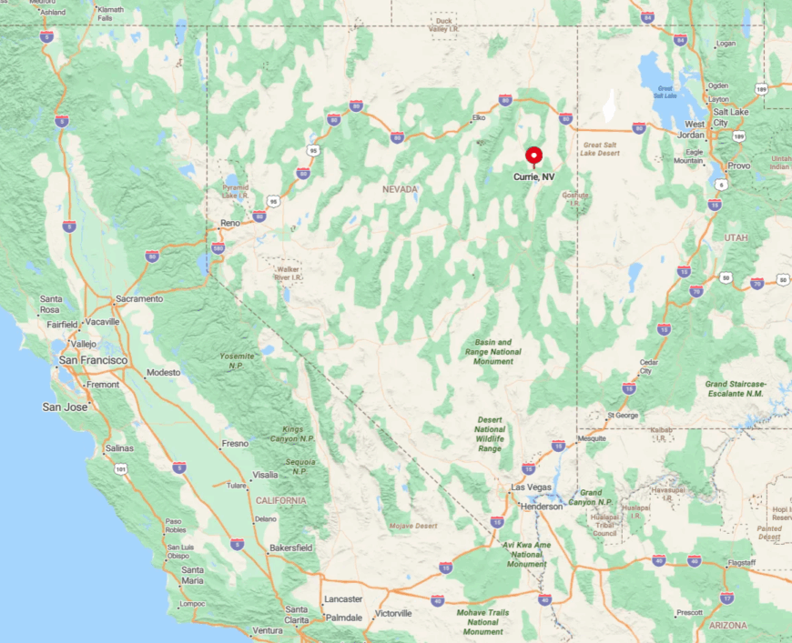
Currie sits in northeastern Nevada’s Goshute Valley beside U.S. 93, sixty-four miles north of Ely and 140 miles south of Wells. Tall peaks on both sides block radio signals, and fiber optic lines have yet to arrive, so satellite dishes sprout beside trailers like futuristic sunflowers.
Drivers find themselves alone for half-hour stretches on the two-lane highway that links the ghost outpost to the outside world. Winter snow regularly drifts across the road, prompting locals to keep coal stoves fueled and a trusty snow shovel by the porch.
2. Cherry Creek – Sagebrush Ghost Town With Residents
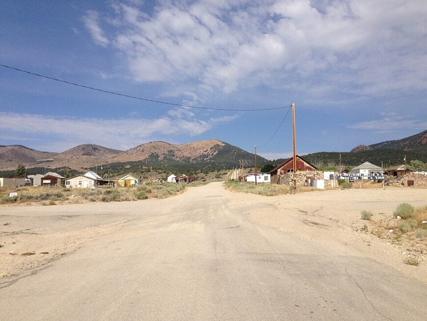
Cherry Creek supports about seventy year-round inhabitants who share space with leaning cabins, collapsed mine headframes, and a scattering of feral burros. Visitors ride ATVs up old prospecting roads, sift through tailing piles for turquoise chips, and swap stories over burgers at the Pine Lodge Bar.
Modern employment comes from ranch work or commuting to Ely’s copper mine, though many residents describe themselves as semi-retired caretakers of history. The settlement sits four miles off the nearest paved road, ensuring dust clouds alert locals to any approach.
Basement speakeasy relics and a one-room jail still stand, giving the area an open-air museum vibe with no admission gate. Coyotes often trot across Main Street at dawn, unfazed by the handful of pickup trucks.
Where is Cherry Creek?
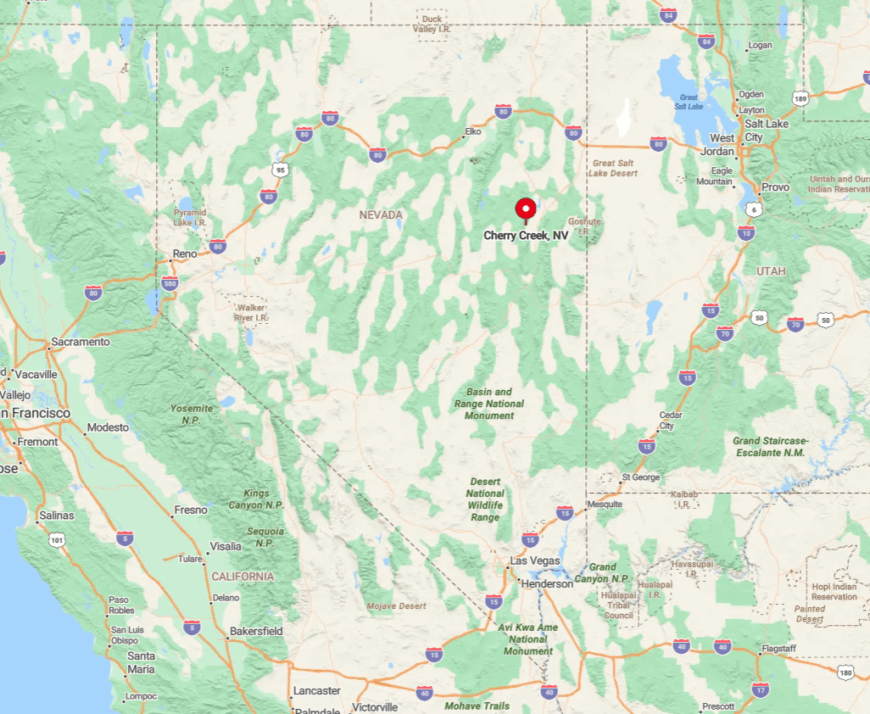
This hamlet nestles against the Steptoe Valley’s western foothills, fifty miles north of Ely via U.S. 93 followed by a graded gravel turnoff. The Schell Creek Range shields it from interstate routes, and heavy snow can make the last four miles a slippery ribbon of mud.
Mail arrives three days a week, and the closest cell tower is so distant that residents joke a pager is still cutting-edge technology here. Anyone arriving after dark should slow for free-roaming burros that treat the county road like their private lounge.
1. Ely – High-Cold Railroad Hub Turned Arts Haven

Ely hosts roughly 4,000 residents across a broad grid of streets surrounded by the Schell Creek and Egan Ranges.
Day visitors climb aboard steam locomotives at the Nevada Northern Railway Museum, photograph downtown murals painted during the annual Ely Renaissance art festival, and cast lines at Cave Lake where ice fishing tournaments liven frigid January mornings.
Copper mining, state government offices, and a growing arts scene keep the local economy diverse enough to weather commodity swings. Yet the town remains remote; it is three hours from any interstate and nearly equidistant from Las Vegas, Salt Lake City, and Twin Falls.
Night skies remain dark because surrounding peaks block urban glow and the nearest big-box store is 120 miles away. That mix of amenities and distance lets Ely feel both self-reliant and surprisingly cultured, an anchor for travelers who still crave frontier breathing room.
Where is Ely?

Ely sits at the crossroads of U.S. 6, 50, and 93 in central White Pine County at 6,437 feet above sea level. The town’s small airport handles only charter flights, so most arrivals cruise in after long desert drives broken by herds of pronghorn and the occasional dust devil.
Mountain walls bracket the city, channeling traffic through just two main canyon passes and insulating it from rapid growth.
Despite being the biggest settlement on this list, Ely’s combination of high elevation, vast surrounding federal land, and long distances to metropolitan neighbors secures its reputation as Eastern Nevada’s most vibrant outpost of seclusion.